
Coconut Island (Queensland) facts for kids
|
Native name:
Poruma
|
|
|---|---|
.png)
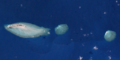
Satellite image of Coconut Island
|
|

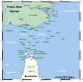
A map of the Torres Strait Islands with the Coconut Island labelled as Poruma
|
|
| Geography | |
| Location | Northern Australia |
| Adjacent bodies of water | Great North East Channel, Torres Strait |
| Administration | |
| State | Queensland |
| Coconut Island / Pormula Island Queensland |
|
|---|---|

Coconut Island / Pormula Island
Location in Queensland
|
|
| Population | 164 (2021 census) |
| Postcode(s) | 4875 |
| LGA(s) | Torres Strait Island Region |
| State electorate(s) | Cook |
| Federal Division(s) | Leichhardt |
Coconut Island, also called Poruma Island or Puruma in the local language, is an island in the Torres Strait, Queensland, Australia. It is one of the many Torres Strait Islands. Coconut Island is about 130 kilometers (80 miles) northeast of Thursday Island. It is both a town and a specific area (locality) within the Shire of Torres.
The people who lived on Coconut Island long ago built their homes from grass, coconut leaves, and wood. This wood often floated down from the jungles of Papua New Guinea via the Fly River.
The islands are home to many interesting things. You can find sea turtle hatcheries, lots of different birds, and huge giant clam areas. There are also giant palm trees, old items from World War II, and very large sand flats.
In 2021, the population of Poruma Island was 164 people.
Island Language and Life
The language spoken on Poruma, or Puruma as it's known locally, is called Kulkalgau Ya. This is a special way of speaking the larger language known as Kalau Lagau Ya.
Poruma, or Coconut Island, is in the middle of the Torres Strait islands. It is a thin coral island, about 1.4 kilometers (0.87 miles) long and 400 meters (1,300 feet) wide. It is surrounded by shallow coral reefs. The Torres Strait Islander people of Poruma are from Melanesia. For thousands of years before Europeans arrived, they lived in villages. They followed old traditions of hunting, fishing, and trading.
The Traditional Owners of Poruma are the Billy and Fauid (Fy-Hood) families.
A Look at History
In the 1860s, boats started coming to the Torres Strait reefs. They were looking for beche-de-mer (sea cucumbers) and pearls. These were valuable items. Some of the first people to collect these around Poruma were an unnamed Frenchman and a man named Colin Thomson.
By the early 1870s, a man called Captain Walton hired people from Poruma. They worked as divers and crew on his boats. An Englishman named George Pearson also ran a pearling station on Poruma in the 1870s. Around 1872, a temporary station for collecting beche-de-mer was set up near the island.
In 1872, the Queensland Government wanted more control over the islands. The British Government then created a new boundary for the colony. This boundary included all islands within 60 nautical miles of Queensland's coast. Later, in 1879, this boundary was made even larger. It reached 96 kilometers (60 miles) and included islands like Boigu, Erub, Mer, and Saibai. This new law helped the Queensland Government manage the pearling and beche-de-mer businesses.
Torres Strait Islanders remember July 1871 as ‘the Coming of the Light.’ This is when missionaries from the London Missionary Society (LMS) arrived. Around 1900, an LMS missionary named Rev. Walker started a business called Papuan Industries Limited (PIL). PIL helped Islander communities buy their own pearl luggers, or ‘company boats.’ These boats were used to collect pearl shells and beche-de-mer. PIL then sold and shared the money from these goods. The people of Poruma bought their first company boats around 1905. These boats gave Islanders income and made them proud. They also made travel and communication between the islands much easier.
In November 1912, the Queensland Government officially set aside 800 acres of land on Poruma as an Aboriginal reserve. Many other Torres Strait Islands became reserves at the same time. A government report from 1912 suggested moving the people of Poruma to Yorke Island. This was so children could go to the new school there. Reports from 1913 show that some families did move, but many chose to stay on Poruma.
By 1918, a Protector of Aboriginals was working on Thursday Island. In the 1920s and 1930s, strict laws were put in place for Torres Strait Islanders. These laws allowed the government to move Islanders to reserves and missions across Queensland. In 1920, a worldwide flu sickness reached the Torres Strait. It caused 96 deaths in the area. The Queensland Government sent food to Coconut, Yorke, and Yam Islands to help them recover. In March 1923, a strong hurricane hit Coconut and Yorke islands. It destroyed local crops and gardens.
In 1936, about 70% of the Torres Strait Islander workers went on strike. This was the first time Torres Strait Islanders had organized a challenge against the government. The strike lasted nine months. It showed how angry Islanders were about the government controlling their lives. They protested against government rules about wages and trade. They also wanted evening curfews lifted and the permit system for inter-island travel removed. They wanted the right to choose their own boat crews.
The strike led to important changes. The unpopular local Protector, J.D McLean, was replaced by Cornelius O’Leary. O’Leary started a system where he regularly talked with elected Islander council members. The new island councils were given some power. They could control local police and courts.
On August 23, 1937, O’Leary held the first meeting of Islander Councillors on Yorke Island. Representatives from 14 Torres Strait communities attended. Mimia and Abiu Fauid represented Poruma at this meeting. After long talks, unpopular rules (like evening curfews) were stopped. A new way for local people to be represented was agreed upon. In 1939, the Queensland Government passed the Torres Strait Islander Act 1939. This law included many ideas from the meeting. A key part of the new law officially recognized Torres Strait Islanders as a separate people from Aboriginal Australians.
During World War II, the Australian Government asked Torres Strait Islander men to join the army. Men from Coconut and other islands formed the Torres Strait Light Infantry Battalion. These soldiers were respected, but they only received one-third of the pay that white Australian soldiers got. On December 31, 1943, members of the Torres Strait Light Infantry went on strike. They demanded equal pay and equal rights. The Australian Government agreed to increase their pay to two-thirds of what white soldiers received. In the 1980s, the Australian Government offered full back pay to these Torres Strait servicemen. After World War II, the pearling industry became less important in the Torres Strait. Islanders were then allowed to work and live on the Australian mainland.
In December 1978, Australia and Papua New Guinea signed a treaty. This treaty set the boundaries between the two countries. It also explained how both countries could use the sea area. The Torres Strait Treaty started in February 1985. It allows people to move freely between the two countries without passports or visas. This free movement is for traditional activities like fishing, trading, and family gatherings. These activities happen in a special Protected Zone and nearby areas.
Coconut Island State School opened on January 29, 1985. On March 23, 2005, its name changed to Poruma State School. On January 1, 2007, the school became part of Tagai State College and was renamed Tagai State College - Poruma Campus.
On March 30, 1985, the Poruma community elected three councillors. They formed an independent Poruma Council under the Community Services (Torres Strait) Act 1984. This law gave Torres Strait Islander councils powers like local governments. The council area, which used to be an Aboriginal reserve, was given to the council on October 21, 1985. On April 24, 2002, the council's name changed to Poruma Island Council. In 2007, a group called the Local Government Reform Commission suggested that the 15 Torres Strait Island councils should be replaced. They wanted one council, the Torres Strait Island Regional Council (TSIRC). In elections on March 15, 2008, people from the 15 communities voted for a local councillor and a mayor. This created a council with 15 councillors and a mayor.
Education
Tagai State College - Poruma Campus is a school for primary students (Early Childhood to Year 6). It is located on Olandi Street (10°03′01″S 143°03′51″E / 10.0503°S 143.0641°E). The main campus of Tagai State College is on Thursday Island.
Amenities
The Torres Strait Island Regional Council runs the Poruma (Ngalpun Ngulaygaw Lag) Library. You can find it on Main Street.
Images for kids
-
Satellite image of Coconut Island
-
A map of the Torres Strait Islands with Coconut Island labelled as Poruma
