
Darnley Island (Queensland) facts for kids
|
Native name:
Erub
|
|
|---|---|
.png)
A satellite image of Darnley Island
|
|

A map of the Torres Strait Islands showing Erub in the north-eastern waters of Torres Strait
|
|
| Geography | |
| Location | Torres Strait |
| Coordinates | 9°35′13″S 143°46′16″E / 9.587°S 143.771°E |
| Archipelago | Torres Strait Islands |
| Total islands | 1 |
| Administration | |
|
Australia
|
|
| State | Queensland |
| Demographics | |
| Population | 400 |
| Darnley Island / Erub Island Queensland |
|
|---|---|

Darnley Island / Erub Island
Location in Queensland
|
|
| Population | 326 (2021 census) |
| • Density | 57.2/km2 (148/sq mi) |
| Postcode(s) | 4875 |
| Area | 5.7 km2 (2.2 sq mi) |
| Time zone | AEST (UTC+10:00) |
| Location |
|
| LGA(s) | Torres Strait Island Region |
| State electorate(s) | Cook |
| Federal Division(s) | Leichhardt |

Darnley Island, also known as Erub in the traditional Meriam Mir language, is a volcanic island in the eastern Torres Strait, Queensland, Australia. It is part of the Torres Strait Islands and is close to the Great Barrier Reef.
The main town on the island is also called Darnley. The wider area is known as Erub Island. Both are part of the Torres Strait Island Region local government area. In 2021, Erub Island had 326 people living there. Most of them (89.6%) were Indigenous Australians.
The main language spoken by the community is Brokan, which is also called Torres Strait Creole. Many people also still speak Meriam Mir, the traditional language of the island.
Contents
Island History
The island was named by Captain William Bligh in 1792. He named it after a distant relative, the Earl of Darnley. This happened during Bligh's second trip to the Pacific to collect breadfruit.
The Coming of the Light

In 1871, missionaries from the London Missionary Society (LMS) arrived in the Torres Strait. They came on a ship called Surprise. They had been asked to leave other islands and decided to come to the Torres Strait and New Guinea.
On 1 July 1871, the missionaries reached Erub. This day is now known as the "Coming of the Light". An elder from the island, Dabad, met them at Kemus Beach. He then introduced them to Amani, another elder, and the rest of the Erub Islanders.
Dabad's role in bringing Christianity to the Torres Strait is remembered at Dabad's Monument. The monument says he "denied his tribal laws and accepted the good news of salvation." All Torres Strait Island communities celebrate the Coming of the Light every year on July 1st.
Early Industries and Changes
For many years, people came to Darnley Island for pearling and to gather beche-de-mer (sea cucumbers). These industries brought sailors from the Pacific Islands, the Philippines, and Malaya. Many of these sailors married local women and made the island their home.
In the early 1900s, the Queensland Government began to set up services on the island. These included a school, a health center, a post office, and a store.
All Saints Church
In 1919, the All Saints Church was built. It stands where the first London Missionary Society mission house and school used to be. The church was built using local materials like lime from burnt coral and basalt. It was built under the guidance of Manai, an Erub Islander, and Ware, a South Sea Islander. It was first known as the Ziona church.
Education on the Island
Darnley Island State School opened on 29 January 1985. It took the place of the older mission school. In 2007, it became the Darnley Island Campus of the Tagai State College. The main campus of Tagai State College is on Thursday Island.
Protecting Land Rights
Darnley people have played a big part in the fight for Torres Strait Islanders' rights. From the 1960s to the 1990s, George Mye was an important elder and a strong supporter of Islander interests.
Carlemo Wacando was one of the first to challenge the idea of terra nullius. This idea meant that Australia claimed the land was empty before Europeans arrived. The High Court of Australia decided in the Mabo v Queensland (No 2) case (1992) that Torres Strait Islanders had traditional land ownership. This ruling also helped Aboriginal claims to their lands. The Native Title Act of 1993 was then passed to manage these changes.
In 2015, Pau Enterprises Indigenous Corporation was created. Its job is to manage the Pau family's native title lands and interests on Darnley Island. It also works to create businesses on Darnley Island and in places like Cairns where community members have moved.
Darnley Island became more widely known in Australia in 2015. The acting school principal asked for book donations for the primary school children. Her request was shared over 18,000 times on Facebook. Hundreds of books were then sent to the island.
Island Population
In 2016, Erub Island had a population of 328 people. By 2021, the population was 326 people. Of these, 292 (89.6%) identified as Indigenous Australians.
Nature and Wildlife
The Kinabalu giant earthworm, Pheretima darnleiensis, is named after Darnley Island. However, it is likely that this type of earthworm was brought to the island by people.
Important Places

Darnley Island has one site listed as a heritage-listed place: the All Saints Anglican Church.
Island Facilities
The Torres Strait Island Regional Council runs an Indigenous Knowledge Centre in Madige Village on Erub. This center helps share local knowledge and culture.
The island also has two stores, a school, and a health center. Visitors can find accommodation at Norah's Guest House. The council also provides 'five star' dongas (simple cabins) for lodging.
Learning on Darnley Island
Darnley Island Campus is a primary school for children from Early Childhood to Year 6. It is part of Tagai State College. There is no secondary school on the island.
The secondary campus of Tagai State College is on Thursday Island, which is over 200 kilometers away. Some boarding facilities are available there. However, many children are also sent to high schools on the mainland of Australia.
Images for kids
-

Joe Rotumah's house on Darnley Island with India rubber planted in 1890-1898
-
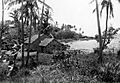
Houses on the beach, 1949
-
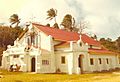
All Saints Anglican Church, 1971
