
Seisia, Queensland facts for kids
Quick facts for kids SeisiaQueensland |
|||||||||||||||
|---|---|---|---|---|---|---|---|---|---|---|---|---|---|---|---|

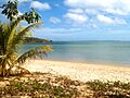
Beach at Seisia, 2011
|
|||||||||||||||

Seisia
Location in Queensland
|
|||||||||||||||
| Population | 293 (2021 census) | ||||||||||||||
| • Density | 127.4/km2 (330/sq mi) | ||||||||||||||
| Postcode(s) | 4876 | ||||||||||||||
| Area | 2.3 km2 (0.9 sq mi) | ||||||||||||||
| Time zone | AEST (UTC+10:00) | ||||||||||||||
| Location | |||||||||||||||
| LGA(s) | Northern Peninsula Area Region | ||||||||||||||
| State electorate(s) | Cook | ||||||||||||||
| Federal Division(s) | Leichhardt | ||||||||||||||
|
|||||||||||||||
Seisia is a coastal town in the Northern Peninsula Area Region of Queensland, Australia. In 2021, Seisia had a population of 293 people. It is known for its beautiful beaches and as a gateway to the Torres Strait Islands.
Contents
Exploring Seisia's Location

Seisia is located on the northern part of Cape York Peninsula. It sits north of New Mapoon and west of Bamaga.
The community of Seisia is on a special area of land called a Deed of Grant in Trust (DOGIT). This land was given by the Queensland Government in 1986. Seisia is the most northern town on the Australian mainland. It has a busy harbour where supply ships and ferries dock.
Even though Seisia is far from big cities, it is well connected. Regular ferry services link Seisia to Thursday Island. Thursday Island is the largest town in the Torres Strait. The ferry trip takes about 90 minutes.
Seisia's Past: A Journey Through Time
Early Days and European Arrival
Seisia was once called Red Island Point. In the local Aboriginal language, its name is Ithangee. This area was a traditional camping spot for the Oiyamkwi clan of the Ankamuti people. They lived here long before Europeans arrived.
In 1864, a government settlement was set up at Somerset. This was at the very tip of Cape York. Sadly, new diseases and changes to their hunting grounds affected the local Aboriginal people. By 1915, many survivors gathered at Red Island Point and Cowal Creek. Different Aboriginal groups, like the Yadhaigana, Wuthathi, and Gudang people, came together at Red Island Point.
These communities asked the government for land to grow food. This led to the creation of an Aboriginal reserve at Cowal Creek in 1915. An Anglican mission and school began to manage this reserve in 1923.
Seisia During World War II
.jpg)
During World War II in 1942, the US Army built a military airstrip near Red Island Point. This airstrip was called Jacky Jacky or Higgins. The RAAF used it for bombers, fighters, and transport planes. Today, it is still the airport for the Northern Peninsula Area.
A radar station was also built at Muttee Heads in 1943. Local Aboriginal people helped build and operate it. New jetties and wharves were constructed by Army engineers at Muttee Heads and Red Island Point.
A New Home for Torres Strait Islanders
After World War II, the Queensland Government wanted to thank Torres Strait Islanders for their help in the war. They also wanted more people to live in the north for defence. Around 1945, government officials looked for new settlement spots.
Torres Strait Islander men from Saibai, Dauan, and Boigu talked about moving to the Australian mainland. They continued these talks after the war. An elder from Saibai, Bamaga Ginau, supported the idea. He was worried about the lack of fresh water and firewood on Saibai. He also worried about poor drainage and damaging king tides.
In 1947, very high king tides caused a lot of damage on Saibai. Bamaga Ginau called a meeting about the future of Saibai. Many families decided to leave the island and move to the mainland.
The first families from Saibai left in May 1947. They arrived at Muttee Heads on June 1, 1947. Another group, including Bamaga Ginau, arrived on July 1, 1947. They chose Muttee Heads as a temporary home.
In 1948, the Queensland Government set aside a large area of land for Torres Strait Islanders. This land stretched from Red Island Point to Kennedy Inlet. More families from Saibai settled at Red Island Point in 1950 and 1951. They lived in old army huts. In 1955, they asked for new houses to be built.

On October 14, 1972, the Anglican Church of St. Francis of Assisi was opened at Red Island Point. Five years later, the community officially adopted the name Seisia. The name Seisia comes from the first letters of the names of Mugai Elu's fathers and brothers: Sunai, Elu, Ibuai, Sagaukaz, Isua, and Aken.
Seisia Today: Local Government
In 2007, a special group suggested changes to local government. They recommended combining several councils into one. This led to the creation of the Northern Peninsula Area Regional Council (NPARC). The first NPARC was elected in 2008. This council helps manage the region, including Seisia.
Seisia's Population
The number of people living in Seisia has grown over the years:
- In 2006, Seisia had 165 people.
- In 2016, the population grew to 260 people.
- By 2021, Seisia was home to 293 people.
Learning in Seisia
There are no schools directly in Seisia. However, students can attend the Northern Peninsula Area State College in nearby Bamaga. This college has a junior campus for younger students (kindergarten to Year 6). It also has a senior campus for older students (Years 7 to 12).
Community Services and Facilities
- The Seisia Primary Health Care Centre helps people stay healthy. It is managed by Indigenous health workers and has visiting specialists. You can find it on Mugai Street.
- The Seisia Community Hall is a place for community events and gatherings. It is located on Tumema Street.
Things to Do and See in Seisia

Seisia is a popular spot for fishing. Many fishing tour operators use Seisia as their base. There is also a campground that attracts many travelers visiting the Northern Cape York Peninsula.
Seisia is becoming known as the "Gateway to the Torres Strait." It is a great place to learn about Torres Strait Islander culture. You can take tours from Seisia to several Torres Strait islands. These tours often include market days on Saibai. They help visitors understand the history between Seisia and the Torres Strait. If you love fishing, you can find many recreational fishing guides through the Seisia Village campground.
Images for kids
-
Beach at Seisia, 2011
