Umagico, Queensland facts for kids
Quick facts for kids UmagicoQueensland |
|||||||||||||||
|---|---|---|---|---|---|---|---|---|---|---|---|---|---|---|---|

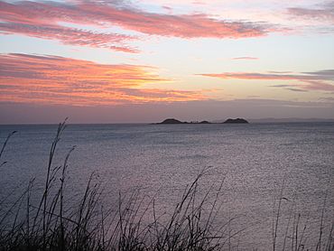
View across the sea at Umagico, 2007
|
|||||||||||||||
| Population | 394 (2021 census) | ||||||||||||||
| • Density | 7.680/km2 (19.89/sq mi) | ||||||||||||||
| Postcode(s) | 4876 | ||||||||||||||
| Area | 51.3 km2 (19.8 sq mi) | ||||||||||||||
| Time zone | AEST (UTC+10:00) | ||||||||||||||
| Location | |||||||||||||||
| LGA(s) | Northern Peninsula Area Region | ||||||||||||||
| State electorate(s) | Cook | ||||||||||||||
| Federal Division(s) | Leichhardt | ||||||||||||||
|
|||||||||||||||
Umagico is a town and coastal area in the Northern Peninsula Area Region, Queensland, Australia. In 2021, Umagico had a population of 394 people.
Umagico is one of five communities that make up the Northern Peninsula Area (NPA). This area covers about 1,030 square kilometers at the very top of Cape York Peninsula. The other communities in the NPA are Injinoo, New Mapoon, Seisia, and Bamaga. There is also an undeveloped town called Aloa (10°53′05″S 142°21′04″E / 10.8848°S 142.3511°E) nearby on the coast.
Contents
Umagico's Past
Umagico was originally known as Alau by local people. It was one of many traditional camping spots for Aboriginal people along the western beaches of Northern Cape York Peninsula. The Gumakudin people are believed to have lived in Alau before the British arrived.
Early Challenges
In 1897, a report by Archibald Meston said that the Aboriginal population between Newcastle Bay and Cape York had dropped a lot. It went from 3,000 people to fewer than 300. By 1900, many Aboriginal people in the Cape York Peninsula area had died. This was due to new diseases, being kept away from their traditional hunting grounds, and harsh treatment from the Native Police.
Community Regroups
By 1915, the remaining Aboriginal people had gathered at Red Island Point (now Seisia) and Cowal Creek (now Injinoo). Both groups asked the Queensland Government for land to grow food. This led to the creation of an Aboriginal reserve at Cowal Creek in 1915.
By 1918, the Cowal Creek community was managing itself with a council they had chosen. The community grew in the 1920s and 1930s as more Aboriginal groups joined them. These groups came from places like the McDonnell Ranges, Red Island Point, and Seven Rivers. In 1923, Anglican missionaries and teachers arrived at Cowal Creek. They started to help with the community's management.
New Settlements
After World War II, more people came to Northern Cape York Peninsula. Torres Strait Islanders began to settle in the area. The government started to develop the region to help these new settlers. Many Islanders from Saibai Island moved to Red Island Point and Muttee Heads in 1948 after a big storm flooded their island. The government created a reserve at Red Island Point in 1948, which was then combined with the Cowal Creek Reserve. This larger reserve covered about 97,620 acres and had around 350 people.
During the 1950s, many Saibai Islanders moved to Bamaga. The government was developing Bamaga, building homes, and creating farming and timber industries. Bamaga became the main administrative center for the Northern Peninsula Area.
Umagico's Founding
Umagico was officially started in 1963. The government moved 64 Aboriginal people from Lockhart River Mission to this area. The Anglican Church had stopped managing the Lockhart River Mission in 1960. The government wanted to close the mission and move everyone to Bamaga. However, most people chose to stay at the old mission site. Those who moved to Umagico accepted it as a new home.
Later, after the Lockhart River community was rebuilt in a new location in 1970, some people who had moved to Umagico returned to Lockhart. Around the same time, people from Moa Island in the western Torres Strait also moved to Umagico.
The Umagico Indigenous Knowledge Centre was opened in 2012.
Population Details
In 2016, Umagico had 427 people. About 94.1% of them identified as Aboriginal or Torres Strait Islander. This is much higher than the average for Queensland (4.0%) and Australia (2.7%).
In 2021, the population of Umagico was 394 people. About 89.8% of the people identified as Aboriginal or Torres Strait Islander. This is still higher than the Queensland average (4.8%) and the Australian average (3.2%).
Schools and Learning
There are no schools directly in Umagico. The closest primary schools are part of the Northern Peninsula Area College. Their junior campus is in nearby Injinoo (to the south-west) and another junior campus is in Bamaga (to the east). The closest high school, the senior campus of the Northern Peninsula Area College, is also in Bamaga.
Local Places
The Northern Peninsula Area Regional Council runs the Umagico Indigenous Knowledge Centre. You can find it at 8 Charlie Street (10°53′33″S 142°21′05″E / 10.89238°S 142.35140°E).
The Umagico Community Hall is located at the corner of Peter Street and Wassey Street (10°53′31″S 142°21′12″E / 10.8920°S 142.3533°E).
Important Services
The Umagico Primary Health Care Centre is on the corner of Charlie Street and Woosup Street (10°53′33″S 142°21′02″E / 10.8925°S 142.3505°E).
The Umagico cemetery is located in Pascoe Street (10°53′27″S 142°20′51″E / 10.8908°S 142.3474°E).
 | Selma Burke |
 | Pauline Powell Burns |
 | Frederick J. Brown |
 | Robert Blackburn |


