
Lockhart River, Queensland facts for kids
Quick facts for kids Lockhart RiverQueensland |
|||||||||||||||
|---|---|---|---|---|---|---|---|---|---|---|---|---|---|---|---|

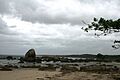
Quintell Beach in Lockhart River
|
|||||||||||||||

Lockhart River
Location in Queensland
|
|||||||||||||||
| Population | 640 (2021 census) | ||||||||||||||
| • Density | 0.1089/km2 (0.282/sq mi) | ||||||||||||||
| Postcode(s) | 4892 | ||||||||||||||
| Elevation | 17 m (56 ft) | ||||||||||||||
| Area | 5,877.0 km2 (2,269.1 sq mi) | ||||||||||||||
| Location | |||||||||||||||
| LGA(s) |
|
||||||||||||||
| State electorate(s) | Cook | ||||||||||||||
| Federal Division(s) | Leichhardt | ||||||||||||||
|
|||||||||||||||
|
|||||||||||||||
Lockhart River is a town and coastal area in Queensland, Australia. It's located on the eastern side of the Cape York Peninsula. This town is home to an Aboriginal community. From 1924 to 1967, a special mission was run here by the Anglican Church. In 2021, about 640 people lived in the Lockhart River area.
Contents
Exploring Lockhart River's Location
Lockhart River is an Aboriginal community right on the coast. It's on the eastern side of the Cape York Peninsula in Queensland, Australia. Most of the people living here are Aboriginal and Torres Strait Islanders. Their ancestors were moved to this area starting in 1924.
The area also includes several islands just off the east coast. These are Chapman Island, Lloyd Island, Rocky Island, Sherrard Island, and Sunter Island. All these islands are part of the Aboriginal Shire of Lockhart River.
The town is about 800 kilometers (497 miles) north of Cairns by road. It's also around 2,550 kilometers (1,584 miles) north of Brisbane by road. Lockhart River is the most northern town on Australia's east coast. The community itself is about 2 kilometers (1.2 miles) inland from Quintell Beach. It's also located inside the Kutini-Payamu National Park.
A Look at Lockhart River's Past
Lockhart River gets its name from a river about 14 kilometers (8.7 miles) south of the community. An explorer named Robert Logan Jack named the river in January 1880. He named it after his good friend, Hugh Lockhart.
Early European Arrivals
The first non-Indigenous people arrived in 1848. Explorer Edmund Kennedy set up a base camp near the mouth of the Pascoe River. He left eight men at the camp. When a supply ship finally found them, only two men were still alive. The others had died from sickness and not enough food.
By the 1870s, fishermen came to the coastal areas. They were looking for sea cucumbers (trepang), pearl shells, and trochus shells. Miners also came to the hills around Gordon Creek. They were searching for tin and gold. Timber cutters were also active in the inland areas near the Wenlock River.
The Lockhart River Mission (1924–1967)
The Anglican Church started a mission at Orchid Point in 1924. This spot had been a place where sandalwood was traded. Aboriginal people from different parts of the Cape York Peninsula were brought to this mission. It was known as the Lockhart River Mission.
Six months later, the mission moved to Bare Hill, south of Cape Direction. In the 1930s, Lamalama people were forced to move to the mission. They came from the Port Stewart area. However, they later returned to their home. In 1939, many people who had been moved from Coen also went back to the Coen area.
When Second World War started in 1942, the European leader of the mission left. The Aboriginal people were told to go to bush camps and find food for themselves. After six months, in July 1942, the mission reopened. But it had very few supplies and not much money. Things got better in the 1950s under a new leader, John Warby. A group was formed in 1954 to manage the trochus shell industry. This helped until the market for shells failed. New houses were built, and a village was created near the ocean.
In 1967, the church gave the mission to the Queensland government. The government tried to move the people to Bamaga. But most people did not want to go. In 1968–1969, the people were moved from their traditional land. This land belonged to the Uutaalnganu people on the coast. They were moved to a new place in Kuuku Ya'u country, further north and inland. This move caused a lot of unhappiness and problems.
The Lockhart River Community gained special land rights in 1987. This means local elected leaders now manage the land for the community.
World War II and Other Events
Lockhart State School first opened its doors on January 1, 1924.
During World War II, Lockhart River Airport was built. It became a large American bomber base with three airstrips. US bombers flew from here to Papua New Guinea. Fighter planes from Bamaga and Horn Island would meet them. Thousands of US and Australian troops passed through this area. They trained for jungle warfare before going to southeast Asia. Many flights from the base helped fight Japanese forces during the important Battle of the Coral Sea in May 1942.
The community of Portland Roads, 40 kilometers (25 miles) north of Lockhart River, was a supply port for the war. It had a large pier, which has since been removed. You can still find old bunkers and rusty oil drums in the bush areas.
The Iron Range Post Office opened on November 5, 1936. It closed in 1942, reopened in 1950, and was renamed Lockhart River in 1978.
On May 7, 2005, a plane crashed in the Kutini-Payamu (Iron Range) National Park. The plane was flying from Bamaga to Cairns, with a stop in Lockhart River. All 15 people on board died in the crash.
On April 11, 2014, the area known as Lockhart was divided. It became two new areas: Iron Range and Lockhart River.
How Lockhart River is Governed
Lockhart River is both a town and a coastal area. The town is located within the Aboriginal Shire of Lockhart River. The coastal area is split between the Aboriginal Shire of Lockhart River and the Shire of Cook.
Lockhart River's Climate
Lockhart River has a tropical savannah climate. This means it has a very wet season from November to May. The dry season is from June to October. During the dry season, temperatures are a bit cooler and there is less humidity. Temperatures stay warm to hot all year. The highest average temperatures are in December (around 32.3°C or 90.1°F). The lowest average temperatures are in July (around 27.2°C or 81.0°F).
Lockhart River gets a lot of rain each year, about 2,074.9 millimeters (81.7 inches). Because of all the rain, there are only about 36 clear days each year. The hottest temperature ever recorded was 40.2°C (104.4°F) in November 1990. The coldest was 3.3°C (37.9°F) in July 1965.
| Climate data for Lockhart River (12º47'24"S, 143º18'00"E, 19 m AMSL) (1965-2024 normals and extremes, rainfall to 1956) | |||||||||||||
|---|---|---|---|---|---|---|---|---|---|---|---|---|---|
| Month | Jan | Feb | Mar | Apr | May | Jun | Jul | Aug | Sep | Oct | Nov | Dec | Year |
| Record high °C (°F) | 38.0 (100.4) |
37.0 (98.6) |
36.0 (96.8) |
34.3 (93.7) |
33.6 (92.5) |
31.6 (88.9) |
31.9 (89.4) |
32.0 (89.6) |
35.2 (95.4) |
37.7 (99.9) |
40.2 (104.4) |
39.8 (103.6) |
40.2 (104.4) |
| Mean daily maximum °C (°F) | 31.8 (89.2) |
31.5 (88.7) |
30.7 (87.3) |
29.9 (85.8) |
28.8 (83.8) |
27.5 (81.5) |
27.2 (81.0) |
27.8 (82.0) |
29.1 (84.4) |
30.5 (86.9) |
31.9 (89.4) |
32.3 (90.1) |
29.9 (85.8) |
| Mean daily minimum °C (°F) | 23.8 (74.8) |
23.8 (74.8) |
23.6 (74.5) |
23.1 (73.6) |
22.1 (71.8) |
20.4 (68.7) |
19.6 (67.3) |
19.4 (66.9) |
20.6 (69.1) |
22.0 (71.6) |
23.2 (73.8) |
23.7 (74.7) |
22.1 (71.8) |
| Record low °C (°F) | 18.9 (66.0) |
19.5 (67.1) |
18.2 (64.8) |
15.4 (59.7) |
11.5 (52.7) |
10.6 (51.1) |
3.3 (37.9) |
9.5 (49.1) |
10.6 (51.1) |
11.1 (52.0) |
13.4 (56.1) |
17.7 (63.9) |
3.3 (37.9) |
| Average precipitation mm (inches) | 401.5 (15.81) |
377.8 (14.87) |
446.3 (17.57) |
301.1 (11.85) |
99.5 (3.92) |
57.9 (2.28) |
41.1 (1.62) |
28.3 (1.11) |
15.1 (0.59) |
27.8 (1.09) |
68.5 (2.70) |
208.6 (8.21) |
2,074.9 (81.69) |
| Average precipitation days (≥ 1.0 mm) | 19.3 | 18.9 | 19.6 | 14.8 | 11.9 | 10.1 | 8.9 | 6.3 | 3.4 | 3.1 | 5.5 | 11.6 | 133.4 |
| Average afternoon relative humidity (%) | 74 | 76 | 76 | 73 | 73 | 72 | 69 | 66 | 63 | 61 | 63 | 67 | 69 |
| Average dew point °C (°F) | 23.9 (75.0) |
24.1 (75.4) |
23.9 (75.0) |
22.9 (73.2) |
22.0 (71.6) |
20.5 (68.9) |
19.5 (67.1) |
19.1 (66.4) |
19.7 (67.5) |
20.4 (68.7) |
21.9 (71.4) |
23.1 (73.6) |
21.8 (71.2) |
| Source: Bureau of Meteorology (1965-2024 normals and extremes, rainfall to 1956) | |||||||||||||
People and Communities in Lockhart River
The community is made up of both Aboriginal and Torres Strait Islander people. There are about 650–700 people living here. Most of them are Aboriginal and Torres Strait Islanders. Around 30 people are contract workers. These include teachers, nurses, police, and people who work for the local council.
The local population of Lockhart River belongs to five different clan groups:
- The Wuthathi people are from the north of the Olive River.
- The Kuuku Ya'u people are from Lloyd Bay and Weymouth Bay.
- The Uutaalnganu people are from the Lockhart River south to Friendly Point.
- The Umpila people are from Friendly Point to the Massey River.
- The Kaanju people are from the inland mountain areas behind the coast.
Most people live in the main town area. There are also two "Outstations." One is at 'Old Site' and is mostly used during the dry season. You can drive there on a rough road. Sometimes, local families use it for weekend trips during calm weather. The second Outstation is at Chilli Beach. The Hobson family group usually lives there all year. It can be reached by road and water most of the time.
There are also a few smaller communities nearby:
- Wattle Hills Station: This is near the mouth of the Pascoe River. About 30 people live here in open-plan houses. It has its own airstrip and mail service once a week.
- Pascoe River 'Farm': This farm is inland on the banks of the Pascoe River. About 10 to 15 people from the Fyfe family group live here.
- Chilli Beach: There are several homes along the secluded beaches here. About 10–20 people live at Chilli Beach.
- Packer's Bay: This area also has homes for people who prefer to live outside the main town. About 10 people live here.
- Portland Roads: This is a standard housing area without power, water, or sewage. It used to be a fishing community. Many fishing boats and yachts use this sheltered bay. About 10 people live here.
The population of Lockhart River has changed over the years:
- In 2006, there were 542 people.
- In 2011, the population grew to 642 people.
- In 2016, it reached 724 people.
- In 2021, the population was 640 people.
Education in Lockhart River
Lockhart State School is a government school for students from early childhood to Year 12. It's located on Puchewoo Street (12°47′07″S 143°20′39″E / 12.7854°S 143.3441°E). In 2017, the school had 97 students and 14 teachers. It also has a special education program.
Community Facilities
The Lockhart River Aboriginal Shire Council runs an Indigenous Knowledge Centre. This center includes a library and is located on Poucheewee Street.
Famous People from Lockhart River
- Rosella Namok, a well-known artist.
Images for kids
-
Quintell Beach in Lockhart River
