Palm Cove, Queensland facts for kids
Quick facts for kids Palm CoveCairns, Queensland |
|||||||||||||||
|---|---|---|---|---|---|---|---|---|---|---|---|---|---|---|---|

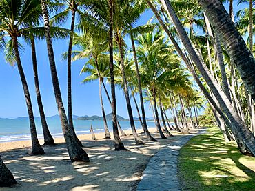
Palm trees at Palm Cove Beach, 2020
|
|||||||||||||||
| Population | 2,450 (2021 census) | ||||||||||||||
| • Density | 360/km2 (930/sq mi) | ||||||||||||||
| Postcode(s) | 4879 | ||||||||||||||
| Area | 6.8 km2 (2.6 sq mi) | ||||||||||||||
| Time zone | AEST (UTC+10:00) | ||||||||||||||
| Location |
|
||||||||||||||
| LGA(s) | Cairns Region | ||||||||||||||
| State electorate(s) | Cook | ||||||||||||||
| Federal Division(s) | Leichhardt | ||||||||||||||
|
|||||||||||||||
Palm Cove is a beautiful suburb located in Cairns, Queensland, Australia. It is famous for the many palm trees that grow along its beach. In 2021, about 2,450 people lived there.
Contents
Exploring Palm Cove's Location
Palm Cove is in Far North Queensland, right on the Australian coast. It has a long, sandy beach. Only a rocky area called Buchan Point breaks up the sand in the north.
Arlington Reef, a part of the amazing Great Barrier Reef, is only about 30 kilometers offshore. This reef helps keep the ocean waters near the beach calm and safe. To the west, you'll find the Macalister Range National Park. This park is part of the Wet Tropics World Heritage Area, a special place protected for its unique nature.
Because Palm Cove is in a tropical area, the weather is warm. In summer, temperatures are usually between 24 and 33 degrees Celsius. In winter, they are between 14 and 26 degrees Celsius.
A Look at Palm Cove's Past
Palm Cove is located on the traditional lands of the Djabugay (Tjapukai) Indigenous Australians.
The first time a British group explored this area was in 1873. This group was led by George Elphinstone Dalrymple. They stopped in Palm Cove and found a large lagoon.
Before World War I, in 1918, Albert Veivers bought the land that is now Palm Cove. He was important because he helped build the first road to Palm Cove. This road made the area more popular and helped it grow.
After World War II, Palm Cove became even more popular with travelers. It was used as a training base for Australian soldiers during the war.
In 1986, the Ramada Reef Resort opened. This was the first international hotel chain in Palm Cove. Since then, the area has become well-known around the world. In 2024, a travel magazine called Condé Nast Traveler named Palm Cove the "Best Beach in the World." They said it was a "tropical paradise."
How Many People Live Here?
- In 2006, Palm Cove had 1,215 residents.
- By 2016, the population grew to 2,059 people.
- In 2021, 2,450 people called Palm Cove home.
What Palm Cove's Economy Is Like
The main way people in Palm Cove earn a living is through tourism. Many jobs are in hotels, restaurants, and other services for visitors. In 2011, about 21% of people worked in these areas.
Schools Near Palm Cove
There are no schools directly in Palm Cove. Younger students usually go to Trinity Beach State School. Older students attend Smithfield State High School in Smithfield. Both schools are in nearby suburbs.
What You Can Find in Palm Cove
Palm Cove focuses on services for tourists. You can find convenience stores, a post office, and a pharmacy. There are also many cafes, bars, and restaurants. You can rent bicycles or scooters, and try different water sports. Shops sell clothes, swimwear, and gifts. For bigger shopping, people go to Clifton Beach.
Fun Things to Do in Palm Cove
Palm Cove is a great place for tourists. It's close to the Great Barrier Reef and the Daintree Rainforest. You'll find many resorts and apartments here.
The beautiful beaches and palm-lined paths are perfect for walking, jogging, and cycling. There are also safe swimming areas with nets and lifeguards. The Palm Cove jetty is a popular spot for fishing. Anglers often catch fish like mackerel and shark there.
Getting Around Palm Cove
The closest big airport is Cairns International Airport. The only main road to Palm Cove is the Captain Cook Highway. This highway connects Cairns in the south to Mossman in the north. Buses also connect Palm Cove to other nearby suburbs.
 | Jackie Robinson |
 | Jack Johnson |
 | Althea Gibson |
 | Arthur Ashe |
 | Muhammad Ali |


