
Clifton Beach, Queensland facts for kids
Quick facts for kids Clifton BeachCairns, Queensland |
|||||||||||||||
|---|---|---|---|---|---|---|---|---|---|---|---|---|---|---|---|

Clifton Beach, 2013
|
|||||||||||||||
_-_Map_1.jpg) _-_Map_2.jpg) Map of Clifton Beach in the Cairns Region
|
|||||||||||||||

Clifton Beach
Location in Queensland
|
|||||||||||||||
| Population | 3,192 (2021 census) | ||||||||||||||
| • Density | 414.5/km2 (1,074/sq mi) | ||||||||||||||
| Postcode(s) | 4879 | ||||||||||||||
| Area | 7.7 km2 (3.0 sq mi) | ||||||||||||||
| Time zone | AEST (UTC+10:00) | ||||||||||||||
| Location |
|
||||||||||||||
| LGA(s) | Cairns Region | ||||||||||||||
| State electorate(s) | Barron River | ||||||||||||||
| Federal Division(s) | Leichhardt | ||||||||||||||
|
|||||||||||||||
Clifton Beach is a lovely coastal area, or suburb, located in the Cairns Region of Queensland, Australia. In 2021, about 3,192 people called Clifton Beach home.
Contents
Exploring Clifton Beach's Location
Clifton Beach is found about 22 kilometres north of Cairns, right by the beautiful Coral Sea. To the west, you'll see the Macallister Range mountains, which border the Kuranda State Forest. Kewarra Beach is to the south, and Palm Cove is to the north. The main road, the Captain Cook Highway, goes right through Clifton Beach.
The Beach and Its Features
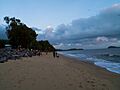
To the east, there's a long, sandy stretch of coastline called Clifton Beach. This beach can be quite narrow, especially at high tide. Special rock walls, called groynes, help protect it from being washed away by the ocean.
It's important to know that swimming at Clifton Beach can be risky. Sometimes, crocodiles visit the area. Also, during the first half of the year, tiny "stinger" jellyfish can be present. Touching them can be very painful and sometimes even dangerous. Luckily, in the northern part of the beach, there's a special swimming area protected by nets. This net helps keep both crocodiles and jellyfish out, making it safer for swimming. You can also find some barbecue spots there for a fun day out!
A Look Back at Clifton Beach's History
Clifton Beach is located on the traditional lands of the Djabugay (Tjapukai) Aboriginal people.
How Clifton Beach Got Its Name
The area was named by the local council. It might have been named after the birthplace of William Fairweather's wife, who was from Clifton, Queensland in southern Queensland. Another idea is that it was named after Clifton in Scotland, where an early settler named Mary Hunter Smart was born.
Clifton Beach officially became a suburb on May 2, 1959.
Growing Over the Years
In 1969, a post office opened in Clifton Beach. During the 1970s, more buildings were constructed, and roads were improved. By the 1980s, the area had trailer parks and a safe swimming spot. Clifton Beach was a mix of homes and holiday places, with a relaxed, rural feel.
Older houses and tourist spots from this time can still be seen along Arlington Esplanade, which runs along the beach. A community centre was built nearby, and local shops sold everyday items and crafts. A zoo, first called Wild World Zoo and later Cairns Tropical Zoo, opened on the Captain Cook Highway, bringing more visitors.
The number of people living in Clifton Beach grew a lot in the late 1980s. This growth continued into the 2000s. It became a popular suburb for many people, including retirees. The area between the highway and the beach became quite developed, while the land on the other side of the highway, closer to the Kuranda State Forest, remained mostly untouched.
A shopping centre was built on Captain Cook Highway. In 2004, it was expanded to include a large supermarket.
Who Lives in Clifton Beach?
In 2016, Clifton Beach had about 3,146 residents. By 2021, the population had grown slightly to 3,192 people.
Learning and Local Facilities
Clifton Beach does not have its own schools. For primary school, students usually go to Trinity Beach State School in Trinity Beach, Queensland. For high school, the closest option is Smithfield State High School in Smithfield, Queensland.
What's Available in Clifton Beach?
You can find the post office inside the Clifton Village Shopping Centre, which is on Captain Cook Highway. You can get there by using Endeavour Road.
There are also several parks in the suburb where you can relax and play:
- Eddy Street Park (16°45′52″S 145°40′15″E / 16.7645°S 145.6707°E)
- Edward Mann Park (16°46′11″S 145°40′34″E / 16.7696°S 145.6761°E)
Images for kids
-
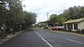
Arlington Esplanade, 2018
-
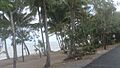
Arlington Esplanade with beach, 2018
-
Observers of a solar eclipse, around 2016
-
Holiday apartments on Arlington Esplanade, 2008

,_Clifton_Beach,_2018.jpg)

.jpg)
