Smithfield, Queensland facts for kids
Quick facts for kids SmithfieldCairns, Queensland |
|||||||||||||||
|---|---|---|---|---|---|---|---|---|---|---|---|---|---|---|---|

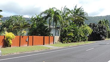
Looking west along Stanton Road, 2018
|
|||||||||||||||
| Population | 6,664 (2021 census) | ||||||||||||||
| • Density | 508.7/km2 (1,318/sq mi) | ||||||||||||||
| Established | 1876 | ||||||||||||||
| Postcode(s) | 4878 | ||||||||||||||
| Area | 13.1 km2 (5.1 sq mi) | ||||||||||||||
| Time zone | AEST (UTC+10:00) | ||||||||||||||
| Location |
|
||||||||||||||
| LGA(s) | Cairns Region | ||||||||||||||
| State electorate(s) | Barron River | ||||||||||||||
| Federal Division(s) | Leichhardt | ||||||||||||||
|
|||||||||||||||
Smithfield is a lively suburb located in the Cairns Region of Queensland, Australia. It's part of the bigger city of Cairns. In 2021, about 6,664 people called Smithfield home.
Contents
Where is Smithfield?
Smithfield is located about 15 kilometers (9 miles) north of Cairns City. Two important roads, the Captain Cook Highway and the Kuranda Range Road, meet here. These roads help people travel around the region.
Smithfield's History
Early Days
The land around Smithfield has a long history. The Irukandji people are the traditional owners of this area. Their language, also known as Yirrgay, was spoken around the Kuranda Range and Lower Barron River.
Smithfield was first set up in 1876. It was named after William "Bill" Smith, an explorer who had a camp here. For a while, Smithfield was a competitor to Cairns for being the main town in the area.
A New Start
However, a huge flood from the Barron River hit Smithfield in March 1879 during a cyclone. This flood was so bad that the original town site had to be abandoned.
Today, Smithfield is a busy suburb of Cairns. It has become the main business and shopping center for the "Northern Beaches" area of Cairns.
Schools and Library
- The first school, Smithfield Provisional School, opened on May 7, 1900.
- It later became Smithfield State School in 1909 but closed in 1964.
- Smithfield State High School opened its doors on January 24, 1983.
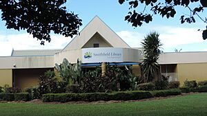
- The Smithfield library first opened in 1998. It was updated in 2008 to make it even better.
People of Smithfield
The number of people living in Smithfield has grown over the years:
- In 2011, there were 3,707 people.
- By 2016, the population grew to 5,303 people.
- In the most recent count in 2021, Smithfield had 6,664 residents.
Learning in Smithfield
High School Education
Smithfield State High School is a government school for students in Years 7 to 12. It's located on O'Brien Road. In 2018, the school had over 1,100 students and many teachers. It also has a special program for students who need extra support.
Primary Schools
There are no primary schools directly in Smithfield. However, nearby suburbs have schools for younger students:
- Caravonica State School is to the south.
- Trinity Beach State School is to the north.
- Yorkeys Knob State School is to the east.
University Campus
The Cairns Campus of James Cook University is also located in Smithfield. This means students can study a wide range of subjects right here in the suburb.
Community Facilities
Smithfield has many important services for its residents:
- Emergency Services: You can find the Smithfield Police Station, Fire Station, and Ambulance Station here. These are crucial for keeping the community safe.
- Health: The Smithfield Community Health Centre helps people with their health needs.
- Animal Care: The Animal Protection Society is also located in Smithfield, helping animals in need.
What Can You Do in Smithfield?
Library and Community Groups
The Cairns Regional Council runs the Smithfield library on Cheviot Street. It's a great place to read, study, or borrow books.
The Smithfield branch of the Queensland Country Women's Association (CWA) meets nearby. This group helps women in rural areas and supports the community.
Shopping and Services
Smithfield has two main shopping centers:
- Smithfield Shopping Centre: This is a large center on Captain Cook Highway. The Smithfield Post Office is also located inside this shopping center.
- Campus Village: This shopping center is on Faculty Close, across the highway from James Cook University.
Sports and Recreation
There are several places for sports and fun on Leisure Park Road:
- Marlin Coast Recreation Centre: A place for various activities.
- Marlin Coast Swimming and Fitness Centre: Perfect for swimming and staying fit.
- North Queensland Surf Lifesaving: Helps keep beaches safe.
- Ivanhoes Rugby League Club: A local club for rugby league fans.
Places of Worship
Northern Cairns Uniting Church is located on Cheviot Street.
Amazing Attractions
Skyrail Rainforest Cableway
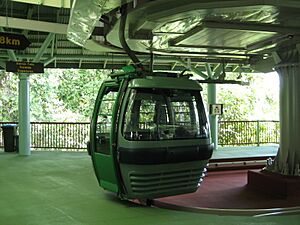
The starting point for the Skyrail Rainforest Cableway is in Smithfield. This amazing cableway takes you on a journey high above the rainforest. You'll glide through the Barron Gorge National Park all the way to Kuranda, which is at the top of the Great Dividing Range. It's a fantastic way to see the beautiful nature of the area!
Australian Armour and Artillery Museum
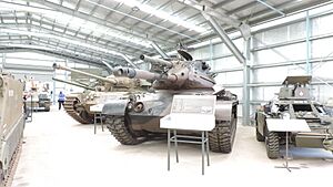
The Australian Armour and Artillery Museum is also in Smithfield. This museum has a huge collection of armored vehicles and artillery. They say it's the largest collection in the Southern Hemisphere! It's a fascinating place to learn about military history.
Tjapukai Aboriginal Cultural Park (Closed)
The Tjapukai Aboriginal Cultural Park used to be in Smithfield. It was a place where visitors could learn about the rich culture and traditions of the local Djabugay people. Unfortunately, the park closed in January 2021.
 | Misty Copeland |
 | Raven Wilkinson |
 | Debra Austin |
 | Aesha Ash |


