History of Cairns facts for kids
The history of Cairns in Queensland, Australia, shows how a small port grew into a modern city. It had a tough start because of competition from nearby Port Douglas. But big projects, new organizations, and being part of world events helped Cairns grow quickly.
Some key moments in Cairns' history include: building the Cairns-to-Herberton railway line in 1886, setting up the Cairns Harbour Board in 1906, becoming an official city in 1923, being used by military forces in World War II in 1942, building tall concrete apartments in 1981, opening the international airport in 1984, and creating a world-class convention centre in 1996.
Contents
Before Cairns Was Settled
Original Inhabitants
It's believed that Aboriginal people arrived in Australia at least 60,000 years ago. Many think they came through northern Australia, including Cape York Peninsula. Local Aboriginal stories tell of hunting and fishing on land that used to stretch beyond Green Island when sea levels were lower. Evidence shows Aboriginal people lived in the rainforest around Cairns for at least 5,100 years.
The first people recorded living in the Cairns area were Australian Aboriginal people. The Gimuy Walubara Yidinji language groups lived mainly south of the Barron River. North of the river, especially along the coast from the Barron to Port Douglas, Yirrganydji groups spoke different forms of the Djabugay language.
The Yidinji language is an Aboriginal language. Its traditional area includes parts of the Cairns Region and Tablelands Region, like Cairns and Gordonvale. The Cairns area is known as Gimuy in the local Yidinji language.
Early European Explorers
On June 10, 1770, English explorer Lieutenant James Cook visited the area. He named the bay Trinity Bay because he found it on Trinity Sunday. Cook brought his ship, the HM Bark Endeavour, into Mission Bay. He went ashore briefly with Sir Joseph Banks near where the Yarrabah Aboriginal community is today.
Lieutenant Phillip Parker King was an important early mapmaker of Australia's coast. He made three trips to northern Australia in 1819, 1820, and 1821. On all three trips, he visited Fitzroy Island, which is about 22 km (14 mi) from Cairns. King noted that there was drinking water and Aboriginal people in the area.
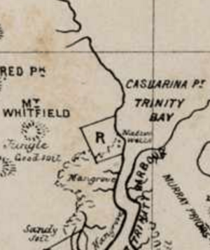
In June 1848, Captain Owen Stanley spent ten days mapping the depths of Trinity Bay. His official map showed "Native Huts" at today's Palm Cove. It also marked "Many Natives" and a "Native Village" along the coast just north of there. The future site of Cairns was marked as "Shoal" and "Mangroves."
Cairns Settlement Begins
Choosing the Site
An important step towards Cairns being settled was an article published in a Sydney newspaper in 1866. It was written by J. S. V. Mein, who was setting up a bêche-de-mer (sea cucumber) business at Green Island. This article helped people in the south learn more about this northern area.
When the beche-de-mer fishermen arrived in the late 1860s, the British started to have a presence in the area. On the site of what is now the Cairns foreshore, there was a large well used by these fishermen. In 1872, there was a fight between local Yidinji people and a fisherman named Phillip Garland over this well. After this, the area was called Battle Camp.
In 1872, William Hann led a group looking for gold in the Palmer River. A large gold field was found there. When James Venture Mulligan announced this in September 1873, many gold prospectors came. This was the start of the first large non-Indigenous populations in Far North Queensland.
In March 1876, James Mulligan announced an even bigger gold field at the Hodgkinson River on the Atherton Tableland, about 122 km (76 mi) west of Trinity Inlet. This discovery was so big that people seriously considered building a track to the coast. They also wanted to set up a port and settlement to export the gold. Sub-Inspector Alexander Douglas-Douglas of the Native Police led a group to cut a track from the tableland to the coast. He met up with another Sub-Inspector, Robert Arthur Johnstone, and the track was finished on September 23, 1876. It was later named the Douglas Track.
Official Settlement
Around the same time, another group led by William "Bill" Smith found a different route to the coast at Trinity Inlet. This was called Smith's Track, and where it ended on the inlet was called Smith's Landing. After more investigation, Trinity Inlet was seen as a good place for a port. Brinsley G. Sheridan, a police magistrate, surveyed the area around Smith's Landing and planned a settlement called Thornton. However, the coastal site of Battle Camp, where the more direct Douglas Track ended, became the preferred place for the settlement.
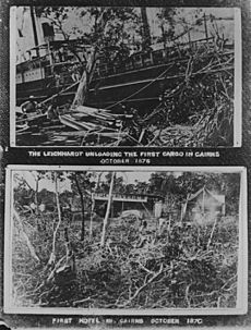
The first government officials arrived by boat and set up their tents. On October 7, 1876, the Governor of Queensland, William Wellington Cairns, officially declared the new northern port at Trinity Bay. It was named Cairns in his honor. On November 1, 1876, the town was officially started. This is seen as the official birth date of Cairns. The first public land sales happened in February 1877. Three months later, the first local saw mill was built, using the area's rich timber. The Smith's Landing-Thornton area later became part of the Cairns suburb of Portsmith.
Early Development
For five years, Cairns faced competition from the older town of Port Douglas and nearby Smithfield. But Cairns became stable thanks to successful farming by Chinese business people and workers. Three Englishmen, George Clayton, Thomas Hill, and Thomas Swallow, developed thousands of acres of farms south and east of Cairns. By 1885, there were enough people and organization for Cairns to become a municipality. Its first mayor, R. A. Kingsford, was elected.
Building a railway line from Cairns to Herberton in 1886 brought many immigrant workers, mostly Italian and Irish, to the area. These new residents needed land for farming. Sugar cane was grown on the lowlands, and fruit and dairy farms were on the tableland. This made Cairns more important as a regional center. The town leaders decided to improve street lighting, which was a luxury at the time.
In April 1887, the second part of the railway line began, from Redlynch to Myola. Many worker camps and hotels were set up near the fifteen tunnels needed for the line. The site for the village of Kuranda, the first large area suitable for development at the top of the range, was surveyed in 1888.
In 1891, A. J. Draper became mayor of Cairns. He was the most important political figure in early Cairns history, serving seven terms. Draper fought hard for public improvements, bringing many benefits to the community. Another important early activist was Church of England minister Ernest Gribble. He continued his father's work to help the local Aboriginal people. They were forced to live in camps after their traditional lands were taken by new settlers. In December 1893, thirty Aboriginal people arrived at Gribble's outstation looking for a safe place. This is seen as the unofficial start of the Yarrabah mission settlement.
By the late 1800s, the local Chinese community was producing huge amounts of rice, corn, bananas, and pineapples. The Cairns-Mulgrave Tramway was built from Cairns to Mulgrave in 1897. This connected areas south of Cairns to the port. A local natural gas company started in 1899, making homes more comfortable. In 1900, the importance of protecting the natural environment around the Barron Falls was recognized. The government made 30 square kilometers (7,400 acres) a national park.
Cairns Becomes a Town
In 1903, Cairns was officially declared a town, with about 3,500 people. That same year, the memories of R. A. Johnstone were published. These writings, later called Spinifex and Wattle, shared details of many Aboriginal customs Johnstone saw in the Trinity Bay and Barron River area in 1872–1873. After much public discussion, a local harbor board was set up in 1906. This led to a quick increase in new and creative buildings. Many of these are now heritage listed, like the Bolands Centre and St Monica's school.
In 1909, The Cairns Post newspaper started publishing six days a week, which it still does today. (An earlier newspaper with the same name was published from 1883 to 1893).
The town's first water supply opened in 1911. It was called "a valuable aid to sanitation" by the local newspaper. In July 1912, the brick and timber Cairns District Hospital opened. This helped the town handle medical emergencies on its own, especially in a tropical climate. The two-story building took two years to build and replaced an older, simpler hospital. The early 1900s also saw the growth of Malay Town near Alligator Creek, which became a hub for the area's first migrants.
Cairns Becomes a City
After World War I
World War I caused shortages of workers and goods for Cairns, which was physically isolated. After the war, there was a time of rebuilding and steady growth. On October 12, 1923, the government officially approved Cairns to be listed as a city.
The opening of the Daradgee Bridge near Innisfail in 1924 further connected Cairns to the rest of Australia. In 1925, public electricity supply was introduced, and the Cairns High School and Technical College opened. In 1926, The Cairns Post celebrated the settlement's 50th birthday with a special historical essay and photo supplement.
In 1927, Cyclone Willis caused widespread damage in Cairns. The large Glen Boughton estate, which had dairying, timber, and farms across the inlet from Cairns City, never recovered. The city's first Council Chambers opened in 1930. Sir Charles Kingsford Smith, a famous aviation pioneer and grandson of Cairns' first mayor, visited by plane in 1932.
The South American cane toad was brought to sugar cane fields south of Cairns in early 1935. It was meant to control the cane beetle. However, this toxic animal became one of Australia's worst pests, causing great harm to many native animals. In November of the same year, the Barron Falls Hydro Electricity scheme began providing power for a time of major industrial growth.
The city's first commercial radio station, 4CA, started in 1936. This helped reduce the feeling of isolation during the wet season. Heavy rain from a cyclone in early 1939 caused big floods on the Barron River. The floods changed the river's path, and its mouth moved north from Casuarina Point to Ellie Point.
World War II Impact
The start of World War II in 1939 increased the need for a good road to the tableland via Kuranda. This was for an emergency escape route if there was an invasion. This road, built in 18 months with one bulldozer, opened in June 1942.
During the Pacific part of World War II in 1942, Cairns was used by the Allied Forces. The United States, in particular, stationed troops in the region to supply its Pacific fleet. When Singapore fell, many local residents quickly left for the south. Many homes were sold cheaply, and a year later, the local population had dropped by nearly 7,000 people. Even after the war ended in 1945, many who left never came back.
Between 1943 and 1946, the Australian Army did a lot of testing with anti-malaria drugs. This work helped clear Cairns of many mosquito breeding areas, which were the cause of many fever outbreaks. It also greatly improved knowledge about controlling and treating tropical insect-borne infectious diseases.
After World War II Recovery
In August 1946, a two-week series of auctions for old army equipment attracted buyers from all over Australia. They wanted to buy goods like textiles and building equipment, which were in short supply. In September 1947, the corvette HMAS Warrnambool was badly damaged when it hit a sea mine. Three crew members died, and 86 were injured. This showed the danger of the mines. By 1948, the official minesweeping group stopped its work after collecting over 2,000 mines and clearing the shipping lanes.
In 1949, long-time Cairns Mayor, William Collins, lost the local council elections to Australian Labor Party candidate W. H. Murchison. This ended Collins' record 22 years in office. To make Cairns more accessible, a second plane service, Trans Australia Airlines, joined Australian National Airways for regular domestic flights in 1949.
A second radio station, ABC 4QY, started broadcasting in 1950. To restart local industry and reach a wider market for tableland fruit, a tropical fruit cannery, Amberglow, opened in December 1950. It was in the Smiths Creek area, in a former navy store. The cannery was successful at first but closed in 1957 due to financial problems. Dredging of the harbor, which had stopped during the war, started again in the 1950s.
In September 1951, Cairns' second hospital, the Calvary Hospital, opened. It was run by a Catholic nursing group, the Sisters of the Little Company of Mary. In October, the city's 75th anniversary "Back to Cairns" celebrations created a new sense of pride in local achievements. A large parade with over 100 floats showed the historical and industrial progress of Cairns and the surrounding area over the past 75 years.
Cultural Growth
Several years of big improvements for tourist facilities and advertising followed. It started with the 1953 release of There's A Future For You in Far North Queensland, a film made by local Cairns printer, Bob Bolton. This film was well-received and shown for many years in London at the British Office of Immigration. Starting in June 1953, an air-conditioned tourist train, The Sunlander, arrived weekly from Brisbane. This encouraged vacationers from the south.
Queen Elizabeth’s visit to Cairns in March 1954 was very popular. An estimated 40,000 people attended, which was twice the official population. This showed their loyalty to the British monarch. Scenes of Cairns were shown a lot in the official film of the Queen's visit to Australia. This made the area more known internationally. At the same time as the royal tour movie, Bob Bolton released the first North Queensland tourist guide. In October 1954, the city's water supply was improved with the addition of the Behana Creek intake. In May 1955, the Italian migrant worker ship, Flaminia, arrived. It brought European influences and culture, and a new generation of much-needed farming families. In August, a modern steel-framed railway station replaced the old wooden and rusty iron one.
In 1956, Cyclone Agnes hit Cairns with winds of 110 km/h (68 mph). Although there was a lot of damage to plants and property, the effect was much less because it was a 'dry' cyclone with little or no rain.
Towards the end of the year, the 16th Olympic games were held in Melbourne, Australia. In November, the Olympic torch arrived in Cairns from Darwin. It was carried first by Constantine Verevis, an Australian-born Greek, and then by Anthony Mark, a North Queensland runner chosen to represent the Aboriginal people of Australia.
Parts of a Cinerama movie, Cinerama South Seas, were filmed in Cairns in 1957. This three-screen color movie revisited the places James Cook saw during his sea voyages 187 years before. Showing a Cinerama documentary was seen as a big boost for the tourism of any region it showed.
Better Infrastructure
In 1958, the Cairns Council started a much-needed sewering project for the entire city. This provided the basic plumbing for future growth. In September 1958, a small team of volunteers created the Cairns Historical Society. Their goal was to encourage collecting and sharing Cairns' history. An official tourist area was declared on August 4, 1960. The opening of a new Green Island jetty in 1962 started the first annual Cairns Tourist Festival, which was renamed Fun in the Sun the next year.
In December 1962, an all-weather radar and cyclone-warning station opened at Saddle Mountain, near Kuranda. It was controlled remotely from Cairns Airport. This station was needed to cover a blind spot in the Townsville warning system. In 1963, the Barron Gorge Hydroelectric Power Station started working. It was connected to Townsville and Mackay, greatly increasing the available electricity for homes and industries. A bulk sugar terminal opened on the Cairns waterfront in October 1964. This ensured that the region's sugar industry would continue to be important.
Continued Growth
The first issue of Bob Bolton's glossy color tourism magazine, The North Queensland Annual, in 1966 was a big step for promoting the local area. Later that same year, the first local television stations started broadcasting: ABC 9 in July and FNQ 10 in September. In October, the city's first independent newspaper since the 1930s, The Northerner, began publishing. It continued until April 1968.
In 1969, Percy Trezise published a well-known book about the Quinkan Aboriginal cave paintings of Cape York Peninsula. These ancient paintings, long known to local residents, soon became a topic of discussion across Australia and internationally.
In 1970, the City Council became the first local council in Queensland to get a Burroughs mainframe computer. It was the size of a large home freezer and had a memory of "200 words."
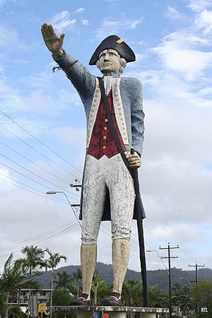
In 1972, a group of young people started a hippie community at Weir Road, Kuranda, near Barron Falls National Park. The commune lasted only a few years. Some members later rejoined society and became local tourism figures. In October 1972, the new Captain Cook motel, known for its huge and debated statue of Captain Cook, started advertising daily. The Council accidentally approved the statue's construction because an officer didn't realize its proposed height was given in metric units, not imperial feet and inches.
The Royal Australian Navy had a presence in Cairns, operating a Patrol Boat Facility. In 1973, it was officially named HMAS Cairns. A new base was built, which is still in use today. The old naval wharf became the construction site of Trinity Wharf.
The long-awaited Cairns Civic Center was officially opened by Australian Prime Minister Gough Whitlam on May 31, 1974. Mr. Whitlam said that Cairns was unique because it could combine ideas and styles from three cultures: European, Aboriginal, and Torres Strait Islander. In February 1975, local person Emrys "Rusty" Rees took over a loosely organized 'hippie' market. He founded Rusty's Markets on the site of old Chinese produce markets from the 1800s.
1976 saw the start of water supply from Copperlode Falls Dam. This provided the extra water needed for a predicted rapid increase in population. Later that same year, Cairns celebrated its 100th anniversary with various public events. Dorothy Jones published the book, Trinity Phoenix, which is considered the first serious and complete history of Cairns.
Building two modern bridges at Stratford and Kamerunga in 1977 and 1980 helped ease serious traffic problems between Cairns and the Northern Beaches during the wet season. In 1979, the Cairns public library opened. The opening of Ruth's Women's Shelter second-hand book shop in November 1980 was a practical way to provide a vital community service. Staffed by volunteers, it sold donated books to raise money for setting up and running a women and children's crisis accommodation shelter.
Modernisation
A big step in making Cairns modern was building four tall apartment and hotel buildings between 1981 and 1983. Some builders thought this type of architecture was not suitable for Cairns, but it marked the start of the local high-rise era. During this time, the Queensland Government decided to issue two casino licenses, one for the north and one for the south. There were three major proposals from developers in Cairns. Most people in Cairns were against these proposals and protested. The government chose Townsville's proposal for a casino.
There was a lot of media attention on the long conflict with protesters in December 1983 when bulldozers cut a track for a road through Cape Tribulation rainforest. In August 1984, construction of the actual road began. The debated road opened in October 1984. A major long-term benefit for Cairns was the opening of Cairns International Airport in 1984. This gave international travelers direct access to Cairns and the surrounding region.
The 1987 founding of the Tjapukai Dance Theatre in Kuranda greatly benefited Cairns' tourism and the cultural pride of the local Indigenous population. The same year, also at Kuranda, a butterfly sanctuary opened. It was later named the largest on Earth by the Guinness Book of Records.
Two events in 1988 increased Cairns' reputation for natural beauty and scientific interest. In February, a long boardwalk through the mangrove swamps near Cairns airport opened. This allowed visitors to experience the natural environment that surrounded the first Aboriginal and European settlers. In December, wet tropical rainforest between Cooktown and Townsville was added to the World Heritage list.
Sugarworld Waterpark was developed by Colonial Sugar Refineries (CSR) and first built at Hambledon Estate. It officially opened on September 9, 1989. In 1995, the land and waterslide facilities became the property of the Cairns City Council. Today, the land is leased and operated by a private company.
In 1990, the city's mail sorting facilities and central post office boxes were moved. In 1992, a new multi-story courthouse and police station were built. They cost $46.5 million and were built to handle the legal needs of the quickly growing North Queensland population. In early 1993, local chiropractor Harald Falge created the Street Level Youth Care organization. It was run by volunteers to help the homeless with food, blankets, and other needs.
In 1994, construction began for the 7.5 km (4.7 mi) Sky Rail scenic cableway from Cairns to Kuranda over World Heritage rainforest. It opened in 1995, further promoting ecotourism in the region. In 1995, the Mulgrave Shire and Cairns City councils joined to form the current City of Cairns. That same year, a $1.5 million Art Gallery and Cairns' first public Internet café opened. Also, James Cook University officially opened a campus at Smithfield.
The opening of the 100,000 square meter (25 acre) $8.8 million Tjapukai Aboriginal Cultural Park in July 1996 helped promote education and understanding of Australian Aboriginal culture. The theme park received many awards. Tjapukai closed in January 2021. Construction of the Cairns Convention Centre began in the same month. This was an important step towards hosting modern corporate events. The center's first major conference in 2000 was presented by the software giant, Microsoft. At the suggestion of the Cairns City Council, an annual Reef Festival was first held in October 1996. It combined the resources of the city's main festival, Fun in the Sun, with other smaller festivals.
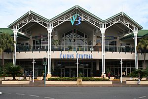
In May 1996, the old brick Cairns Railway Station (built in 1960) was torn down. The site was redeveloped into Cairns Central Shopping Centre, which included the new railway station. A new Cairns City Council Chambers opened in 1998. The City Library moved into a renovated version of the previous Council Chambers building in 1999.
In May 2000, a ten-year battle ended between the Queensland State Government and a private developer. The developer had planned to build a $1.2 billion resort on East Trinity, across Trinity Inlet from Cairns City. The dispute was solved when the land was bought for the state. In June 2000, Australia hosted the Olympic Games again. During the North Queensland part of the Olympic torch relay, there was a lot of worldwide television and print media attention. This was because the 27th Olympic torch was carried on a Skyrail cable car by Djabugay Aboriginal elder Martha "Cookie" Brim. Then it was carried underwater over the Great Barrier Reef by Australian marine biologist Wendy Craig Duncan.
Cairns in the 21st Century
2002 saw the start of the annual Cairns Festival. This included activities from the previous Reef and Dive festivals. In March 2003, a public swimming lagoon and Esplanade foreshore boardwalk were officially opened. This gave Cairns City a small area of white sandy beach.
In 2004, the Cairns Convention Centre was named the world's best congress center by the International Association of Congress Centers. In the same year, the local Djabugay rainforest Aboriginal group was given native title over Barron Gorge National Park. This was the first such claim recognized in Queensland, and the first in Australia granted outside of court. In 2005, the Japanese company, Daikyo, stopped its operations in North Queensland due to economic problems elsewhere. This ended 17 years of major tourism investment in the Cairns area, including a $30 million upgrade of facilities at Green Island.
On April 24, 2006, the Yarrabah-based Mandingalbay Yidinji people became the second Aboriginal group in Queensland, after the Djabugay, to have their traditional lands recognized. This recognition by the Australian Government took 12 years to be approved. It happened 236 years after British explorer Captain James Cook briefly visited the Yarrabah area.
In December 2023, Cairns had record flooding caused by Cyclone Jasper. The Barron River rose higher than its March 1977 record of 3.8 meters (12.5 feet). This made it the worst flooding event in Cairns since records began in 1915.
 | Aurelia Browder |
 | Nannie Helen Burroughs |
 | Michelle Alexander |


