
Atherton Tableland facts for kids
The Atherton Tableland is a very fertile plateau in Queensland, Australia. It's part of the huge Great Dividing Range. This area is quite large, covering about 64,768 square kilometres, and around 45,000 people live there. The biggest towns on the Atherton Tableland are Mareeba and Atherton. Other smaller towns include Tolga, Malanda, Herberton, Kuranda, Ravenshoe, Millaa Millaa, Chillagoe, Dimbulah, Mt Garnet, Mt Molloy, Tinaroo and Yungaburra.

The main river flowing through this plateau is the Barron River. It was dammed to create a large water storage area called Lake Tinaroo, which is used for irrigation. Near the dam, there's a small power station called Tinaroo Hydro that uses water to make electricity.
Contents
Understanding the Land: Geography
The Atherton Tableland is a special part of the North Queensland Highlands. This whole area is part of the larger Great Dividing Range, which is a long chain of mountains and plateaus along Australia's east coast. South of the Tablelands, you'll find the Bellenden Ker Range.
How the Land Was Formed
About 100 million years ago, the eastern edge of Australia was much wider. Then, huge forces deep inside the Earth caused the land to break apart. As the eastern part slowly sank into the ocean, the western part lifted up. This lifting and sinking created a steep drop-off called the Great Escarpment, which separates the flat coastal areas from the higher tablelands.
From over 4 million years ago until about 10,000 years ago, many volcanoes erupted across the Atherton Tablelands. The oldest eruptions created wide, gently sloped volcanoes that poured out lots of lava. This lava filled up old valleys, making the land much flatter than it was before.
Around one million years ago, the eruptions changed. The lava became gassier, throwing bits of rock and lava into the air. This built up many small, cone-shaped hills called scoria cones, like the Seven Sisters near Yungaburra. Sometimes, rising hot magma hit underground water, causing huge, explosive eruptions. These explosions created bowl-shaped hollows called maars, which later filled with water to become beautiful lakes like Lake Eacham and Lake Barrine. Even though these volcanoes are now considered extinct, they were active quite recently, so it's possible that new eruptions could happen in the future.
A Look Back: History
The Atherton Tableland has a very long history of Aboriginal people living there. Their traditional ways of life and culture have been recorded since Europeans first arrived. Today, Aboriginal people connected to this region are still working to keep their culture strong, even after a long period when they were forced to leave their lands after European settlement in the late 1800s and early 1900s.
The Yidinji language is an Aboriginal language traditionally spoken in areas like Cairns, Gordonvale, and the southern part of the Atherton Tableland, including Atherton and Kairi.
Dyirbal is another Aboriginal language from Far North Queensland. It was spoken around Tully and the Tully River area, extending to the Atherton Tablelands.
A European explorer named J.V. Mulligan first explored the Atherton area in 1875. In 1877, John Atherton settled near the town that now carries his name. The area was first explored because people thought there might be valuable minerals there, and they found deposits of tin and gold. Atherton Creek is also named after John Atherton.
The town of Herberton was started on April 19, 1880, by John Newell to mine the tin he found. Mining began just a few weeks later. By September of that year, Herberton already had a population of 300 men and 27 women!
In the late 1800s, the Mulligan Highway was built through the hills from Herberton, passing through what is now Main Street in Atherton, and continuing down to Port Douglas. This road was used by the famous Cobb and Co coaches to travel to Western Queensland. At its busiest, Herberton was the richest tin mining area in Australia.
Industries and Development
John Atherton, who was originally a farmer, was the first to find tin deposits in Herberton in 1880. A local story says that Tinaroo Creek got its name because Atherton shouted, "Tin! Hurroo!" when he made his discovery. This discovery led to many miners rushing to the area.
After tin, another important industry was timber. A road was built, bringing in timber cutters who harvested valuable trees like red cedar, kauri, maple, black bean, and red tulip oak. These timbers were used for buildings.
Before the town of Atherton grew, a large Chinatown appeared. Many Chinese people moved to the Atherton area from the Palmer River Goldfields after the big timber stands were cleared for farming. The Chinese were very important in starting agriculture in North Queensland. They grew 80% of the crops on the Tablelands and helped open up the area for settlement. After crops, they also started dairying. As Chinatown grew, it had shops, wells for water, cooks, herbalists, doctors, and merchants. The simple straw huts were replaced by wooden houses with verandahs and iron roofs. By 1909, Chinatown was the largest gathering of Chinese people on the Tablelands, with 1100 residents. Today, the Hou Wang Temple is one of the few remaining reminders of the Chinese community in the Atherton Tablelands.

During the Second World War, Australian soldiers camped around the district before going to the front lines and again when they returned. Many soldiers are buried at the war cemetery in Atherton.
Today, many different crops are grown in the Atherton area. These include bananas, sugarcane, corn, avocados, strawberries, macadamia nuts, and mangoes, as well as citrus fruits. Farming dairy cows, raising other animals, and poultry farming are also important industries on the Tableland.
Fun for Visitors: Tourism
Tourism is the second biggest part of the Atherton Tablelands economy. The Tinaroo Dam and its many trails are a major attraction for visitors.
Towns to Explore
Atherton and Mareeba are the largest towns in the area. Other towns on the Atherton Tablelands include Herberton, Kairi, Kuranda, Malanda, Millaa Millaa, Tinaroo, Tolga, Yungaburra, Chillagoe, Walkamin and Ravenshoe.
Nature and Wildlife: Environment
The tableland has several small parts of the rainforest that used to cover the whole area. Many of these rainforest patches are now protected in national parks. This area is considered an Important Bird Area by BirdLife International because it's home to more than 1% of the world's population of the sarus crane and many bush stone-curlews.
There are also twelve special bird species that live only in this area and the mountains just south of it. These include the Atherton scrubwren, Bower's shrikethrush, bridled honeyeater, chowchilla, fernwren, golden bowerbird, grey-headed robin, Macleay's honeyeater, mountain thornbill, pied monarch, tooth-billed bowerbird and Victoria's riflebird.
Cool Places to Visit
- Lake Barrine
- Lake Eacham
- Curtain Fig Tree near Yungaburra.
- Undara Volcanic National Park
- Hann Tableland National Park
- Mount Hypipamee Crater and Dinner Falls
- Herberton
- Kuranda
- Chillagoe
- Mareeba
- Atherton
Images for kids
-
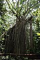
Curtain Fig Tree, Atherton Tableland
-
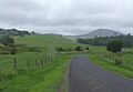
Country road to the Cathedral Fig Tree in the Atherton Tablelands
-
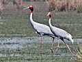
The area supports an important population of sarus cranes
-
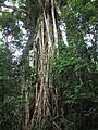
Cathedral Fig Tree near Lake Barrine. Not to be confused with the Curtain Fig Tree at Yungaburra.


_at_Sultanpur_I_Picture_151.jpg)

See also
 In Spanish: Meseta Atherton para niños
