Cairns Region facts for kids
Quick facts for kids Cairns RegionQueensland |
|||||||||||||||
|---|---|---|---|---|---|---|---|---|---|---|---|---|---|---|---|

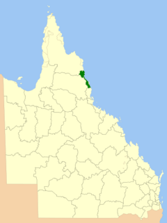
Location within Queensland, 2013, prior to de-amalgamation of Shire of Douglas
|
|||||||||||||||
| Population | 166,943 (2021 census) (38th) | ||||||||||||||
| • Density | 98.841/km2 (256.00/sq mi) | ||||||||||||||
| Established | 2008 | ||||||||||||||
| Area | 1,689 km2 (652.1 sq mi) | ||||||||||||||
| Mayor | Amy Eden | ||||||||||||||
| Council seat | Cairns City | ||||||||||||||
| Region | Far North Queensland | ||||||||||||||
| State electorate(s) | Barron River, Cairns, Cook, Hill, Mulgrave | ||||||||||||||
| Federal Division(s) | |||||||||||||||
 |
|||||||||||||||
| Website | Cairns Region | ||||||||||||||
|
|||||||||||||||
The Cairns Region is a special area in Far North Queensland, Queensland, Australia. It's like a big local community area, with the city of Cairns at its heart. It was created in 2008 when three smaller areas – the City of Cairns and the Shires of Douglas and Mulgrave – joined together.
However, after people spoke up and voted in 2013, the Shire of Douglas became its own separate area again on January 1, 2014.
The Cairns Regional Council, which manages the area, had a budget of about A$433.5 million for 2023-24. In 2021, about 166,943 people lived in the Cairns Region.
Contents
History of the Cairns Region
First Peoples of the Land
Before European settlement, the Cairns Region was home to many Aboriginal groups. Two important language groups are the Yidinji and Tjapukai peoples.
- The Yidinji people have traditional lands that include places like Cairns City, Gordonvale, and parts of the Atherton Tableland. Their language is called Yidinji.
- The Tjapukai people's traditional lands and language are found north of the Barron River. Their country stretches west towards Mareeba and north towards Douglas Shire.
These groups have lived on and cared for this land for thousands of years, and their culture and history are a very important part of the Cairns Region.
How the Region Grew
For a long time, the Cairns area was made up of different local government areas. These included the City of Cairns, the Shire of Douglas, and the Shire of Mulgrave.
Over the years, these areas changed and sometimes joined together. For example, the City of Cairns started as a small town in 1885 and grew into a city. The Shire of Mulgrave also grew by adding parts of other areas.
In 1995, the Shire of Mulgrave joined with the City of Cairns to form a larger City of Cairns. Then, in 2008, the City of Cairns and the Shire of Douglas joined to create the new Cairns Region. This was done to make local government more efficient.
But some people in the Douglas Shire wanted to be separate again. After a vote in 2013, the Douglas Shire became its own local government area once more on January 1, 2014. This means the Cairns Region now covers a slightly different area than it did right after 2008.
Towns and Localities
The Cairns Region is made up of many towns and smaller areas called localities. Here are some of them:
|
Cairns Central Area:
|
Northern Mulgrave Area:
|
Southern Mulgrave Area:
|
|
1 – shared with Cassowary Coast Region
2 – shared with Cassowary Coast Region and Tablelands Region
Libraries in the Region
The Cairns Regional Council runs several public libraries. These libraries are great places to find books, learn new things, and use computers. You can find them in:
- Babinda
- Cairns City
- Earlville
- Edmonton
- Gordonvale
- Manunda
- Smithfield
- Stratford
Population Over Time
The population of the Cairns Region has grown a lot over the years. The table below shows how many people lived in the area at different times. Before 2008, the numbers show the populations of the separate areas that later joined to form the Cairns Region.
| Year | Total Region | Cairns (City) | Mulgrave (Shire) | Douglas (Shire) |
|---|---|---|---|---|
| 1933 | 25,197 | 11,993 | 10,303 | 2,901 |
| 1947 | 29,622 | 16,644 | 10,485 | 2,493 |
| 1954 | 37,597 | 21,020 | 13,477 | 3,100 |
| 1961 | 42,985 | 25,204 | 14,427 | 3,354 |
| 1966 | 45,927 | 26,696 | 15,312 | 3,919 |
| 1971 | 51,345 | 30,288 | 16,985 | 4,072 |
| 1976 | 62,628 | 34,857 | 23,025 | 4,746 |
| 1981 | 76,388 | 39,096 | 31,335 | 5,957 |
| 1986 | 91,688 | 42,227 | 41,711 | 7,750 |
| 1991 | 116,584 | 49,361 | 54,783 | 12,440 |
| 1996 | 129,698 | 116,718 | 12,980 | |
| 2001 | 133,903 | 119,937 | 13,966 | |
| 2006 | 150,484 | 136,460 | 14,024 | |
| 2011 | 167,355 | 156,169 | 11,186 | |
| 2016 | 156,901 | |||
| 2021 | 166,943 | |||
The only time the Cairns Region included the Douglas Shire in a census was in 2011. In 2021, the Cairns Region had a population of 166,943 people.
How the Council Works
| Cairns Regional Council | |
|---|---|
 |
|
| Type | |
| Type | |
| Leadership | |
|
Mayor
|
Amy Eden, team eden team eden
|
|
Deputy Mayor
|
Brett Olds, Independent
|
| Structure | |
| Seats | 10 elected representatives, including a Mayor and 9 councillors |
|
Political groups
|
|
| Elections | |
|
Last election
|
16 March 2024 |
|
Next election
|
25 March 2028 |
The Cairns Regional Council is like the local government for the Cairns Region. It has a Mayor and nine councillors who are elected by the people living in the area. They make decisions about local services, like roads, parks, libraries, and rubbish collection.
- The Mayor is the main leader of the council.
- The councillors represent different parts of the region, called "divisions."
After the Douglas Shire became separate again in 2014, Julia Leu stopped being a councillor for the Cairns Region. In 2023, Bob Manning, who was the Mayor, retired, and Terry James became the new Mayor for a short time.
Who is on the Council Now?
The current council was elected in 2024. Here are the people who represent the Cairns Region:
| Ward | Councillor | Party | |
|---|---|---|---|
| Mayor | Amy Eden | team eden
team eden |
|
| Division 1 | Brett Moller | Cairns Unity | |
| Division 2 | Matthew Tickner | Independent LNP | |
| Division 3 | Cathy Zeiger | Independent | |
| Division 4 | Trevor Tim | team eden
team eden |
|
| Division 5 | Rob Pyne | independent greens qld
independent greens qld |
|
| Division 6 | Kristy Vallely | Cairns Unity | |
| Division 7 | Anna Middleton | Independent | |
| Division 8 | Rhonda Coghlan | Cairns Unity | |
| Division 9 | Brett Olds | Independent | |
 | Percy Lavon Julian |
 | Katherine Johnson |
 | George Washington Carver |
 | Annie Easley |

