Manoora, Queensland facts for kids
Quick facts for kids ManooraCairns, Queensland |
|||||||||||||||
|---|---|---|---|---|---|---|---|---|---|---|---|---|---|---|---|

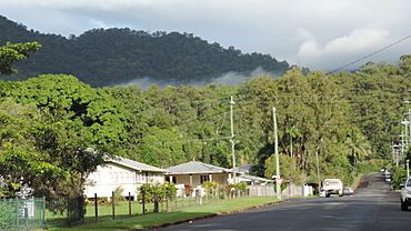
Macilwraith Street, looking west, 2018
|
|||||||||||||||
| Population | 6,175 (2021 census) | ||||||||||||||
| • Density | 2,810/km2 (7,300/sq mi) | ||||||||||||||
| Postcode(s) | 4870 | ||||||||||||||
| Area | 2.2 km2 (0.8 sq mi) | ||||||||||||||
| Time zone | AEST (UTC+10:00) | ||||||||||||||
| Location |
|
||||||||||||||
| LGA(s) | Cairns Region | ||||||||||||||
| State electorate(s) | Cairns | ||||||||||||||
| Federal Division(s) | Leichhardt | ||||||||||||||
|
|||||||||||||||
Manoora is a lively suburb located in Cairns, a city in Queensland, Australia. It's part of the wider Cairns Region. In 2021, about 6,175 people called Manoora home.
Contents
Exploring Manoora's Location
Manoora is found west of the Cairns city centre. This area is part of Far North Queensland. A main road, the Cairns Western Arterial Road, runs through the suburb.
Manoora's Past: A Look at History
Manoora is located on the traditional lands of the Yidinji Aboriginal people. They are the original custodians of this area.
How Manoora Got Its Name
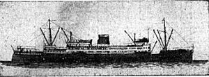
The suburb of Manoora was officially created in 1975. It was formed from parts of Parramatta Park and an area once known as West Cairns. The name "Manoora" comes from a ship called HMAS Manoora. This ship was named after a town in South Australia.
The HMAS Manoora was built in Scotland in 1935. It started as a coastal steamer, carrying goods and people. The ship often visited Cairns. During World War II, it joined the Royal Australian Navy to help with the war effort.
Community and Education Initiatives
In 2015, a group called Pau Enterprises Indigenous Corporation was started. They work to manage and protect the traditional lands of the Pau family on Darnley Island. They also help create businesses and support for community members who have moved to places like Cairns. Their office in Manoora helps with these projects.
A special school, Holy Spirit College, was approved in 2012. The Queensland Government provided $9 million to help build it. Construction began in July 2014 in Manoora and Cooktown. The Manoora campus opened its doors in 2015, even while construction was still finishing up.
Population Growth in Manoora
The number of people living in Manoora has grown over the years.
- In 2011, there were 5,688 people.
- By 2016, the population increased to 6,027 people.
- In the most recent census in 2021, Manoora had 6,175 residents.
Learning Opportunities in Manoora
Holy Spirit College is a private high school (Years 7-12) with a campus in Manoora. Its main campus is in Cooktown. This school is run by Cairns Catholic Education Services. The Manoora campus is located at 13 Moignard Street (16°55′24″S 145°44′08″E / 16.9233°S 145.7355°E).
This school is special because it helps young people who might be struggling or feel disconnected from traditional schooling. Students can attend as day students in Manoora. There are also options for boarding at the Cooktown campus.
Nearby Schools for Students
Manoora itself does not have mainstream government schools. However, there are several nearby options:
- For primary school, students can attend Cairns West State School in Manunda, Edge Hill State School in Edge Hill, or Whitfield State School in Whitfield.
- The closest government high school is Trinity Bay State High School in Manunda.
Shopping and Services in Manoora
Piccones Village is a popular shopping centre on Pease Street (16°54′41″S 145°44′25″E / 16.9114°S 145.7403°E). It's run by the Piccones family, who have been retailers in Cairns for four generations.
Pease Street is a busy area in Manoora. You can find the shopping centre, a tavern, and fast food restaurants there.
Cultural Highlights in Manoora
The Cairns Indigenous Art Centre is located at 1 Jensen Street (16°54′50″S 145°44′27″E / 16.9140°S 145.7407°E). It is managed by Umi Arts, an Indigenous organization started in 2005. Their goal is to keep the rich culture of Aboriginal and Torres Strait Islander people alive and protected.
 | Sharif Bey |
 | Hale Woodruff |
 | Richmond Barthé |
 | Purvis Young |


