Kanimbla, Queensland facts for kids
Quick facts for kids KanimblaCairns, Queensland |
|||||||||||||||
|---|---|---|---|---|---|---|---|---|---|---|---|---|---|---|---|

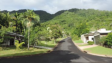
Harrison Close looking west, 2018
|
|||||||||||||||
| Population | 2,827 (2021 census) | ||||||||||||||
| • Density | 912/km2 (2,360/sq mi) | ||||||||||||||
| Established | 1989 | ||||||||||||||
| Postcode(s) | 4870 | ||||||||||||||
| Area | 3.1 km2 (1.2 sq mi) | ||||||||||||||
| Time zone | AEST (UTC+10:00) | ||||||||||||||
| Location |
|
||||||||||||||
| LGA(s) | Cairns Region | ||||||||||||||
| State electorate(s) | Cairns | ||||||||||||||
| Federal Division(s) | Leichhardt | ||||||||||||||
|
|||||||||||||||
Kanimbla is a suburb of Cairns in Queensland, Australia. It's like a neighborhood within the bigger city of Cairns. In 2021, about 2,827 people lived there.
Contents
Where is Kanimbla?
Kanimbla is located about 6 kilometers (or 3.7 miles) west of the main city center of Cairns.
The suburb is situated near Moody's Creek. A major road, the Cairns Western Arterial Road, forms its northern border. Ramsey Drive is the main road that runs through Kanimbla. In the southwest, there are hills that reach over 500 meters (about 1,640 feet) high, near a place called Mooroobool Peak.
Kanimbla's History
Kanimbla is located on the traditional lands of the Yidiny people, who are Indigenous Australians.
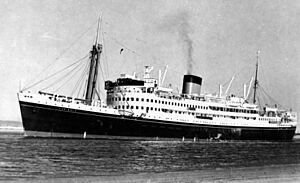
The suburb of Kanimbla was officially created on February 11, 1989. It was formed from parts of nearby suburbs like Manoora and Mooroobool. The name "Kanimbla" comes from the MV Kanimbla, which was a coastal passenger ship. This ship used to travel to Cairns before it became a military ship during World War II. Interestingly, Manoora and Mooroobool were also names of other coastal passenger ships.
In 2013, the Cairns Regional Council bought land in Kanimbla. They planned to build a special area called a detention basin. This basin helps to collect extra water during heavy rains. It stops flooding in other suburbs located further downstream.
People Living in Kanimbla
In 2016, Kanimbla had a population of 2,670 people. By 2021, the number of people living in Kanimbla had grown to 2,827.
Schools Near Kanimbla
There are no schools directly inside Kanimbla. However, there are several schools in the nearby areas.
- The closest government primary schools are Whitfield State School in Whitfield (to the north) and Cairns West State School in Manunda (to the east).
- The nearest government high school is Trinity Bay State High School, also in Manunda.
- You can also find a number of private schools in other nearby suburbs of Cairns.
Fun Places to Visit
Campbells Lookout is a great spot to visit in Kanimbla. It's located on Lake Morris Road (16°55′44″S 145°43′15″E / 16.9290°S 145.7209°E).
From Campbells Lookout, you can see amazing views. You can look out over the different suburbs of Cairns. You can also see all the way to the Cairns CBD (the city center) and Trinity Bay beyond. It's a popular place for people to enjoy the scenery.
 | Selma Burke |
 | Pauline Powell Burns |
 | Frederick J. Brown |
 | Robert Blackburn |


