Cairns City, Queensland facts for kids
Quick facts for kids Cairns CityCairns, Queensland |
|||||||||||||||
|---|---|---|---|---|---|---|---|---|---|---|---|---|---|---|---|

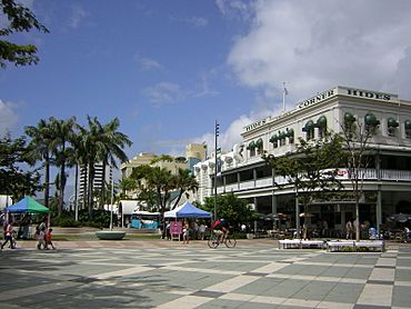
Cairns City, 2005
|
|||||||||||||||
| Population | 3,616 (2021 census) | ||||||||||||||
| • Density | 977/km2 (2,530/sq mi) | ||||||||||||||
| Postcode(s) | 4870 | ||||||||||||||
| Area | 3.7 km2 (1.4 sq mi) | ||||||||||||||
| Time zone | AEST (UTC+10:00) | ||||||||||||||
| Location |
|
||||||||||||||
| LGA(s) | Cairns Region | ||||||||||||||
| State electorate(s) | Cairns | ||||||||||||||
| Federal Division(s) | Leichhardt | ||||||||||||||
|
|||||||||||||||
Cairns City is a suburb right in the middle of Cairns, a city in Queensland, Australia. It's also known as the Cairns Central Business District (CBD), which means it's the main area for shops, offices, and businesses. In 2021, about 3,616 people lived here.
Contents
What is Cairns City Like?
Location and Surroundings
Cairns City is located right on the coast. It's bordered by Trinity Bay to the northeast and Trinity Inlet to the east. These are parts of the ocean that come into the land.
Train lines run along the southern and western edges of the suburb. The main Cairns railway station is here, where trains arrive and depart. There was also an old train station at Cairns Wharf, but it's not used anymore.
A Look Back in Time
Early History and Name
Cairns City is on the traditional land of the Yidiny people, who are Aboriginal people.
The name Cairns was chosen to honor William Cairns. He was the Governor of Queensland from 1875 to 1877. The suburb officially became "Cairns City" on September 1, 1973.
Schools and Churches
Cairns State School first opened its doors on August 19, 1878. Over the years, it changed a few times, splitting into separate schools for boys and girls, then merging back together. It finally closed in 1994.
St Monica's Catholic College is a school that was started in 1890 by the Sisters of Mercy.
The Cairns Baptist Church, built from timber with strong concrete supports, opened in 1936. It was designed to withstand cyclones. Today, a more modern Baptist church stands on the same spot.
Community Events
In 1916, a special event called the Cane Beetles March started near Cairns. This was during World War I, and it was a march to encourage men to join the Australian army. It began with just 4 men and grew to 29 recruits by the time it reached Cairns, 60 kilometers away!
Who Lives Here?
Population Changes
The number of people living in Cairns City has grown over the years.
- In 2011, there were 2,180 people.
- By 2016, the population increased to 2,737 people.
- In 2021, the population reached 3,616 people.
Diversity in Cairns City
In 2016, about 3.9% of the people living in Cairns City were Aboriginal and Torres Strait Islander people. Most residents (42.7%) were born in Australia, and the next largest group came from England (5.8%). English was the main language spoken at home for 54.8% of people.
Important Places and Buildings
Heritage-Listed Sites
Cairns City has many buildings and places that are considered important because of their history. These are called heritage-listed sites. Some examples include:
- The Dr EA Koch Memorial on Abbott Street
- The Barrier Reef Hotel
- The old Cairns Customs House
- The Cairns Court House
- The Cairns City Council Chambers
- The St Monica's War Memorial Cathedral
- The Cairns War Memorial on The Esplanade
- The Cairns Wharf Complex
Learning and Education
Schools in Cairns City
St Monica's College is a Catholic high school for girls, teaching students from Year 7 to Year 12. In 2018, it had 672 students.
There are no government schools directly in Cairns City. Students usually go to nearby schools like Parramatta State School for primary education or Cairns State High School for secondary education.
University Campus
The Central Queensland University also has a campus in Cairns City, offering higher education courses.
Everyday Services
Police and Post Office
You can find the Cairns Police Station and the Cairns Post Office in the suburb. There's even a smaller police office inside the Cairns Central Shopping Centre.
Health Care
Cairns City has many health care places, including:
- Cairns Day Surgery
- Cairns Private Hospital
- Calvary Hospital
- Various medical centers like Wuchopperen Surgery
Fun Things to Do
Shopping and Entertainment
Cairns Central is the biggest shopping mall in the Far North Queensland area. It has 180 stores, including big department stores, supermarkets, and cinemas. The Cairns railway station is also part of this complex.
The Pier is a great place for shopping and dining right by the waterfront.
Museums and Libraries
The City Library is located in the former Cairns City Council Chambers. It opened in 1979 and offers public Wi-Fi and many services.
The Cairns Museum is located in the old Cairns School of Arts building. Here, you can learn all about the history of Cairns.
Attractions and Activities
The Cairns Aquarium is a popular attraction. It focuses on the amazing plants and animals found in the Great Barrier Reef and the Daintree Rainforest, both of which are famous World Heritage areas.
The Reef Hotel Casino offers accommodation, restaurants, and entertainment. On top of it, you'll find the Cairns Wildlife Dome, where you can see different animals and even try ropes courses!
The Cairns Marlin Marina is a large marina where many boats are docked. It's a hub for tourist boats and fishing charters, including those for game fishing.
Parks and Recreation
Cairns City has several parks where you can relax and enjoy the outdoors, such as Grafton Street Park and Munro Martin Park.
 | James Van Der Zee |
 | Alma Thomas |
 | Ellis Wilson |
 | Margaret Taylor-Burroughs |


