Stratford, Queensland facts for kids
Quick facts for kids StratfordCairns, Queensland |
|||||||||||||||
|---|---|---|---|---|---|---|---|---|---|---|---|---|---|---|---|

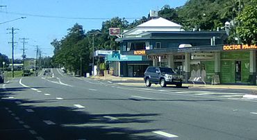
View of Stratford town along Kamerunga Road and Stratford Parade
|
|||||||||||||||
| Population | 1,198 (2021 census) | ||||||||||||||
| • Density | 631/km2 (1,630/sq mi) | ||||||||||||||
| Established | 1877 | ||||||||||||||
| Postcode(s) | 4870 | ||||||||||||||
| Elevation | 5 m (16 ft) | ||||||||||||||
| Area | 1.9 km2 (0.7 sq mi) | ||||||||||||||
| Time zone | AEST (UTC+10:00) | ||||||||||||||
| Location |
|
||||||||||||||
| LGA(s) | Cairns Region | ||||||||||||||
| County | Nares | ||||||||||||||
| State electorate(s) | Barron River | ||||||||||||||
| Federal Division(s) | Leichhardt | ||||||||||||||
|
|||||||||||||||
|
|||||||||||||||
Stratford is a suburb located in the Cairns Region of Queensland, Australia. It is part of the larger city of Cairns. In 2021, about 1,198 people lived in Stratford.
Contents
Where is Stratford Located?
Stratford is about 6.8 kilometers (4.2 miles) northwest of the main business area of Cairns. The Barron River forms its northern border. To the east, you'll find the Captain Cook Highway.
Land and Nature in Stratford
The northern part of Stratford sits on the lower slopes of Mount Whitfield and Lumley Hill. These areas are between 10 and 40 meters above sea level and are mostly used for homes. The southern part of Stratford has thick, undeveloped bushland. This land rises higher, reaching about 160 meters (525 feet) above sea level.
How Many People Live in Stratford?
The number of people living in Stratford has changed over the years.
- In 2006, there were 1,178 residents.
- By 2011, the population was 1,109 people.
- In 2016, it grew slightly to 1,138 people.
- The most recent count in 2021 showed 1,198 people living in Stratford.
What Historical Places Can You Find in Stratford?
Stratford has some places that are listed for their historical importance. These are called heritage-listed sites.
- One important site is the former Explosives Magazine and Detonator Store on Magazine Street. This building was once used to store explosives.
In 2009, for the Q150 celebrations (marking 150 years of Queensland), the Stratford and Freshwater Community Association created a special heritage trail. This trail has 29 signs in Stratford and 22 signs in the nearby suburb of Freshwater, Queensland, telling the history of these areas.
Community Facilities in Stratford
Stratford offers several useful places for its residents.
Stratford Library
The Cairns Regional Council runs a public library at 11 Kamerunga Road. It's a great place to find books and information.
Stratford Community Hall
Right next to the library, at 15 Kamerunga Road, is the Stratford Community Hall. This hall can hold up to 50 people and is managed by the Stratford & Freshwater Community Association. It's used for community events and meetings.
St Augustine's Catholic Church
St Augustine's Catholic Church is located at 23 Kamerunga Road. It is part of the Northern Beaches Parish within the Roman Catholic Diocese of Cairns.
Barron River Boat Ramp
There is a boat ramp and a floating walkway on Greenbank West Road. This spot is on the south bank of the Barron River, close to the William Walter Mason Bridge. It's managed by the Cairns Regional Council and is a good place for people who want to use the river.
 | James Van Der Zee |
 | Alma Thomas |
 | Ellis Wilson |
 | Margaret Taylor-Burroughs |


