
Caravonica, Queensland facts for kids
Quick facts for kids CaravonicaCairns, Queensland |
|||||||||||||||
|---|---|---|---|---|---|---|---|---|---|---|---|---|---|---|---|

Caravonica and the suburbs to the south east
|
|||||||||||||||

Caravonica
Location in Queensland
|
|||||||||||||||
| Population | 2,183 (2021 census) | ||||||||||||||
| • Density | 475/km2 (1,230/sq mi) | ||||||||||||||
| Postcode(s) | 4878 | ||||||||||||||
| Area | 4.6 km2 (1.8 sq mi) | ||||||||||||||
| Time zone | AEST (UTC+10:00) | ||||||||||||||
| Location |
|
||||||||||||||
| LGA(s) | Cairns Region | ||||||||||||||
| State electorate(s) | Barron River | ||||||||||||||
| Federal Division(s) | Leichhardt | ||||||||||||||
|
|||||||||||||||
Caravonica is a suburb located in Cairns, Queensland, Australia. It's part of the wider Cairns Region. In 2021, about 2,183 people lived here.
Caravonica is about 11 kilometers (7 miles) northwest of the main Cairns city centre.
Contents
Exploring Caravonica's Geography
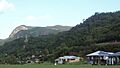
Caravonica is nestled in the foothills of the beautiful Queensland tropical rain forests. The main village area is about 1.2 kilometers (0.75 miles) long.
The suburb stretches north to the Tjapukai Aboriginal Cultural Park. The southern station for the Skyrail Rainforest Cableway is also found here. This station is known as the Caravonica Terminal. The southern edge of Caravonica meets Kamerunga along the Barron River.
Discover Lake Placid
Within Caravonica, you'll find a neighborhood called Lake Placid. It used to be known as Barron Waters. This area gets its name from a natural pond in the Barron River. This pond was formed by a natural rock barrier. Lake Placid is also the main entrance to the amazing Barron Gorge National Park.
A road called Lake Placid Road leads to Kamerunga Conservation Park. It also goes to Kamerunga Crossing, which is a place where you can cross the Barron River. There's an old bridge here that cars no longer use.
Maps of Caravonica
-
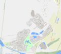
Map of Caravonica
-
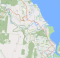
Map of Caravonica in the Cairns Region


A Look Back at Caravonica's History

Caravonica is located on the traditional lands of the Djabugay (Tjapukai) Aboriginal people. The Yirrganydji people are also important custodians of this land.
The name "Caravonica" comes from a town in Italy. It was named in the 1880s after the hometown of a person named David Thomatis.
Caravonica was once part of the Shire of Mulgrave. Later, it became part of the City of Cairns local government area.

Kamerunga State School first opened its doors on May 28, 1913. Sadly, a cyclone destroyed it in February 1927. However, the school reopened on April 6, 1927, in a new spot. It was then renamed Caravonica State School. The decision to move the school had actually been made before the cyclone hit.
The area known as Lake Placid was originally called Barron Waters. It was renamed in 1969.
Who Lives in Caravonica?
In 2016, Caravonica had a population of 1,989 people. By 2021, the number of people living in Caravonica had grown to 2,183.
Learning in Caravonica

Caravonica State School is a government primary school for students from Prep to Year 6. It's located at Lot 3 Kamerunga Road. In 2018, the school had 537 students and many dedicated teachers and staff. It also offers a special education program.
There are no government high schools directly in Caravonica. Students usually attend Smithfield State High School in nearby Smithfield. Another option is Redlynch State College in Redlynch.
Community Groups
The Smithfield branch of the Queensland Country Women's Association (CWA) meets in Caravonica. Their hall is on Kamerunga Road, between Caravonica State School and the Australian Armour and Artillery Museum.
Images for kids
-
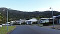
Aarona Street – a typical street
-
View cross suburbia from Kwana Street
-

Kwana Street
-
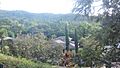
Suburban landscape with Red Peak


