Fitzroy Island (Queensland) facts for kids
|
Native name:
Koba or Gabar or Goong-Gan-Jee
|
|
|---|---|

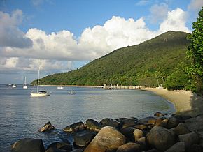
Welcome Bay, Fitzroy Island
|
|
| Geography | |
| Location | Coral Sea |
| Coordinates | 16°56′S 146°00′E / 16.933°S 146.000°E |
| Area | 11.6 km2 (4.5 sq mi) |
| Highest elevation | 240 m (790 ft) |
| Administration | |
|
Australia
|
|
| State | Queensland |
| LGA | Cairns Region |
| Demographics | |
| Population | 85 (2021) |
| Fitzroy Island Cairns, Queensland |
|
|---|---|
| Population | 85 (2021 census) |
| • Density | 7.33/km2 (19.0/sq mi) |
| Postcode(s) | 4871 |
| Area | 11.6 km2 (4.5 sq mi) |
| Time zone | AEST (UTC+10:00) |
| LGA(s) | Cairns Region |
| State electorate(s) | Mulgrave |
| Federal Division(s) | Kennedy |
Fitzroy Island is a beautiful island located off the coast of Queensland, Australia. It's about 29 kilometers (18 miles) southeast of Cairns. The island is also a small community within the Cairns Region. In 2021, about 85 people lived on Fitzroy Island. Its original names from the Aboriginal people were Koba, Gabar, or Goong-Gan-Jee.
Contents
Geography of Fitzroy Island
Fitzroy Island is a large tropical island. It has lush rainforests and its own coral reef system. This reef is part of the amazing Great Barrier Reef Marine Park. The island covers an area of 11.6 square kilometers (4.5 square miles). Its highest point reaches 240 meters (790 feet) above the sea.
Getting to Fitzroy Island
You can reach Fitzroy Island by a 45-minute ferry ride from Cairns. The island is mostly protected as part of the Fitzroy Island National Park. There are four walking tracks for visitors to explore different parts of the island.
Climate on Fitzroy Island
Fitzroy Island has a tropical monsoon climate. This means it has a long, hot, and very wet season during summer. The winter months are shorter, warm, and much drier.
| Climate data for Fitzroy Island Lighthouse (16º56'S, 146º00'E, 124 m AMSL) (1968-1991 normals and extremes) | |||||||||||||
|---|---|---|---|---|---|---|---|---|---|---|---|---|---|
| Month | Jan | Feb | Mar | Apr | May | Jun | Jul | Aug | Sep | Oct | Nov | Dec | Year |
| Record high °C (°F) | 36.1 (97.0) |
35.6 (96.1) |
35.9 (96.6) |
33.3 (91.9) |
30.0 (86.0) |
28.9 (84.0) |
30.0 (86.0) |
29.6 (85.3) |
31.6 (88.9) |
32.9 (91.2) |
34.0 (93.2) |
39.9 (103.8) |
39.9 (103.8) |
| Mean daily maximum °C (°F) | 30.6 (87.1) |
30.1 (86.2) |
29.4 (84.9) |
27.9 (82.2) |
25.9 (78.6) |
23.9 (75.0) |
23.5 (74.3) |
24.9 (76.8) |
26.8 (80.2) |
28.8 (83.8) |
30.1 (86.2) |
30.7 (87.3) |
27.7 (81.9) |
| Mean daily minimum °C (°F) | 24.5 (76.1) |
24.1 (75.4) |
23.8 (74.8) |
22.7 (72.9) |
21.3 (70.3) |
19.4 (66.9) |
19.0 (66.2) |
19.4 (66.9) |
20.7 (69.3) |
22.3 (72.1) |
23.6 (74.5) |
24.4 (75.9) |
22.1 (71.8) |
| Record low °C (°F) | 20.0 (68.0) |
19.4 (66.9) |
20.0 (68.0) |
18.5 (65.3) |
13.9 (57.0) |
13.9 (57.0) |
13.6 (56.5) |
13.3 (55.9) |
15.0 (59.0) |
19.0 (66.2) |
19.7 (67.5) |
20.6 (69.1) |
13.3 (55.9) |
| Average precipitation mm (inches) | 480.1 (18.90) |
477.5 (18.80) |
486.7 (19.16) |
303.1 (11.93) |
225.5 (8.88) |
124.1 (4.89) |
74.2 (2.92) |
72.1 (2.84) |
44.8 (1.76) |
46.6 (1.83) |
114.7 (4.52) |
214.4 (8.44) |
2,664.4 (104.90) |
| Average precipitation days (≥ 1.0 mm) | 14.9 | 16.9 | 18.4 | 17.3 | 15.6 | 10.2 | 9.5 | 7.6 | 6.3 | 5.8 | 7.6 | 11.2 | 141.3 |
| Average afternoon relative humidity (%) | 75 | 78 | 78 | 79 | 80 | 77 | 77 | 73 | 69 | 68 | 69 | 72 | 75 |
| Average dew point °C (°F) | 24.2 (75.6) |
24.4 (75.9) |
23.8 (74.8) |
22.4 (72.3) |
20.7 (69.3) |
18.1 (64.6) |
17.9 (64.2) |
18.2 (64.8) |
19.1 (66.4) |
20.7 (69.3) |
22.1 (71.8) |
23.5 (74.3) |
21.3 (70.3) |
| Source: Bureau of Meteorology | |||||||||||||
History of Fitzroy Island
Fitzroy Island became separate from the mainland about 8,000 years ago. This happened at the end of the last ice age. Aboriginal people often visited the island for hunting and fun. The Yidiny people called the island "Gabar", which means "lower arm". This name came from how part of the island was underwater.
Naming and Early Uses
In 1770, Lieutenant James Cook named the island after Augustus Henry FitzRoy. For a long time, the island was used as a quarantine station. This was a place where people arriving, especially those heading to the Queensland goldfields, would stay to make sure they were healthy. Later, it became a mission school. During World War II, it served as a coast watch station.
Lighthouse and Modern Development
Fitzroy Island was also an important base for a lighthouse. The old lighthouse building on the main island is still a popular sight. Today, an automatic lighthouse on nearby Little Fitzroy Island guides ships. In the past, there was a giant clam farm at Welcome Bay. Now, the island has a tourist resort and a center for day visitors.
Demographics of Fitzroy Island
The population of Fitzroy Island has grown over the years.
- In 2016, there were 44 people living on the island.
- By 2021, the population had increased to 85 people.
Attractions on Fitzroy Island
Fitzroy Island offers many fun things to do for visitors.
- The Resort: The island has a resort with 99 rooms. It includes a restaurant, a swimming pool, and a swim-up bar. There's also a dive and activity center. The resort was first opened in 1981 and was updated in 2010.
- Foxy's Bar and Cafe: This large bar and cafe has a fun Pacific Islands theme. It's located right on the beach, close to the resort.
- Camping: For those who love the outdoors, the resort also manages a camping area on the island.
 | William Lucy |
 | Charles Hayes |
 | Cleveland Robinson |


