Atherton, Queensland facts for kids
Quick facts for kids AthertonQueensland |
|||||||||||||||
|---|---|---|---|---|---|---|---|---|---|---|---|---|---|---|---|

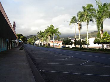
The main street of Atherton
|
|||||||||||||||
| Population | 7,724 (2021 census) | ||||||||||||||
| • Density | 82.08/km2 (212.6/sq mi) | ||||||||||||||
| Postcode(s) | 4883 | ||||||||||||||
| Elevation | 752 m (2,467 ft) | ||||||||||||||
| Area | 94.1 km2 (36.3 sq mi) | ||||||||||||||
| Time zone | AEST (UTC+10:00) | ||||||||||||||
| Location |
|
||||||||||||||
| LGA(s) | Tablelands Region | ||||||||||||||
| State electorate(s) | Hill | ||||||||||||||
| Federal Division(s) | Kennedy | ||||||||||||||
|
|||||||||||||||
|
|||||||||||||||
Atherton is a country town in Queensland, Australia. It is located in the Tablelands Region. In 2021, about 7,724 people lived in Atherton.
Contents
Where is Atherton?
Atherton is found in Far North Queensland. It sits on a high area called the Atherton Tableland.
Many roads connect Atherton to other towns.
- The Gillies Highway goes to Yungaburra.
- The Kennedy Highway heads north to Mareeba. It also goes south to Ravenshoe and Mount Garnet.
- The Malanda–Atherton Road leads to Malanda.
- The Atherton–Herberton Road connects to Herberton.
A Look Back in Time
The land around Atherton has a long history. It is the traditional home of the Yidinji Aboriginal people. Their language region covers parts of the Cairns Region and Tablelands Region. This includes areas like Cairns, Gordonvale, and the southern Atherton Tableland.
How Atherton Got Its Name
The town was named after John Atherton. He was an early settler who arrived in Mareeba in 1875. Before being called Atherton, the area was known as Priors Pocket or Priors Creek. Falconer West Hutton, a surveyor, officially named it Atherton on May 11, 1885.
Early Days and Growth
- The first school, Atherton Provisional School, opened on March 2, 1891. It closed for a short time but reopened as Atherton State School in 1906.
- Atherton Pioneer Cemetery opened in 1897. A new cemetery, Rockley Road Cemetery, opened in 1927.
- The Atherton Post Office started operating by 1903.
- Another school, Cairns Road State School, opened in 1921 but closed in 1963.
- St Joseph's School opened its doors on January 29, 1923.
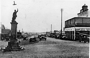
The Atherton War Memorial remembers local people who died in World War I. It was officially opened on May 1, 1924. This memorial is special because it shows a soldier in an active pose. It was moved from the middle of the street to a park after the 1950s.
During World War II, the Atherton Courthouse was used as a hospital for officers. It even had air raid bunkers underground.
- The Atherton Parish of the Roman Catholic Church was created in 1949.
- Atherton State High School opened on January 27, 1959.
- The Atherton Public Library first opened in 1978.
- Jubilee Christian College began in 1984.
People of Atherton
Atherton has grown steadily over the years.
- In 2011, about 7,287 people lived here.
- By 2016, the population was 7,331.
- In 2021, the number of residents reached 7,724.
What Happens Here?
Atherton is a busy and successful community. It has a pleasant climate, which is cooler and less humid than the coast. This makes it a popular place for people to retire or move to from the city. Housing prices are also lower than in nearby Cairns.
Farming and Food
The land around Atherton is very fertile. Farmers grow many different crops, including:
- Coffee
- Sugar cane
- Peanuts
- Mangoes
- Corn
- Potatoes
- Avocados
- Blueberries, blackberries, and strawberries
- Macadamia nuts
- Dairy and beef cattle are also raised in the area.
Fun and Festivals
- Each year in late August, Atherton celebrates the Maize Festival. This festival includes a parade with decorated floats. There's also a Maize Queen pageant, rides for kids, and activities like tug-of-war.
- The annual Atherton Agricultural Show takes place in July. It's held at the Atherton Showgrounds, which includes the historic Merriland Hall.
- For sports fans, the Atherton Roosters have teams in the Cairns District Rugby League.
Learning and Growing
Atherton has several schools for students of all ages.
- Atherton State School is a primary school for students from Prep to Year 6. It is located at 28 Armstrong Street. In 2017, it had 473 students.
- St Joseph's School is a Catholic primary school for Prep to Year 6. You can find it at the corner of Jack & Alice Streets. In 2017, it had 252 students.
- Jubilee Christian College is a private school for students from Prep to Year 12. It is located at 52 Grau Street. In 2017, it had 908 students.
- Atherton State High School is a government high school for Years 7 to 12. It is on Maunds Road. In 2017, it had 780 students. This school also has a special online program called the School of Astronomy and Astrophysics.
Atherton also has a technical and further education (TAFE) campus. This is called the Tropical North Institute of TAFE. There are also two day care centres in town.
Community Places
- The Tablelands Regional Council runs the Atherton Library. It is at 16 Robert Street and was updated in 2012.
- The Atherton branch of the Queensland Country Women's Association meets at the CWA Hall. This hall is on the corner of Jack Street and Arnott Lane.
- St Joseph's Catholic Church is at 28 Mabel Street.
- Atherton Uniting Church is on the corner of Jack Street and Victoria Street.
Getting Around
Trans North provides bus services connecting Atherton to other towns. These include Tolga, Walkamin, Mareeba, Kuranda, and Cairns. You can also connect to Ravenshoe and Herberton. Atherton also has a taxi service.
Special Places
Atherton has several places that are listed for their historical importance.
- Herberton Road: Chinatown
- Herberton Road: Atherton Chinese Temple
- Kennedy Highway: Atherton War Memorial
- Corner of Kennedy Highway and Rockley Road: Atherton War Cemetery
- 42 Mable Street: Atherton State School Head Teacher's Residence
- 53 Main Street: Barron Valley Hotel
- Mazlin Street: Merriland Hall
- 6 Silo Street: Atherton Performing Arts Theatre (a World War II building)
Famous Faces
Some well-known people have connections to Atherton:
- Peter Beattie: A former Premier of Queensland.
- Ron Grainer: A composer famous for the Doctor Who theme music.
- Rod Jensen: A former professional rugby league player.
- Dallas Johnson: Another former professional rugby league player.
- Elizabeth O'Conner: An author.
- Ren Pedersen: An advocate for children's brain cancer research.
- Alexander Prokhorov: A physicist and Nobel Prize winner.
- Roberto Venturato: A football coach and former player.
Atherton's Weather
Atherton has a humid subtropical climate. This is different from the tropical climate of the surrounding areas. This is because Atherton is high up on the Atherton Plateau, about 752 meters above sea level.
The temperature in Atherton has ranged from a high of 36.7 degrees Celsius to a low of -0.6 degrees Celsius. The town gets about 1,379.8 mm of rain each year. It is one of the most northern places in Australia to sometimes experience frost.
| Climate data for Atherton (1992-2009) | |||||||||||||
|---|---|---|---|---|---|---|---|---|---|---|---|---|---|
| Month | Jan | Feb | Mar | Apr | May | Jun | Jul | Aug | Sep | Oct | Nov | Dec | Year |
| Record high °C (°F) | 36.0 (96.8) |
33.5 (92.3) |
32.6 (90.7) |
31.1 (88.0) |
29.0 (84.2) |
30.0 (86.0) |
30.3 (86.5) |
30.0 (86.0) |
34.9 (94.8) |
36.7 (98.1) |
36.6 (97.9) |
36.4 (97.5) |
36.7 (98.1) |
| Mean daily maximum °C (°F) | 28.4 (83.1) |
27.8 (82.0) |
26.4 (79.5) |
25.0 (77.0) |
23.4 (74.1) |
21.5 (70.7) |
21.4 (70.5) |
22.4 (72.3) |
25.6 (78.1) |
27.5 (81.5) |
28.7 (83.7) |
29.0 (84.2) |
25.6 (78.1) |
| Mean daily minimum °C (°F) | 18.8 (65.8) |
19.3 (66.7) |
18.3 (64.9) |
16.7 (62.1) |
14.0 (57.2) |
12.8 (55.0) |
10.2 (50.4) |
11.1 (52.0) |
12.6 (54.7) |
15.2 (59.4) |
16.7 (62.1) |
18.3 (64.9) |
15.3 (59.5) |
| Record low °C (°F) | 8.2 (46.8) |
13.8 (56.8) |
11.0 (51.8) |
8.4 (47.1) |
3.0 (37.4) |
−0.6 (30.9) |
−0.5 (31.1) |
1.7 (35.1) |
3.0 (37.4) |
6.0 (42.8) |
7.9 (46.2) |
8.0 (46.4) |
−0.6 (30.9) |
| Average rainfall mm (inches) | 235.5 (9.27) |
347.7 (13.69) |
224.7 (8.85) |
118.7 (4.67) |
59.6 (2.35) |
42.0 (1.65) |
40.0 (1.57) |
34.5 (1.36) |
19.2 (0.76) |
35.2 (1.39) |
72.0 (2.83) |
150.7 (5.93) |
1,379.8 (54.32) |
| Average rainy days (≥ 0.2mm) | 19.8 | 20.6 | 17.4 | 20.8 | 16.6 | 16.1 | 12.5 | 11.9 | 8.3 | 9.4 | 11.0 | 15.5 | 179.9 |
| Source: Bureau of Meteorology | |||||||||||||
 | Shirley Ann Jackson |
 | Garett Morgan |
 | J. Ernest Wilkins Jr. |
 | Elijah McCoy |


