Kairi, Queensland facts for kids
Quick facts for kids KairiQueensland |
|||||||||||||||
|---|---|---|---|---|---|---|---|---|---|---|---|---|---|---|---|

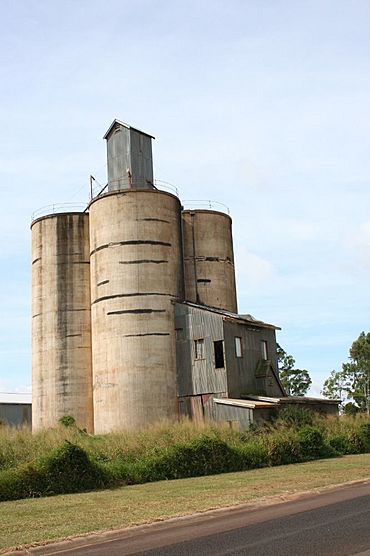
Kairi Maize Silos, 2007
|
|||||||||||||||
| Population | 490 (2021 census) | ||||||||||||||
| • Density | 13.32/km2 (34.5/sq mi) | ||||||||||||||
| Postcode(s) | 4872 | ||||||||||||||
| Elevation | 697 m (2,287 ft) | ||||||||||||||
| Area | 36.8 km2 (14.2 sq mi) | ||||||||||||||
| Time zone | AEST (UTC+10:00) | ||||||||||||||
| Location | |||||||||||||||
| LGA(s) | Tablelands Region | ||||||||||||||
| State electorate(s) | Hill | ||||||||||||||
| Federal Division(s) | Kennedy | ||||||||||||||
|
|||||||||||||||
|
|||||||||||||||
Kairi (say it like "care-eye") is a small town and area in the Tablelands Region of Queensland, Australia. It's a rural place, meaning it's mostly countryside. In 2021 census, about 490 people lived in Kairi.
Contents
Kairi's Location
Kairi is found on the Atherton Tableland, which is a high area in Far North Queensland. It's quite close to Lake Tinaroo, a large lake. The town of Tinaroo is only 4 kilometres (2.5 mi) north of Kairi.
Kairi is about 1,698 kilometres (1,055 mi) by road northwest of Brisbane, the capital city of Queensland. It sits about 719 metres (2,359 ft) above sea level, which means it's pretty high up! There used to be a railway station in Kairi, but it's now closed.
Kairi's Weather
Kairi has a special type of climate called a dry-winter humid subtropical climate. This means it has two main seasons:
- A very warm and wet season from November to April.
- A pleasant dry season from May to October.
Because Kairi is high up, its temperatures are a bit cooler than places closer to the coast. In the hottest month, December, the average high is around 28.8 °C (83.8 °F). In the coolest month, July, the average high is about 21.1 °C (70.0 °F). Kairi gets about 1,300.5 mm (51.20 in) of rain each year.
Kairi's Past
Local Aboriginal Language
The land around Kairi is the traditional home of the Yidinji people. Their language, also called Yidinj or Idindji, is an Aboriginal language. It was spoken in areas like Cairns, Gordonvale, and the southern part of the Atherton Tableland, including Kairi.
Kairi State School Opens
The first school in Kairi, called Kairi State School, opened its doors on 24 July 1911. It has been teaching local children for over 100 years!
The State Farm Story
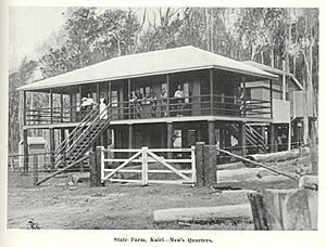
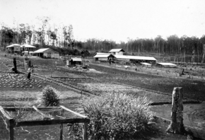
In May 1911, the Queensland Government decided to set up a special farm in Kairi called the State Farm. They started by clearing about 50 acres of land. The farm's main goal was to focus on raising dairy cows and pigs.
By March 1912, the farm was also growing many crops like maize (corn), cow peas, rhodes grass, pumpkins, and cucumbers. The State Farm closed in 1929, though the pig farm kept going for a few more years. After that, private businesses ran the farm.
Changes to the Farm
In 1932, there was an idea to turn the Kairi State Farm into an agricultural college. This college would teach students about farming in tropical northern Queensland. People really liked this idea, but it didn't happen for a long time.
During World War II in 1944, the Australian Army took over the farm. They used it to grow vegetables and produce eggs to feed the soldiers. After the war, in 1946, the farm became a research station. Its job was to find ways to improve the soil on the Atherton Tableland, which was becoming less productive.
Even though people still wanted an agricultural college, the government announced in 1954 that it wouldn't be built. Finally, in March 1962, the State Farm officially became a Research Station for the Queensland Department of Agriculture.
The Agri-Science Hub
In October 2011, most of the old State Farm land (209 hectares) was sold by the Queensland Government. They kept a smaller part, about 26 hectares. The money from the sale helped create the Agri-Science Hub in Mareeba. This hub is a modern center for farming research, development, education, and training. James Cook University works with the hub to study things like tropical farming, raising fish (aquaculture), and keeping Australia safe from plant and animal diseases (biosecurity).
Kairi's People
The number of people living in Kairi has changed over the years:
- In 2006 census, there were 193 people.
- In 2011 census, the population grew to 460 people.
- In 2016 census, there were 442 people.
- In 2021 census, the population was 490 people.
Special Places
Kairi has some important historical sites that are heritage-listed. One of these is the Kairi Maize Silos, which are tall structures used to store corn.
Learning in Kairi
Kairi State School is a primary school for students from Prep (the first year of school) to Year 6. It's located on McGeehan Street (17°12′54″S 145°32′45″E / 17.2151°S 145.5459°E). In 2018, the school had 86 students.
There isn't a high school in Kairi itself. Students who want to go to secondary school usually attend Atherton State High School in the nearby town of Atherton.
 | Frances Mary Albrier |
 | Whitney Young |
 | Muhammad Ali |


