Tinaroo Dam facts for kids
Quick facts for kids Tinaroo Dam |
|
|---|---|
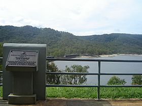
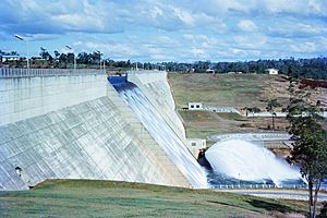
A photo of the Tinaroo Dam wall
|
|
|
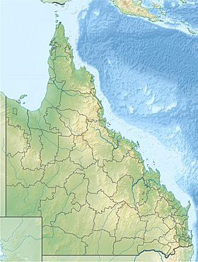
Location of the Tinaroo Dam in Queensland
|
|
| Official name | Tinaroo Falls Dam |
| Country | Australia |
| Location | Far North Queensland |
| Coordinates | 17°09′49″S 145°32′47″E / 17.16361°S 145.54639°E |
| Purpose | Irrigation; water supply; hydroelectricity; recreation |
| Status | Operational |
| Construction began | 1953 |
| Opening date | 1958 |
| Construction cost | A$12.6 million |
| Owner(s) | SunWater |
| Dam and spillways | |
| Type of dam | Gravity dam |
| Impounds | Barron River |
| Height | 42 metres (138 ft) |
| Length | 533 metres (1,749 ft) |
| Width (base) | 35.4 metres (116 ft) |
| Dam volume | 223 thousand cubic metres (7.9×10⁶ cu ft) |
| Spillways | 1 |
| Spillway type | Ungated, central ogee |
| Spillway capacity | 1,160 cubic metres per second (41,000 cu ft/s) |
| Reservoir | |
| Creates | Lake Tinaroo |
| Total capacity | 438,919 ML (15,500.3×106 cu ft) |
| Catchment area | 545 km2 (210 sq mi) |
| Surface area | 3,500 ha (8,600 acres) |
| Maximum water depth | 41.8 m (137 ft) |
| Normal elevation | 670.4 m (2,199 ft) AHD |
| Power station | |
| Name | Tinaroo Hydro Power Station |
| Coordinates | 17°09′49″S 145°32′50″E / 17.16361°S 145.54722°E |
| Operator(s) | SunWater |
| Commission date | May 2004 |
| Type | Conventional |
| Turbines | Francis turbine |
| Installed capacity | 1.6 megawatts (2,100 hp) |
| Annual generation | 5,579 megawatt-hours (20,080 GJ) |
The Tinaroo Dam, also known as the Tinaroo Falls Dam, is a big dam in Far North Queensland, Australia. It was built across the Barron River on the Atherton Tableland. This dam helps with irrigation, provides water, creates electricity, and is a popular spot for fun activities. It was finished between 1953 and 1958. When the dam was built, it formed a large lake called Lake Tinaroo.
Contents
About Tinaroo Dam
The Tinaroo Dam is located near other beautiful lakes like Lake Barrine and Lake Eacham. The dam wall is made of 223,000 cubic metres of concrete. It stands 42 metres high and stretches 533 metres long.
When Lake Tinaroo is full, the water can be up to 41.8 metres deep. The lake holds a huge amount of water, about 438,919 megalitres. This is roughly 75% of the size of Sydney Harbour! The lake's surface covers 3,500 hectares, and the area that collects water for the dam is 545 square kilometres.
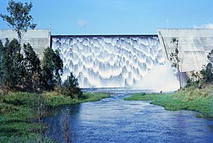
The dam has a special part called a spillway. This allows extra water to flow out safely. It can release 1,160 cubic metres of water per second. There are also two gates that release water for irrigation. Another valve lets water flow into the Barron River.
When the dam was finished in 1958, unexpected early rains arrived. This meant some large construction equipment was left behind. To this day, some of these machines are still underwater at the base of the dam wall.
In 2011, the dam's owner, SunWater, made some important upgrades. They strengthened the main dam wall with steel cables. They also added a concrete slab at the bottom. The height of a smaller dam nearby was also raised by 30 centimetres. Filters were added to help prevent damage during floods.
History of Tinaroo Dam
James Venture Mulligan was the first European explorer to visit the tablelands in 1875. The area is now known as the Atherton Tablelands. It was named after John Atherton, who settled there. A popular story says that John Atherton found tin and shouted "Tin, Harroo!!" to his friend. This might be how the name "Tinaroo" came about.
In 1952, the Queensland Government approved the building of the Tinaroo Dam. They also approved the Mareeba-Dimbulah Irrigation Scheme. Construction on the dam began in 1953 and was completed in 1958. It cost about A$12.666 million.
When the dam filled with water in 1959, the old town of Kulara went underwater. All the people living there moved to nearby towns like Yungaburra. The school building in Kulara was on higher ground. It did not flood and became a private home. Before Kulara, the area of Danbulla also went underwater. Many residents from Danbulla had to move as their farms were taken over for the dam.
How Tinaroo Dam Helps
Water for Farms
The Mareeba-Dimbulah Irrigation Area is very large, covering almost 1,200 square kilometres. It spreads across the valleys of the Barron, Walsh, and Mitchell Rivers. About 415 square kilometres of farmland get water from Lake Tinaroo. The lake provides 205,000 megalitres of water each year. Farmers get this water through a big network of 176 kilometres of channels. Some areas use gravity to get water, while others use pumps. Farms not connected to the channels can draw water from streams. These streams are refilled by the Barron River, which gets its water from the lake.
Making Electricity
The Tinaroo Hydro Power Station started working in 2004. It can generate 1.6 megawatts of power. This helps reduce 8,450 tonnes of carbon dioxide from going into the air each year. The dam also controls the water flow for the Barron Gorge Power Station. This power station is located 81 kilometres downstream from the dam.
Town Water Supply
Several towns get their water from Tinaroo Dam. These include Tinaroo, Walkamin, Mareeba, Kuranda, and Yungaburra. They get water through the Barron River. The towns of Mutchilba and Dimbulah also get water from the irrigation channel system.
Fun at Lake Tinaroo
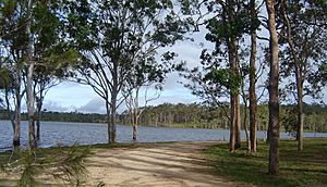
Lake Tinaroo is a very popular place for tourists and locals. Over 500,000 people visit each year. It is located on the beautiful Atherton Tableland. The Tinaroo Range and the Danbulla State Forest surround the lake.
Water Sports
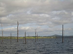
Lake Tinaroo has over 200 kilometres of shoreline. It has many calm bays that are protected from the wind. This makes it a great place for sailing, water skiing, houseboating, and swimming. During dry times, the water level can drop. This makes some of the trees that were flooded when the dam was built become hazards for boats. Sunwater, the dam owners, do not cut down these trees. Cutting them at water level can create hidden stumps or floating obstacles. It is against the law to cut trees in the lake without permission.
Hiking Trails
The lake is surrounded by national park, rainforest, and Australian "bush". There are many hiking paths around the lake and its mountains. You can find easy walks from parking lots to the water. There are also longer treks that can take a week to complete.
Fishing Fun
Many types of fish and other water animals live in Lake Tinaroo. Barramundi can grow very large here because they have no natural enemies. Each year, young barramundi are added to the lake from the Walkamin Research Station. This is because they cannot breed in the lake without access to salt water.
Other fish in Lake Tinaroo include:
- Eel-tailed catfish
- Sooty grunter
- Sleepy cod
- Mouth almighty
- Archer fish
- Spangled perch
- Long tom
Many types of crayfish are also found, like the red-claw and yabby. You need a Stocked Impoundment Permit to fish in the dam.
Unfortunately, Tilapia were illegally put into Lake Tinaroo. They are now a harmful pest species. If you catch a Tilapia, you must destroy and bury it. It is against the law to keep, sell, or buy Tilapia. It is also illegal to release them into Queensland waterways or use them as bait.
Tinaroo Dam Facts
| Key Dam Structure | |
|---|---|
| Height | 42 metres (138 ft) |
| Length | 533 metres (1,749 ft) |
| Thickness at base | 35.4 metres (116 ft) |
| Spillway type | Ungated, central ogee spillway |
| Spillway capacity | 1,160 cubic metres per second (41,000 cu ft/s) |
| Dam wall volume | 223 thousand cubic metres (7.9×10⁶ cu ft) |
| Irrigation outlets | 2 x 500 millimetres (20 in) radial gates |
| Barron River outlet | 1 x 500 millimetres (20 in) core valve |
| Key Lake Statistics | |
|---|---|
| Total capacity (when full) | 438,919 megalitres (15,500.3×106 cu ft) |
| Surface area | 3,500 hectares (8,600 acres) |
| Length | 15 kilometres (9.3 mi) |
| Deepest point | 41.8 metres (137 ft) |
| Full supply level | 670 metres (2,200 ft) AHD |
| Catchment area | 545 square kilometres (210 sq mi) |
| Average yearly rainfall | 1,300 millimetres (51 in) |
| Annual water for irrigation | 205,000 megalitres (7,200×106 cu ft) |
 | Selma Burke |
 | Pauline Powell Burns |
 | Frederick J. Brown |
 | Robert Blackburn |


