
Mitchell River (Queensland) facts for kids
Quick facts for kids Mitchell |
|
|---|---|

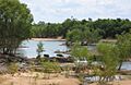
View inland, up the Mitchell River, at small waterfalls in between Dunbar and Koolatah Stations...
|
|

Location of Mitchell River mouth in Queensland
|
|
| Country | Australia |
| State | Queensland |
| Region | Far North Queensland |
| Physical characteristics | |
| Main source | Atherton Tableland, Great Dividing Range west of Kuranda 376 m (1,234 ft) 16°46′42″S 145°18′11″E / 16.77833°S 145.30306°E |
| River mouth | Gulf of Carpentaria north of Kowanyama 0 m (0 ft) 15°11′47″S 141°35′04″E / 15.19639°S 141.58444°E |
| Length | 750 km (470 mi) |
| Basin features | |
| Basin size | 41,435 km2 (15,998 sq mi) |
| Tributaries |
|
| National parks | Hann Tableland National Park; Mitchell-Alice Rivers National Park; Chillagoe-Mungana Caves National Park; Bulleringa National Park; Forty Mile Scrub National Park |
The Mitchell River is a long river in Far North Queensland, Australia. It starts on the Atherton Tableland, which is about 50 kilometers (31 miles) northwest of Cairns.
The river then flows for about 750 kilometers (466 miles) northwest across the Cape York Peninsula. It goes from Mareeba all the way to the Gulf of Carpentaria.
The area of land that drains into the Mitchell River is called its watershed. This watershed covers a huge area of 71,757 square kilometers (27,705 square miles). The Mitchell River has the largest amount of water flowing out of any river in Queensland each year. However, it doesn't flow all the time and can be dry for parts of the year. Lake Mitchell is the main place where water is stored on the river.
The river was named by Ludwig Leichhardt on June 16, 1845. He named it after Sir Thomas Mitchell during his trip from Moreton Bay to Port Essington. Some people think it might have been named the Vereenighde River in 1623 by a Dutch explorer named Jan Carstensz.
Contents
The River's Journey and Surroundings

The Mitchell River and its smaller rivers (tributaries) have been flowing west for a very long time. They cut through the rocky highlands of the Great Dividing Range. As they flow, they carry away dirt and rocks. This material then settles in the wide, flat areas and wetlands of the Gulf Savannah country.
The river's waters change a lot each year. During the monsoon season, heavy rains cause the river to swell. It collects water from the tropical rainforests in the eastern highlands. It also gathers water from the wet sclerophyll forests in the central uplands.
The river also gets water from different woodlands and savannah areas in the western plains. When the river floods with fresh water each year, it covers the tidal plains, wetlands, estuaries, and mangroves near the coast.
From where it starts to where it meets the sea, the Mitchell River is joined by 34 other rivers and streams. Some of these are the McLeod River, Hodgkinson River, St George River, Dry River, Little Mitchell River, Walsh River, Lynd River, Palmer River, and Alice River.
Nature and Wildlife Along the River

The Mitchell River system is very large. It might be one of Australia's most diverse places for nature and wildlife. It has many different types of wet and dry tropical habitats.
Scientists have described the nature of the Mitchell River area like this: The plants in the Mitchell River area range from the World Heritage Wet Tropic rainforest in the eastern highlands to the open savannah on the western plains. The large mangrove and lagoon systems at the river's mouth are known worldwide. There are also places with water all year round, like springs and water holes, in the upper parts of the river.
This river system is rich in nature, but it hasn't been studied a lot. However, we know it is home to at least 18 types of animals that are rare, endangered, or vulnerable. These include the golden-shouldered parrot, the Gouldian finch, and the northern bettong. The area where the river meets the sea is part of the Gulf Plains Important Bird Area. This means it's a very important place for birds.
Towns Near the River
Several towns are located in the area that drains into the Mitchell River. The main towns are Kowanyama, Chillagoe, Dimbulah, Mount Carbine, and Mount Molloy.
Other smaller towns in the Mitchell River area include Mutchilba and Almaden.
History of the Area
The Kunjen language is spoken in Western Cape York. The Kunjen language area includes land within the Kowanyama Community Council and Cook Shire Council.
The Yir Yiront language is another Aboriginal language. Its traditional area is in Western Cape York. This includes parts of the Aboriginal Shire of Kowanyama and Shire of Cook. It covers the areas around the Coleman River and the Mitchell River. Today, after Aboriginal people were moved from their traditional lands, the language is also spoken in Pormpuraaw and Kowanyama.
Images for kids
-
View inland, up the Mitchell River, at small waterfalls in between Dunbar and Koolatah Stations...
-
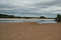
Mitchell River at Koolatah-Dunbar Crossing
-
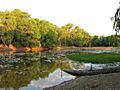
'Rich variety of aquatic habitats' - Magnificent Lagoon immediately next to Kowanyama township
See also
 In Spanish: Río Mitchell (Queensland) para niños
