
Mount Carbine, Queensland facts for kids
Quick facts for kids Mount CarbineQueensland |
|||||||||||||||
|---|---|---|---|---|---|---|---|---|---|---|---|---|---|---|---|

View from the service station on the eastern side of the Mulligan Highway across to the Mount Carbine hotel on the western side.
|
|||||||||||||||

Mount Carbine
Location in Queensland
|
|||||||||||||||
| Population | 94 (2021 census) | ||||||||||||||
| • Density | 0.0943/km2 (0.244/sq mi) | ||||||||||||||
| Postcode(s) | 4871 | ||||||||||||||
| Area | 997.2 km2 (385.0 sq mi) | ||||||||||||||
| Time zone | AEST (UTC+10:00) | ||||||||||||||
| Location |
|
||||||||||||||
| LGA(s) | Shire of Mareeba | ||||||||||||||
| State electorate(s) | Cook | ||||||||||||||
| Federal Division(s) | Leichhardt | ||||||||||||||
|
|||||||||||||||
Mount Carbine is a small rural town and area in Queensland, Australia. It is located in the Shire of Mareeba. In 2021, about 94 people lived in Mount Carbine.
Contents
Exploring Mount Carbine's Landscape
Mount Carbine is a place with lots of natural beauty. It is bordered on the east by the tall Great Dividing Range mountains.
Rivers and Waterways
The Mitchell River flows into Mount Carbine from the west. It forms part of the western and southern borders of the area. The Mcleod River also joins the Mitchell River here.
Protected Natural Areas
Much of Mount Carbine is covered by special protected areas. These places help keep nature safe.
- Mount Windsor National Park
- Mount Lewis National Park
- Mount Spurgeon National Park
A very large part of the south and west of Mount Carbine is called the Brooklyn Sanctuary. This is a nature reserve run by a group called the Australian Wildlife Conservancy. They work to protect animals and plants.
Most of the land in Mount Carbine is used for nature conservation. This means it's kept wild to protect the environment. There are also some farms where animals graze on the natural plants.
Roads and Mountains
The Mulligan Highway is an important road that goes through Mount Carbine. It connects the town to other places.
Mount Carbine is also home to several mountains:
- Carbine Hill (Pulchun) is 513 meters tall.
- Lighthouse Mountain (Cudgee Cudgee) is 812 meters tall.
- Little Alto is 465 meters tall.
- Mount Alto is 765 meters tall.
- Mount Armit is 794 meters tall.
- Mount Fraser is 1155 meters tall.
- Mount Misery is 1246 meters tall.
- Mount Spurgeon is 1322 meters tall.
- Ords Hill is 477 meters tall.
- Roots Mount is 1331 meters tall.
Mount Carbine's Past

The town of Mount Carbine got its name from a famous racehorse called Carbine. This horse won the big 1890 Melbourne Cup race. People who first settled here thought the town would become rich, so they named it after the famous winner.
Mining History
Mount Carbine was first settled around 1890 because people found a valuable mineral called wolfram (which is used to make tungsten). The town's early life depended completely on these mines.
The mining grew a lot from 1907, with a company led by John Moffat developing the mines. Most people living in Mount Carbine back then were connected to the wolfram mines. At its busiest, the town had about 300 residents, three hotels, a police station, a school, and other small businesses.
The mines stopped working in 1914 but opened again after World War I. They would open and close depending on how much wolfram was needed and its price. In the 1920s, demand for wolfram slowed down, making the mines less profitable.
There was another short period of mining in the late 1960s, which lasted for about 20 years. The mines closed again in the 1980s. Over time, the old mine sites have been cleaned up and restored.
Community Services in the Past
Mount Carbine had a Post Office that opened in 1907 and closed in 1970.
A school, Mount Carbine Provisional School, opened in 1908. It became Mount Carbine State School in 1909 but closed in 1927 because there weren't enough students. It reopened in 1939 but closed permanently in 1957.
The Brooklyn Sanctuary, a large nature reserve, was bought in 2004 to protect the wildlife.
Who Lives in Mount Carbine?
The number of people living in Mount Carbine has changed a little over the years:
- In 2006, there were 91 people.
- In 2016, there were 101 people.
- In 2021, there were 94 people.
Learning in Mount Carbine
There are no schools directly in Mount Carbine today. The closest primary school is Mount Molloy State School, which is in the nearby town of Mount Molloy. For high school, students usually go to Mossman State High School in Mossman.
Because Mount Carbine is a spread-out area, some students might live too far away to travel to these schools every day. In those cases, they might learn through distance education (learning from home) or go to a boarding school.
Places to Visit and Use
Mount Carbine has a few places for visitors and locals:
- A hotel/motel where people can stay.
- A roadhouse for fuel and food.
- A caravan park for campers.
The Mt Carbine Cemetery is a burial ground managed by the Mareeba Shire Council.
Images for kids
-
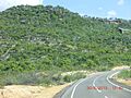
The Mulligan Highway passing through Mount Carbine in 2013.
-
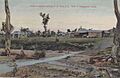
A view of Mount Carbine from the early 1900s.


