
Mitchell River (Victoria) facts for kids
Quick facts for kids Mitchell |
|
|---|---|

The Mitchell River in Bairnsdale
|
|

|
|
| Native name | Wangan, Wy-yung, Wahyang |
| Country | Australia |
| State | Victoria |
| Region | South East Corner (IBRA), South East Coastal Plain (IBRA), East Gippsland |
| Local government area | Shire of East Gippsland |
| Settlements | Lindenow, Bairnsdale |
| Physical characteristics | |
| Main source | Great Dividing Range |
| River mouth | Lake King 0 m (0 ft) 37°53′45″S 147°58′37″E / 37.89583°S 147.97694°E |
| Length | 121 km (75 mi) |
| Basin features | |
| River system | East Gippsland catchment |
| Tributaries |
|
| National park | Mitchell River NP |
The Mitchell River is a beautiful and important river in Victoria, Australia. It's called a perennial river because it flows all year round. This river is special because it's not controlled by dams, making it a great example of how rivers naturally flow and support life. Its waters come from the steep Victorian Alps mountains. The Mitchell River eventually joins Lake King, which is part of the large Gippsland Lakes system, before its waters reach the ocean in Bass Strait.
Contents
Journey of the Mitchell River
The Mitchell River starts where three smaller waterways meet: the Wentworth River, the Wonnangatta River, and Swamp Creek. This meeting point is near a place called Horseshoe Bend, just north of the Mitchell River National Park.
River's Path
From its start, the river flows mostly south. In its upper parts, it winds and turns a lot through the Mitchell River National Park. As it leaves the mountains, it flows onto the flat and fertile Gippsland Plain near Lindenow. The river then heads east towards Bairnsdale.
It finally empties into Jones Bay, which is part of Lake King. This happens through a unique feature called the silt jetties. These are long, narrow landforms that stretch about 8 kilometers into the lake. Inside Lake King, the Mitchell River is joined by the Nicholson River and the Tambo River. Later, it connects with the Latrobe River in Lake Victoria. Finally, the Mitchell River reaches its mouth in Bass Strait, south of Lakes Entrance. The river drops about 137 meters over its 121-kilometer journey. Many smaller streams, called tributaries, flow into the Mitchell River.
River Crossings
In Bairnsdale, the Princes Highway crosses the Mitchell River. There was also a railway line from Melbourne that crossed the river. Today, the train service stops before the river at Bairnsdale railway station. Buses now take people further east. The old railway bridge over the river might become part of a walking and cycling path called the East Gippsland Rail Trail. However, the bridge needs repairs to be safe.
Nature and History of the Mitchell River
The Mitchell River is very important for nature. Experts say it's a great example of the large natural systems that used to be common in southeastern Australia. Because of its special value, the Mitchell River was named a Heritage River in 1992.
Mitchell River National Park
The Mitchell River National Park protects the river as it flows between high cliffs and through several gorges. A famous place in the park is the Den of Nargun. This cave is mentioned in Aboriginal legends and is found on a small stream called Woolshed Creek, about 1 kilometer from the main river.
Aboriginal Significance
The Mitchell River was a very important place for the Gunai/Kurnai nation, especially the Brabuwooloong and Brayakuloong people of central Gippsland. They have lived along this river for thousands of years.
Early European Use
In the 1850s, the upper parts of the Wonnangatta and Dargo rivers were explored and mapped. From the 1860s, the town of Bairnsdale grew as a port. Boats could travel several kilometers up the Mitchell River from Bairnsdale. The Gippsland Lakes provided a way for steamboats to carry goods like livestock, timber, wool, and animal skins to markets in Melbourne.
Flooding of the River
The Mitchell River can sometimes flood, especially after heavy rains. These floods can cut off towns like Wy Yung and Lucknow from Bairnsdale. They can also cause a lot of damage to homes, farms, and roads. Big floods happened in April 1990 and June 2007. These floods are often caused by severe weather in the Gippsland region, which can also make other nearby rivers like the Thomson River and Avon River overflow.
Special Fish Species
The smaller streams that flow into the Mitchell River are home to many Australian grayling fish. This fish is considered a vulnerable species, meaning its population is at risk. Protecting the Mitchell River helps protect these important fish.
Mitchell River Silt Jetties
The Mitchell River silt jetties are a truly amazing natural feature. They are a classic example of a "digitate delta," which looks like fingers reaching out into the water. Geologists, who study the Earth, consider them one of the best examples of this landform in the world.
How Silt Jetties Form
When the Mitchell River meets Lake King, it slows down. This causes the river to drop the sand and mud it carries. Over thousands of years, this mud and sand have built up into long, narrow banks that stretch more than 8 kilometers into the lake. This process has been happening for about 10,000 years, ever since the last ice age ended and sea levels rose, filling the Gippsland Lakes. These silt jetties are thought to be the second largest in the world, after those found at the Mississippi River in the Gulf of Mexico.
Protecting the Jetties
The Mitchell River silt jetties are slowly being worn away by erosion. This erosion is partly caused by an increase in saltiness in the lakes. The channel that was created at Lakes Entrance in 1889 allowed more saltwater into the lakes. Other things that cause erosion include the loss of reeds, cows grazing on the river banks, people walking on the banks, and waves from boats.
The wetlands around the Gippsland Lakes, including those near the silt jetties, are very important for many waterbirds, including birds that migrate long distances. These wetlands are recognized internationally under the Ramsar Convention because of their importance.
Naming the Mitchell River
The Mitchell River has several names from Australian Aboriginal people. These names include Wangan in the Ganai language, Wy-yung in the Brabralung language, and Wahyang in another language group. All these names mean "spoon-billed duck."
The river's current name comes from Angus McMillan, an early European explorer and farmer. In 1839, he named the river after Thomas Mitchell, who was an explorer and the Surveyor General of New South Wales.
Images for kids
-
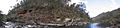
Panorama of the Mitchell River as it carves a valley through the Mitchell River National Park.
-
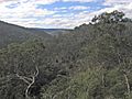
The river valley looking north from The Bluff Lookout high above the river in the Mitchell River National Park.
-
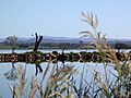
Mitchell River silt jetties, with the river in the foreground and Lake King in the distance.
-
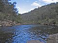
Downstream on the river near the junction with Woolshed Creek in the national park.


