
Nicholson River (Victoria) facts for kids
Quick facts for kids Nicholson |
|
|---|---|

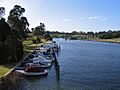
Looking south along the river from the East Gippsland Rail Trail trestle bridge at Nicholson.
|
|

|
|
| Native name | Yowen-burrun, Dart'yung, Geremoot, Ngarrak walang, |
| Country | Australia |
| State | Victoria |
| Region | South East Corner (IBRA), East Gippsland |
| Local government area | Shire of East Gippsland |
| Towns | Nicholson |
| Physical characteristics | |
| Main source | Angora Range, Great Dividing Range below Marthavale 440 m (1,440 ft) 37°26′43″S 147°31′24″E / 37.44528°S 147.52333°E |
| River mouth | Lake King to form confluence with the Mitchell River near Nicholson 0 m (0 ft) 37°50′53″S 147°43′54″E / 37.84806°S 147.73167°E |
| Length | 83 km (52 mi) |
| Basin features | |
| River system | Mitchell River catchment |
| Tributaries |
|
The Nicholson River is a river in the East Gippsland area of Victoria, Australia. It's part of the Mitchell River system. This river is called a perennial stream. This means it flows all year round.
Contents
Journey of the Nicholson River
The Nicholson River starts in the Angora Range. This area is part of the Victorian Alps and the Great Dividing Range. It begins near a small place called Marthavale. This is west of Ensay.
The river then flows mostly towards the southeast. It passes through the small town of Nicholson. Finally, it flows into Lake King. Lake King is one of the main lakes in the large Gippsland Lakes system.
Inside Lake King, the Nicholson River joins with the Mitchell River. The Mitchell River also connects with the Tambo River. The Mitchell River then flows into Bass Strait. This is southwest of Lakes Entrance.
The river drops about 440 meters (1,444 feet) from its start to its end. It travels a total distance of 83 kilometers (52 miles).
Nicholson River Dam
The Nicholson River has a dam called the Nicholson River Dam. This dam creates a water reservoir. A reservoir is like a large storage tank for water. This reservoir was used to supply drinking water to Lakes Entrance until 1995.
Crossing the River
In its lower parts, the river is crossed by several important routes. These include the Great Alpine Road and the Princes Highway. It is also crossed by the East Gippsland Rail Trail. This trail is a path for walking and cycling. It used to be part of the Orbost railway line.
How the River Got its Name
The Nicholson River has several old names from the Australian Aboriginal people.
Aboriginal Names
From the Brabralung language, part of the Gunaikurnai language, the river was called Yowen-burrun and Dart'yung. Both of these names mean "root of water plant". Another name was Geremoot, but its meaning isn't clear.
In the Tatungalung language, also part of the Gunaikurnai language, the river was called Ngarrak walang. This name means "back-stone".
European Naming
The river's current name comes from an early European explorer and farmer named Angus McMillan. In 1839, he named the river to honor Charles Nicholson. Charles Nicholson was an important person in the government at the time. He represented the Port Phillip District in the New South Wales Legislative Council. He later became the Colonial Secretary. This was a high-ranking government job.
Images for kids
-
Looking north to the rail trail trestle bridge across the river at Nicholson.

