
East Gippsland Rail Trail facts for kids
Quick facts for kids East Gippsland Rail Trail |
|
|---|---|

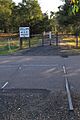
Trail signage and the trail near Bruthen
|
|
| Length | 96 kilometres (60 mi) |
| Location | East Gippsland, Victoria, Australia |
| Use | Hiking, biking, walking |
| Highest point | 129 metres (423 ft) (Colquhoun railway station) |
| Grade | Sealed, smooth gravel, stony gravel, and dirt |
| Difficulty | Easy to medium |
| Hazards | Uncontrolled crossings of major highways, isolated locations |
| Surface | Sealed, smooth gravel, stony gravel, and dirt |
The East Gippsland Rail Trail is a fantastic path in East Gippsland, Victoria, Australia. It's a special kind of path called a rail trail, which means it used to be a railway line! This trail is super popular for cycling, walking, and even horse riding.
The trail starts in Bairnsdale and goes all the way to Orbost. It follows the old Orbost railway line route. This railway line opened way back in 1916 to help move farm products and timber. It needed many big bridges because of the hilly land. But in 1987, the railway closed, and the tracks were removed in 1994. That's when it became the awesome trail we see today!
The East Gippsland Rail Trail is about 96 kilometers (60 miles) long. As you travel, you'll see all sorts of cool places, from forests to farmlands. Sometimes, you'll even get glimpses of the beautiful Gippsland Lakes. Some parts of the trail are smooth and easy for any bicycle. But other sections are a bit rougher, so a mountain bike or a strong hybrid bike is best for those parts. Remember, no motorized vehicles are allowed on the trail!
Contents
Exploring the Trail
The East Gippsland Rail Trail follows the path of the old railway line. It goes through or near small towns like Nicholson, Bruthen, Nowa Nowa, and Newmerella. There's also a short path that connects it to Orbost. It's a good idea to bring your own water and snacks. Most facilities like toilets and shops are only found in these towns. The trail has gentle slopes and curves, just like a railway line. The highest point on the trail is 129 meters (423 feet) at Colquhoun.
Along the way, you'll pass by old railway stations and sidings. These include Nicholson, Bumberrah, Mossiface, Bruthen, Colquhoun, Nowa Nowa, Tostaree, Waygara, and Orbost. You'll also cross or see many old railway bridges, including some really big trestle bridges. The trail starts near the Mitchell River. It crosses the Nicholson River, Tambo River, and Snowy River, plus many smaller creeks.

Bairnsdale to Nicholson (9km)
The East Gippsland Rail Trail doesn't officially start right at the Bairnsdale railway station. This is because the old railway bridge over the Mitchell River isn't safe for use. The trail begins on the south side of the Princes Highway. You'll find it opposite the Howitt Park sports grounds at McEacharn Street.
You can get to the trail from Bairnsdale by using the road or footpath on the Princes Highway bridge. At Howitt Park, on the north side of the highway, you'll find Toilets and plenty of car parking. To safely reach the trail, follow the path next to the Mitchell River. It goes under the road bridge and then up to the trail level.
From Bairnsdale, the trail heads east, following the old railway line. It runs roughly parallel to the Princes Highway. At first, you'll see some shops and factories. Then, the trail opens up into farmland, mostly with cows and horses. Finally, you'll reach the town of Nicholson.
You might catch distant views of the Gippsland Lakes in some spots. You'll also need to cross a few smaller roads. There's also an unmarked crossing of the Princes Highway. The trail surface is sealed with asphalt and is in good condition. This lasts until you reach the Nicholson River bridge in Nicholson, about 9 km from the start. This bridge used to be a railway bridge and is now covered with concrete. Just before the bridge, you'll see a sign for the old Nicholson railway station.
The trail passes just north of the Nicholson town. You can get into town by turning south at Nicholson-Sarsfield Road. Or, you can follow a small track along the west side of the Nicholson River. At the Nicholson boat ramp, on the west bank of the river, you'll find toilets, water, and barbecue facilities. {{gallery Image:At-Nicholson-Sarsfeild-Rd,-EG-Rail-Trail,-Nicholson,-VIC,-13.09.2008.jpg|Heading east along the rail trail at Nicholson, 9 km from Bairnsdale Image:Rail-Trail-Trestle-Bridge-close,-Nicholson,-VIC,-13.09.2008.jpg|The trail crosses the Nicholson River on a former railway bridge Image:Nicholson-River-and-road-bridge,-Nicholson,-VIC,-13.09.2008.jpg|Stunning views from the former railway bridge at Nicholson }}
Nicholson to Bruthen (22km)
After Nicholson, the rail trail crosses the Nicholson River on the old railway bridge. The bridge surface is now covered with concrete, offering great views. Beyond the bridge, the path turns into smooth gravel and heads away from the Princes Highway. You'll ride through rolling farmlands. The track surface gets a bit rougher as you go north. After 9 km, you'll reach the old Bumberrah railway station. Here, you'll find a rest stop with a shelter and an information board.
From Bumberrah, the trail continues for 8.5 km to Mossiface. You'll pass through old railway cuttings (where the ground was dug out) and fills (where earth was added). The surface in this part can be rough gravel, with occasional wombat holes! But you'll see lots of plants and animals, plus nice views of farms and hills. Mossiface is a tiny place with just a few houses. It was once the site of the Mossiface railway station. Here, you can see the Tambo River flats and old hop kilns.
After Mossiface, the trail goes north for about 2.5 km on a smooth gravel surface. It crosses the Great Alpine Road where a railway trestle bridge used to be. Just past this spot, about 2 km from Bruthen, the path splits. One path goes directly into Bruthen alongside the Great Alpine Road. The main rail trail continues to follow the old railway route, about 100 meters north of the road.
About half a kilometer before Bruthen, you can clearly see the remains of the old Bruthen railway station on the rail trail. Soon after, you can take a small detour from the trail to enter Bruthen. This is the biggest town along the way. You'll find food, drinks, toilets, and places to stay here. {{gallery Image:EG Rail Trail looking north at Bumberrah, 18.10.2008.jpg|Looking north from the former Bumberrah Station between Nicholson and Bruthen Image:EG Rail Trail looking south at Mossiface, 18.10.2008.jpg|Looking south at the site of the former Mossiface Railway Station Image:East-Gippsland-Rail-Trail-near-Bruthen-heading-East-2,-30.08.2008.jpg|The trail passes through and beside a former railway trestle bridge west of Bruthen }}
Bruthen to Nowa Nowa (27km)
From the Bruthen Station site, the rail trail continues under the Great Alpine Road through an old railway tunnel. It then goes around the southern edge of Bruthen, following the railway line. The trail crosses the Storer Bridge, which is a former railway bridge over the Tambo River. It's now covered with boards for the trail surface. Then, it passes behind the sports ground at the east end of town. You can take another detour into Bruthen from here.
After leaving Bruthen, the trail goes through some grazing land on a smooth gravel surface. Then, it enters an open eucalyptus forest called the Colquhoun State Forest. Here, the trail climbs steadily for several kilometers. The surface is stony gravel and can be a bit bumpy. There are also some sandy parts. At Seaton Track in the Colquhoun Forest, about 11 km from Bruthen, you can connect to the Gippsland Lakes Discovery Trail. This trail goes to Lakes Entrance, about 25 km south. This section of the trail is best for mountain bikes.
The East Gippsland Rail Trail continues east through the Colquhoun State Forest. The surface is generally good, and it goes downhill gradually. A few kilometers from the Discovery Trail turnoff is the site of the old Colquhoun railway station. This is the highest point on the trail, at 129 meters (423 feet). However, the forest is quickly growing over the site. Further along, about 4.5 km west of Nowa Nowa, you'll find the amazing Stony Creek Trestle Bridge. It was built in the early 1900s and is 276 meters (905 feet) long and 19 meters (62 feet) high! Because it's old, the bridge is fenced off. Trail users have to go down and up the steep slopes of the Stony Creek valley to get to the other side. There's a car park, toilet, and picnic area here.
The trail then continues to the small town of Nowa Nowa. Here, it leaves the old railway route and goes through the town. It runs onto an old part of the highway and down to the Lakes Entrance Road. Then, it turns sharply onto a concrete path through the town. The path goes under the highway and leaves town after crossing a bridge over Boggy Creek. Finally, it rejoins the original railway route on the east side of town. {{gallery Image:Junction of EG Rail Trail & Gipps Lakes Discovery Trail, 21.03.2009.jpg|Looking east at the junction with the Gippsland Lakes Discovery Trail in the Colquhoun Forest Image:Stony Creek Trestle Bridge Looking East near Nowa Nowa, Vic, 21.3.2009.jpg|The trail on the valley floor beside the Stony Creek Trestle Bridge near Nowa Nowa Image:Nowa Nowa Intersection Overview, Vic, 21.3.2009.jpg|The sealed trail passes through an underpass below the highway in Nowa Nowa }}
Nowa Nowa to Orbost (38km)
The section from Nowa Nowa to Newmerella is 36 km long. It was the last part of the trail to be built, opening in January 2006. Another 2 km of shared path takes the trail into Orbost.

The trail leaves Nowa Nowa after crossing the bridge over Boggy Creek. It soon rejoins the old railway line. The former Nowa Nowa railway station is just north of the trail. The station site is now used as a helicopter landing spot for emergencies. Not far from town, the track goes down to a creek crossing over Ironstone Creek. This bypasses the first and smallest of three wooden trestle bridges in this section. After this, the track steadily climbs for several kilometers. It has a rough, loose gravel surface. You'll see banksia and eucalypt trees, and some open farmland. Then, it goes downhill towards Wairewa Road, about 9 km from Nowa Nowa. The original railway line crossed this spot on a spectacular curved timber trestle bridge. This was the largest of the three bridges in this area. The bridge is still there, but the trail goes around it. You'll go down and across Wairewa Road, then climb back up to the railway level.

Beyond this point, the trail heads back towards the Princes Highway. It runs close to the highway for several kilometers. Near Johnsons Road, the trail passes the unmarked site of the old Tostaree railway station. It travels just north of the small area of Tostaree. Then, it drops down to another low creek crossing over Hospital Creek. This bypasses the third old railway trestle bridge. The track climbs again and soon moves away from the highway. It then goes through light forest and occasional farmland. The surface is quite wide but rough. You'll reach Partellis Crossing Road, which is about halfway through this section. Here, you'll find a picnic table, seats, and toilet facilities, but no water.
Continuing from Partellis Crossing, the trail goes for several kilometers through mixed forest and farmland. Then, it passes the former timber mill site of Waygara. Native plants are growing back here, but you can still see signs of the old mill. Look for a shed, an incinerator stack, and old mill houses. The former Waygara railway station was also here, but there's not much left of it. The trail then starts heading back towards the highway. It soon crosses Simpsons Creek and then Simpsons Creek Road. This area has more forests and lots of different plants and animals.

About 3 km further on is the first crossing of Joiners Road. From this point to Newmerella – about 5 km away – the trail runs very close to the Princes Highway. You'll start to see more signs of development, like timber mill operations and a pumping station for an underground gas pipeline. The trail crosses Prestons Road, which leads to the small town of Newmerella. The trail itself continues for another couple of kilometers. It makes a sharp turn through a cutting around a steep hillside. Then, it offers views over the Snowy River floodplain. Finally, it goes down to the end of the trail at Burn Road, north of the Princes Highway at Newmerella.

Across the road from the end of the rail trail is a shared path. This path was built in 2007/08 and leads into Orbost, about 2 km further on. The original Orbost terminus of the line was on the west bank of the Snowy River. The train never actually crossed the river into Orbost itself. The shared path travels near this station site, but there's not much left of it. However, there is an impressive low causeway over the river flats. It's made of timber and steel bridges and is called the Orbost Viaduct. This shows the original route of the railway. There are no plans to open this part as part of the rail trail.

Images for kids
-
Rail track is clearly visible as the trail crosses the Nicholson-Sarsfield Road

 Geographic data related to East Gippsland Rail Trail at OpenStreetMap
