
OpenStreetMap facts for kids

OpenStreetMap of Cambridge, England
|
|
|
Type of site
|
Collaborative mapping |
|---|---|
| Available in | Over 50 site translations and unlimited map languages |
| Owner | OpenStreetMap Community. Project support by OpenStreetMap Foundation. |
| Created by | Steve Coast |
| Alexa rank | ▲ 8,412 (July 2013[update]) |
| Commercial | No |
| Registration | Required for contributors |
| Users | 904,752 |
| Launched | 1 July 2004 |
OpenStreetMap (often called OSM) is a free map of the entire world. It's like a giant digital map that anyone can help build and improve. Think of it as the "Wikipedia of maps."
People from all over the world work together to create and update this map. They use special devices and tools to gather information about roads, buildings, parks, and more. This map data can be used by anyone for free, as long as they follow certain rules about sharing.
.jpg)
Contents
What is OpenStreetMap?
OpenStreetMap is a project that aims to create a free and open map of the whole planet. Unlike maps made by companies, OSM is built by a community of volunteers. This means the map is always growing and getting better.
How the Map is Made
People add information to OpenStreetMap in several ways:
- Using GPS devices: Volunteers walk or drive around with a GPS device. This device records their exact location. Later, they use this data to draw roads, paths, and other features on the map.
- Looking at aerial photos: They also use satellite and aerial images. These pictures help them see buildings, rivers, and land features from above.
- Local knowledge: Many people add details they know about their local area. This could be the name of a small shop, a public bench, or a new bike path.
All this information is put together to create a detailed digital map.
Why is it "Open"?
The "Open" in OpenStreetMap means two important things:
- Open Data: The map data itself is free to use. Developers can download it to create their own apps or services. Researchers can use it for studies.
- Open Contribution: Anyone can join the community and help improve the map. You don't need special permission to start adding details.
This open approach makes OSM a powerful tool for many different uses.
How OpenStreetMap is Used
OpenStreetMap data is used in many different ways around the world. Because it's free and open, it can be adapted for many purposes.
Many popular apps and websites use OpenStreetMap data for their maps. This includes:
- Navigation apps: Some apps that help you find your way around use OSM data.
- Fitness trackers: Devices that track your runs or bike rides might use OSM to show your route.
- Public transport apps: Apps that show bus or train routes often rely on OSM.
Disaster Relief and Humanitarian Aid
OpenStreetMap plays a big role in helping during emergencies.
- Crisis mapping: When a disaster like an earthquake or flood happens, volunteers quickly map affected areas. They add details like damaged roads, shelters, and safe routes.
- Aid organizations: Groups like the Red Cross use these maps to plan how to deliver help. They can see where people need food, water, or medical supplies.
- Community support: Local people can add information about what's happening on the ground. This helps everyone respond faster.
For example, after the 2013 Haiyan typhoon in the Philippines, many volunteers helped update the map. This made it easier for aid workers to reach people in need.
Research and Planning
Scientists and city planners also use OpenStreetMap.
- Environmental studies: Researchers can use the map to study forests, rivers, and how land is used.
- City planning: Governments and planners use OSM to understand traffic patterns or plan new parks.
- Community projects: Local groups might use the map to highlight historical sites or walking trails in their area.
Joining the OpenStreetMap Community
If you're interested in maps and technology, you can become part of the OpenStreetMap community!
- Editing: You can start by adding small details to your local area. This could be a new park bench, a missing building, or a corrected street name.
- Learning: There are many online guides and tutorials to help you learn how to edit the map.
- Connecting: You can join online forums or local groups to meet other mappers.
Every small contribution helps make the world's free map even better.
Images for kids
-
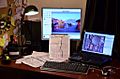
Editing with JOSM after a ground survey
-
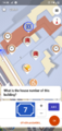
StreetComplete asking user a question. User filled in the answer. After tapping "OK" this answer will be added to an OpenStreetMap database.
-
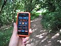
Surveying routes with a Satellite navigation device
-
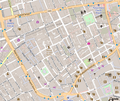
OpenStreetMap of Soho, central London, shown in "standard" OpenStreetMap layer
-
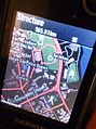
OpenStreetMap Philippines GPS map, an end-product of over a thousand crisis mappers that contributed almost 5 million map updates during the 2013 Haiyan humanitarian activation.
-

The Forest Landscape Integrity Index, which incorporates a global planet dump of OSM.
-
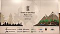
State of the Map Asia 2017 Conference Poster
-
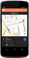
Moovit Navigate


See also
 In Spanish: OpenStreetMap para niños
