
Princes Highway facts for kids
Quick facts for kids Princes HighwayNew South Wales–South Australia |
|
|---|---|
 |
|
| General information | |
| Type | Highway |
| Length | 1,898 km (1,179 mi) |
| Gazetted | November 1913 (VIC, as Main Road) July 1925 (VIC, as State Highway) August 1928 (NSW, as Main Road 1) |
| Route number(s) | See Route allocation |
| Former route number |
See Former routes |
| Major junctions | |
| East end | Ultimo, Sydney |
|
|
| West end | Glen Osmond, Adelaide |
| Location(s) | |
| Major settlements | Wollongong, Nowra, Ulladulla, Batemans Bay, Eden, Orbost, Sale, Traralgon, Melbourne, Geelong, Warrnambool, Mount Gambier, Kingston SE, Tailem Bend, Murray Bridge, Crafers |
| Highway system | |
| Highways in Australia National Highway • Freeways in Australia Highways in New South Wales Highways in Victoria Highways in South Australia |
|
The Princes Highway is a very important road in Australia. It stretches a long way, connecting three states: New South Wales, Victoria, and South Australia. This highway links major cities like Sydney, Melbourne, and Adelaide.
The Princes Highway is about 1,898 kilometers long. It mostly follows the beautiful Australian coastline. This makes it a longer but often more scenic journey compared to other direct highways between the big cities. For example, it's a much longer drive from Sydney to Melbourne on the Princes Highway than on the Hume Highway. Many people choose the Princes Highway for a more relaxed and enjoyable trip.
Contents
Exploring the Princes Highway
The Princes Highway takes you on an amazing journey across Australia. Let's explore its path through each state.
New South Wales: The Journey Begins


The Princes Highway starts in Sydney, in a suburb called Chippendale. It begins as City Road and then becomes King Street. After King Street, it continues as the Princes Highway.
This part of the highway has many lanes, making it easy to drive. A special part of the highway is the twin Tom Uglys Bridge across the Georges River. One bridge opened in 1929, and the other in 1987.
The highway goes through Sydney's southern suburbs like Kogarah and Sutherland.
Towards Wollongong
South of a town called Waterfall, there's a faster road called the Princes Motorway. Most cars use this motorway to get to Wollongong. The Princes Highway then enters Wollongong through a place called the Bulli Pass.
Through Wollongong, the Princes Motorway is the main road for long-distance travel. The Princes Highway here is more for local traffic.
South Coast Adventure
After Wollongong, the Princes Highway becomes a dual carriageway, which means it has two lanes going in each direction. It passes through towns like Gerringong and Foxground. It also goes around the town of Berry.
Further south, the highway mostly has one lane in each direction. It winds along the beautiful NSW South Coast. You'll pass through charming towns such as Ulladulla, Batemans Bay, and Moruya.
The highway also goes through Narooma and Eden. It then crosses the border into Victoria. This is about 550 kilometers from Sydney.
Over the years, many parts of the highway in New South Wales have been improved. This includes adding more lanes and building bypasses around towns to make travel safer and faster.
Victoria: A Long and Winding Path

In Victoria, the Princes Highway has a very long and interesting route. When you drive through Melbourne, the highway uses different local road names. For example, parts are called Dandenong Road or Geelong Road.
Most of the busy traffic in Victoria uses the M1 Freeway route. This includes the Monash Freeway, CityLink, and West Gate Freeway. These roads are the fastest way to travel through Melbourne.
The Princes Highway in Victoria is about 955 kilometers long. From east to west, it goes through towns like Orbost, Bairnsdale, and Sale in the Gippsland region.
Through Melbourne and Geelong
The highway then passes through the Latrobe Valley. It goes around towns like Morwell and Pakenham before reaching Dandenong and the suburbs of Melbourne. Much of this section is a freeway.
Through Melbourne, the main route (National Route 1) is not actually on the Princes Highway. Instead, it follows the Monash Freeway and other freeways that go around the city center. This helps avoid traffic jams. These freeways have smart systems to manage traffic flow, like electronic signs and traffic lights on ramps.
Heading towards Geelong, the West Gate Freeway becomes the Princes Freeway. This freeway is very busy, often having four or three lanes in each direction. In Geelong, the highway becomes a three-lane road with traffic lights.
The Geelong Ring Road was completed in 2009. This ring road helps traffic go around Geelong without hitting any traffic lights. The Princes Highway in Geelong starts in Corio and goes through the city's suburbs.
Towards South Australia
After Geelong, the highway heads west. It continues as a dual carriageway to Winchelsea. West of Winchelsea, the road is being improved. It passes through Colac before reaching Warrnambool. This part of the highway goes inland, avoiding the slower but beautiful Great Ocean Road.
From Warrnambool, the Princes Highway goes through Portland. Then, it crosses the border into South Australia. At this point, you are about 1,530 kilometers from Sydney.
South Australia: The Final Stretch
In Mount Gambier, the highway turns north. It passes by the Coorong National Park, which is a beautiful coastal area. After Kingston SE, it turns inland to avoid the lakes near the River Murray.
Near Tailem Bend, the Princes Highway joins the Dukes Highway. This is a major road between Melbourne and Adelaide. The highway then turns northwest and becomes the South Eastern Freeway.
It crosses the Murray River and goes around Murray Bridge. The freeway continues to Glen Osmond, which is on the edge of Adelaide.
From Glen Osmond, the Princes Highway continues as Glen Osmond Road. It ends just south of the Adelaide city centre.
History of the Princes Highway
The Princes Highway has a rich history. The section between West Helensburgh and Bulli Tops was first used in 1843. It was the original coastal route connecting Sydney and Wollongong.
The highway got its name, Prince's Highway, in 1920. This was in honor of the planned visit by the Prince of Wales. He later became King Edward VIII. Even though the Prince didn't travel the whole road, he allowed it to be named after him.
Opening ceremonies for the highway were held in both New South Wales and Victoria in 1920. The first part in Victoria opened in Warragul on August 10. The road from Sydney opened in Bulli on October 19.
Road Management and Changes
Over the years, different government groups have managed the highway. In Victoria, the Country Roads Board (now VicRoads) took charge of major roads starting in 1912. The Princes Highway was officially declared a State Highway in Victoria in 1925.
In New South Wales, the Main Roads Board (now Transport for NSW) declared the Princes Highway as Main Road No. 1 in 1928. It became State Highway 1 in 1929. Before 1920, this road was simply known as the Coast Road.
In South Australia, roads were renamed in 1922 to form the Princes Highway route. Over time, parts of the highway have been replaced by newer, faster roads like the South Eastern Freeway. For example, the section between Kingston SE and Millicent was replaced by a more direct inland route.
In 2011, a section of the highway in South Australia was renamed to Port Wakefield Highway and Augusta Highway. This was done to help standardize road names.
Major Upgrades and Bypasses
The Princes Highway has seen many improvements over the years to make it safer and more efficient. Here are some important projects:
- 1940: A new section was built near Laverton in Victoria, including a bridge over the railway.
- 1961: The Maltby By-pass Road, Victoria's first "freeway," opened near Werribee.
- 1959–1963: The Princes Motorway in New South Wales opened in stages, becoming the main route for many drivers.
- 1979: The Swanport Bridge was completed in South Australia, helping the South Eastern Freeway bypass Murray Bridge.
- 1981: A bypass around Drouin in Victoria opened, adding two lanes in each direction.
- 1983: A bypass around Berwick in Victoria opened, making travel smoother.
- 1997: A section from Yarragon to Trafalgar in Victoria was duplicated, completing a dual carriageway from Melbourne to Traralgon.
- 2000: The Heysen Tunnels opened in South Australia, extending the South Eastern Freeway closer to Adelaide.
- 2005: The Kiama bypass opened in New South Wales, improving traffic flow.
- 2007: The Pakenham bypass opened in Victoria, helping drivers avoid the town center.
- 2008–2009: The Geelong Ring Road was completed in Victoria, allowing traffic to bypass Geelong.
- 2019–2021: The Albion Park Rail Bypass in New South Wales opened, connecting important sections of the highway.
These projects have made the Princes Highway a modern and important road for travel and trade across Australia.
Route Numbers on the Highway
The Princes Highway was given the number National Route 1 in 1955. This number showed it was a very important road connecting states. Later, in the 1970s, parts of it became a National Highway, meaning the federal government helped pay for its upkeep.
Today, most of the Princes Highway is known as A1 in Victoria, South Australia, and New South Wales. However, because of all the bypasses and new roads built over time, some older sections of the highway have different route numbers or no number at all. For example, the faster freeways that run alongside the original highway often have an 'M' number, like M1. This can make the route seem a bit complicated!
Images for kids
-
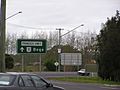
Princes Highway at Moruya.
-
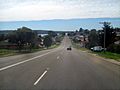
Princes Highway at Eden.
-
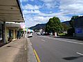
Princes Highway at Woonona
-
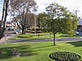
Princes Highway is picturesque in some towns, such as Gippsland’s Bairnsdale, where the median strip has been made a garden.

See also
 In Spanish: Carretera Princes para niños
