
Kings Highway (Australia) facts for kids
Quick facts for kids Kings HighwayAustralian Capital Territory–New South Wales |
|
|---|---|
 |
|
|
|
| General information | |
| Type | Highway |
| Length | 139 km (86 mi) |
| Gazetted | August 1928 (NSW) |
| Route number(s) |
|
| Former route number |
Entire route |
| Major junctions | |
| West end | Symonston, Australian Capital Territory |
|
|
| East end | Batemans Bay, New South Wales |
| Location(s) | |
| Major settlements | Bungendore, Braidwood, Nelligen |
| Highway system | |
| Highways in Australia National Highway • Freeways in Australia Road infrastructure in Canberra Highways in New South Wales |
|
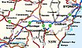
The Kings Highway is an important road in Australia. It connects Canberra, the nation's capital, to Batemans Bay on the beautiful South Coast of New South Wales. This highway is known as Route B52. It helps people from Canberra easily reach the beaches and coastal towns.
Contents
What is the Kings Highway?
The Kings Highway is an "interstate highway." This means it crosses between two different areas: the Australian Capital Territory (ACT) and New South Wales (NSW). It's a busy road, especially on weekends and during summer holidays. Many people use it to get to the coast for fun and relaxation.
Where Does the Highway Go?
The Kings Highway starts in Symonston in the ACT. It heads east along Canberra Avenue. Soon, it crosses into New South Wales near Queanbeyan. It goes through Queanbeyan and then Carwoola. For a short bit, it crosses back into the ACT's Kowen area. Then, it returns to NSW. The highway travels southeast through towns like Bungendore, Braidwood, and Nelligen. Finally, it reaches Batemans Bay.
The highway links the Monaro Highway in Canberra to the Princes Highway in Batemans Bay. As you travel, the scenery changes from flat farmlands where sheep graze to the Clyde Mountain area. This mountain pass takes you from the Southern Tablelands down to the coast.
Cool Spots Along the Way
There are a few interesting places to look out for on the Kings Highway:
- Pooh Bear's Corner: Near the top of the Clyde Mountain Pass, you can find a small rock cave. During World War II, this spot was used to store special materials. These materials could be used to block the road if needed, to protect the capital city.
- Soft Toy Trees: Between Queanbeyan and Bungendore, you might see many soft toys hanging in the eucalyptus trees. It's a unique and fun sight!
How Was the Highway Built?
The path for the road through the Clyde Mountain area was first explored in 1855 by Thomas Mitchell.
For many years, people crossed the Clyde River at Nelligen using a "punt service." A punt is like a flat boat that carries people and vehicles across a river. This service started in 1895. It connected Batemans Bay to Braidwood. The punt was used until 1964, when the Nelligen bridge was finished. A new Nelligen Bridge is being built and should open around late 2023.
In 1924, a law called the Main Roads Act was passed in New South Wales. This law helped the government fund important roads. On August 8, 1928, the Kings Highway was officially named "Main Road No. 51." Later, in 1929, it became "Trunk Road 51."
Even though it has been called Kings Highway for a long time, the road doesn't have an official "gazetted" name. This means it's not formally written down in government records as "Kings Highway." However, the local councils and Transport for NSW (the state transport agency) have agreed to put up signs calling it the Kings Highway.
In 1974, the Kings Highway was given the national route number 52. Later, in 2013, Australia changed its road numbering system. The Kings Highway then became known as Route B52, which it is today.
In 2006, a big military base called Headquarters Joint Operations Command (HQJOC) started being built in the ACT's Kowen district. This base opened in 2008. Because of the extra traffic to the base, parts of the Kings Highway near Queanbeyan have been improved.
Staying Safe on the Highway
The Kings Highway is a very busy road. In 2013, about 4,500 vehicles used it every day. This number goes up even more in the summer.
Unfortunately, the Kings Highway has a higher number of accidents compared to other roads in New South Wales. Over a 10-year period, there were about 877 accidents recorded. This means about one accident every four days. Some of these accidents were very serious. These accidents cost a lot of money for the local communities, sometimes millions of dollars each year.
Safety experts have looked at the highway. They found that the section over Clyde Mountain has the most accidents. Many accidents happen when a car leaves the road on a bend. Head-on crashes (when two cars hit each other front-to-front) also happen often. Accidents are most common on Sundays. Also, because of dry weather, there are more kangaroos near the road. This means more accidents happen between cars and kangaroos, especially at night. You can often see dead kangaroos on the side of the road.
Gallery
-
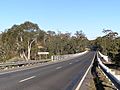
Warri Bridge, which crosses the Shoalhaven River near Braidwood.
-
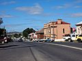
Kings Highway at Braidwood.
-
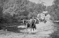
Horse teams carting goods from the ship at Nellingen to Braidwood, crossing Currajong Creek, about 1902.
-
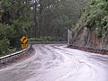
Climbing Clyde Mountain from the coast to Braidwood.
-
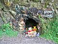
Pooh's Corner.
-
Kings Highway (formerly called Kings Way), National Route 52, links Canberrans to the coast.


