
Clyde River (New South Wales) facts for kids
Quick facts for kids Clyde River |
|
|---|---|

Clyde River flowing under the bridge at Batemans Bay
|
|
| Native name | Bhundoo |
| Other name(s) | "deep water "Yuin |
| Country | Australia |
| State | New South Wales |
| Region | South East Corner (IBRA), South Coast |
| Local government areas | Shoalhaven, Eurobodalla |
| City | Batemans Bay |
| Physical characteristics | |
| Main source | Budawang Mountains, Great Dividing Range near Kangaroo Hill, within Budawang National Park 597 m (1,959 ft) |
| River mouth | Tasman Sea, South Pacific Ocean Batemans Bay |
| Length | 102 km (63 mi) |
| Depth |
|
| Basin features | |
| Basin size | 1,723 km2 (665 sq mi) |
| Tributaries |
|
The Clyde River is a beautiful river in New South Wales, Australia. Its Aboriginal name is Bhundoo. This river flows into the Tasman Sea, which is part of the Pacific Ocean. It is known for having some of the cleanest water of any major river in eastern Australia.
Contents
Where the River Flows
The Clyde River starts high up in the Budawang Range. This area is part of the Great Dividing Range. It begins near a place called Kangaroo Hill, inside Budawang National Park.
- The river flows mostly south, following the coast.
- Nine smaller rivers and creeks join it along the way. These are called tributaries.
- Important tributaries include the Bimberamala River, Yadboro River, and Buckenbowra River.
- Finally, the river turns east and reaches the Tasman Sea at Batemans Bay.
- The river travels about 102 kilometres (63 mi) from its start to the sea. It drops about 601 metres (1,972 ft) in height along its journey.
The Estuary and Its Clean Water
The lower part of the Clyde River forms a large estuary. An estuary is where the river meets the sea. This part of the river is about 30 kilometres (19 mi) long. Small boats can travel on it up to a town called Nelligen.
- The estuary holds a lot of water, about 50,737 megalitres (1,791.8×106 cu ft).
- It covers an area of about 17.5 square kilometres (6.8 sq mi).
- The average depth of the estuary is about 3 metres (9.8 ft).
The Clyde River is special because it is one of the last major rivers in eastern Australia that has not been dammed. This means its natural flow is mostly untouched. A small dam called Porters Creek Dam is on a tiny creek that feeds into the Clyde, but it only supplies water to coastal towns.
The water quality in the Clyde River is excellent. The areas where the river starts are covered in thick forests and national parks. There are no big polluting factories or sewage pipes emptying into the river. This is why the Clyde River is famous for its very clean water.
River's Names and History
The original people of Australia, the Indigenous Australians, knew this river as the Bhundo.
The name "Clyde River" was given by Lieutenant Robert Johnston. He explored the river in 1821. He named it after the River Clyde in Glasgow, Scotland.
How to Cross the River
There are several places where you can cross the Clyde River:
- Yadboro Flats bridge: This bridge is downstream from where the Yadboro River joins the Clyde.
- Clyde Ridge Road bridge: Another bridge further down the river.
- Shallow Crossing: This is a concrete road that crosses the river. It's a low-level crossing, meaning it can sometimes be covered by water. It marks where the tide stops flowing up the river.
- Nelligen bridge: This bridge is part of the Kings Highway.
- Batemans Bay bridge: This bridge is on the Princes Highway at the river's mouth.
Images for kids
-
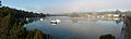
Early morning mist on the Clyde River at Nelligen, 2008.
-
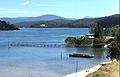
Clyde River, looking upstream from Batemans Bay towards the Budawang Range, 2009.
-
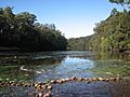
At Shallow Crossing, The River Road crosses the Clyde River at a concrete ford.
-
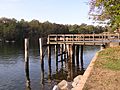
Wharf at Nelligen formerly used by the Illawarra Steam Navigation Company.


