
Budawang Range facts for kids
Quick facts for kids Budawang Range |
|
|---|---|
| Budawangs | |

The Seven Gods Monoliths
|
|
| Highest point | |
| Peak | Mount Budawang |
| Elevation | 1,129 m (3,704 ft) AHD |
| Dimensions | |
| Length | 53 km (33 mi) SSW / NNE |
| Geography | |

Location in New South Wales
|
|
| Country | Australia |
| State | New South Wales |
| Region | South Coast |
| Range coordinates | 35°17′S 150°10′E / 35.283°S 150.167°E |
| Parent range | Great Dividing Range |
The Budawang Range, often called The Budawangs, is a rugged and beautiful mountain range in New South Wales, Australia. It's part of the larger Great Dividing Range. You can find it within the Budawang National Park and the Morton National Park. The Budawangs are famous for their amazing landscapes and are a popular spot for bushwalking.
The highest point in this range is Mount Budawang, which stands at about 1,129 metres (3,704 feet) above sea level.
Contents
Exploring the Budawangs: Where is it?
The Budawangs start where the Clyde River and Endrick River begin. They stretch for about 53 kilometres (33 miles) towards Mount Budawang. This area is mostly made up of mountains and steep slopes, often around 334 metres (1,096 feet) high. These features form much of the western side of the Clyde River's watershed. A watershed is an area of land where all the water drains into a single river or lake.
The range also includes hills that go west from the north end of the Budawang Range. These hills are near Sassafras and stretch for about 21 kilometres (13 miles). They reach above where the Shoalhaven and Endrick rivers meet. The Pigeon House Range helps separate the waters flowing into the Endrick River from those flowing into the Shoalhaven River.
The Budawang Range is located about 190 kilometres (118 miles) south-southwest of Sydney. It also marks part of the border between the South Coast and the Southern Tablelands regions of New South Wales. Much of this land is protected as a wilderness area. This makes it a favourite place for bushwalkers because of its unique landscape.
Major Mountain Peaks in the Budawangs
The Budawangs include peaks from several smaller ranges. These are the Budawang Range itself, the Pigeon House Range, the Currockbilly Range, and the Wirritin Range. Here are some of the main peaks:
- Mount Budawang (1,129 m or 3,704 ft)
- Currockbilly Mountain (1,087 m or 3,566 ft)
- Wog Wog Mountain (893 m or 2,930 ft)
- Mount Cole (876 m or 2,874 ft)
- Sturgiss Mountain (858 m or 2,815 ft)
- Fosters Mountain (857 m or 2,812 ft)
- Barneys Hill (855 m or 2,805 ft)
- The Castle (831 m or 2,726 ft)
- Shrouded Gods Mountain (809 m or 2,654 ft)
- Donjon Mountain (786 m or 2,579 ft)
- Quiltys Mountain (775 m or 2,543 ft)
- Wirritin Mountain (674 m or 2,211 ft)
- Pigeon House Mountain / Didthul (665 m or 2,182 ft)
- Mount Bushwalker (640 m or 2,100 ft)
- Byangee Mountain (500 m or 1,640 ft)
- Mount Tarn
Other Amazing Places to See
Besides the mountain peaks, the Budawangs have other cool natural features. These include:
- Monolith Valley
- The Seven Gods Monoliths
- Clyde River Valley
- Hidden Valley
- Ettrema Gorge
History of the Land
Aboriginal History
The first people to live in The Budawangs were two Aboriginal groups. The Wandandians lived north of Pigeon House Mountain. The Walbanjas lived to the south of Pigeon House.
Archaeologists have found signs that Aboriginal people lived here about 11,000 years ago. Evidence from nearby coastal areas suggests people were there even 20,000 years ago. So, it's possible people lived in the Budawangs even earlier than we currently know.
Signs of their presence include campsites in rock shelters and open areas. They also left axe grinding grooves on rocks near creeks. There are also rare art sites and rock arrangements. One of the best examples is on Quilty's Mountain.
European Use of the Land
Around the national parks, both to the east and west, there are farmlands used for grazing animals. Logging, which is cutting down trees for wood, started in the Budawang area in the early 1900s. It still happens today in areas outside the national parks, like state forests.
The Australian Army used a part of the Tianjara plateau for training between 1943 and 1974. This area was used for practice bombing and other exercises. Because of this, some parts of this area are damaged. If you are walking nearby, you should be very careful.
Also, Royal Australian Navy jet aircraft and helicopters use the area for low-flying training. This means they fly very fast and close to the ground, sometimes as low as 50 feet (15 metres).
How to Get to The Budawangs
The Budawangs can only be reached by gravel roads. After it rains, these roads can become slippery, so be careful when driving.
To reach the northern parts, like the Clyde River valley, it's best to come from the Braidwood-Nowra road. There are two main entrances in the north. One is near Nerriga, which requires walking through farmland. The other is a gate near Sassafras, which might not be clearly marked.
To get to The Castle and Monolith Valley, the best way is from Long Gully, just off the Western Distributor.
For the western side, near Wog Wog Mountain, you can enter from the Mongarlowe/Nerriga road. You can come from Braidwood in the south or Nowra in the north.
All three main entrances now have marked campsites and basic toilets. The Sassafras campsite is about 600 metres (1,969 feet) down a fire trail from the carpark. It has tank water and a sheltered picnic table. The Wog Wog campsite does not have water. The Long Gully campsite is right next to Yadboro Creek.
Maps for Your Adventure
If you plan to go bushwalking in The Budawangs, a helpful map is the "Northern Budawang Range and the Upper Clyde River Valley sketch map." This map is hand-drawn and shows many possible walks in the most popular part of the national park. You can often find it in bushwalking stores in Sydney, Nowra, and Canberra.
The area is also covered by detailed 1:25,000 CMA maps. These include CORANG (8927-3-N), ENDRICK (8927-4-S), TIANJARA (8927-1-S), and MILTON (8927-2-N).
Images for kids
-
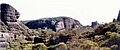
Monolith Valley
-
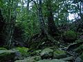
Budawangs subtropical rain forest
-
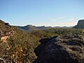
View across the Budawangs from Hidden Valley
-
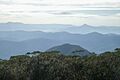
View from Mount Budawang towards Pigeon House Mountain
-
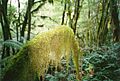
Moss at the rainforest at Mount Budawang


