
Regions of New South Wales facts for kids
New South Wales (NSW) in Australia has many areas known by special names called regions. A region is a part of land that shares similar features. These features can be natural, like the Murray River, the coast, or the Snowy Mountains. They can also be cultural, like areas where people grow grapes for wine (this is called viticulture). NSW is divided into many regions based on these different features. Sometimes, different groups use the same boundaries for their regions.
Contents
How Australia Counts Its Regions
The Australian Bureau of Statistics (ABS) is like a national scorekeeper. It collects and shares information about Australia, including its population and how people live. To do this, the ABS uses a special system to divide Australia into different areas. This system is called the Australian Statistical Geography Standard.
The ABS divides geography into different levels, like a set of nesting dolls:
- Statistical Area Level 4: These are the largest regions within a state. Think of them as big chunks of NSW.
- Statistical Area Level 1, 2, and 3: These are smaller areas within the Level 4 regions.
- Mesh Blocks: These are the tiniest areas, even smaller than Level 1. They are mostly used for detailed population counts, like the Census.
The ABS uses these areas to report important numbers, such as how many people live in each region. This helps us understand how different parts of NSW are growing and changing.
Older Ways of Counting Regions
Before the new system, the ABS used another way to define regions, called the Australian Standard Geographical Classification (AGSC). This system also had different levels:
- Census Collection District (CCD): These were the smallest areas.
- Statistical Local Area (SLA): These were made by combining CCDs. They often matched the boundaries of Local Government Areas (LGAs), which are like local councils.
- Statistical Divisions (SD): These were larger regions used to study social, population, and economic information. They were based on how people lived and worked.
- Statistical Regions (SR): These were created to study the workforce, like how many people had jobs.
- Statistical Districts (SDist): These were urban areas (cities and towns) with 25,000 people or more. They were planned to consider how much the area might grow in the next 20 years.
Natural Regions of Australia
Australia also has natural regions based on its environment. One important system is the Interim Biogeographic Regionalisation for Australia (IBRA). This system divides Australia into 89 large natural areas called bioregions, and 419 smaller subregions.

Each bioregion is a land area with similar ecosystems. An ecosystem is a community of living things (like plants and animals) and their non-living environment (like soil, water, and air) interacting together. These bioregions and subregions can cross state and territory borders.
Some of the bioregions found in NSW include:
- Australian Alps (part)
- Brigalow Belt South (part)
- Broken Hill Complex (part)
- Channel Country (part)
- Cobar Peneplain
- Darling Riverine Plains (part)
- Flinders Lofty Block (part)
- Mulga Lands (part)
- Murray Darling Depression (part)
- Nandewar (part)
- New England Tablelands
- NSW North Coast
- NSW South Western Slopes (part)
- Riverina (part)
- Simpson Strzelecki Dunefields (part)
- South East Corner (part)
- South Eastern Highlands (part)
- South East Queensland (part)
- Southern Volcanic Plain (part)
- Sydney Basin (Cumberland Plain)
Everyday Regions of NSW
Besides the official ways of dividing NSW, there are also informal regions. These regions don't have a specific government role and their boundaries can be a bit blurry. Different government departments, like the New South Wales Police Force or the Ministry of Health, might define regions differently for their own work.
The original idea for these informal regions comes from the natural geography of NSW. The state can be thought of as having four main parts:
- The coastal regions along the Tasman Sea in the east.
- The highlands, which are part of the Great Dividing Range.
- The western slopes of the highlands, which are important for farming.
- The dry western plains.
These four parts are often divided further into northern, central, and southern sections, usually based on their location compared to Sydney. This creates many of the common regional names you hear.
Here are some of the informal regions of NSW:
- North Coast
- Mid North Coast: This area stretches from Port Stephens up to Woolgoolga, near Coffs Harbour. Coffs Harbour and Port Macquarie are smaller cities here.
- Northern Rivers: This is north of Woolgoolga, all the way to the Queensland border. Towns include Casino and the popular tourist spot Byron Bay. Tweed Heads is a small city right on the border, next to the larger Queensland city of Gold Coast. Lismore is another small city. The weather here is humid and warm, with mild winters.
- Central Coast
- Central Coast: This area is north of the Hawkesbury River up to Lake Macquarie.
- Hunter: Located between the Mid North Coast and the Central Coast. It includes the valley of the Hunter River, which goes far inland. It also has the Newcastle–Lake Macquarie area, which is the second-largest urban area in NSW.
- South Coast
- Illawarra: This coastal region is between Royal National Park and Gerroa. It includes the Wollongong-Shellharbour area, the third-largest urban area in NSW, and smaller towns like Kiama and Gerringong.
- South Coast: East of Monaro and south of Gerroa, extending to the Victorian border. It has the small city of Nowra and major towns like Ulladulla, Bateman's Bay, Merimbula, and Eden. As you go south, it becomes more wild and forested.
- Northern Tablelands
- New England: This area includes towns like Tenterfield, Glen Innes, Guyra, Inverell, Armidale, and Walcha.
- Northern Tablelands: This name is also used for the broader region.
- Central Tablelands
- Greater Blue Mountains Area: This is generally west of the Nepean River and east of Lithgow. Most of this region is covered by national parks.
- Central West: This region is centered around the cities of Bathurst and Orange. It also includes towns like Cowra, Parkes, Lithgow, Oberon, Mudgee, and Forbes.
- Southern Tablelands
- Snowy Mountains
- North-West Slopes
- North-West Slopes: This region is in the northeast of the state, west of the Northern Tablelands. It's a hilly, inland area with a mild climate. The mid-sized city of Tamworth is here, along with towns like Moree, Gunnedah, and Coonabarabran.
- South-West Slopes
- Riverina: This region is in the central south of NSW, around the Murray River (which forms the border with Victoria), Murrumbidgee, and Lachlan rivers. Its exact borders can be unclear. If Albury is included, it's the largest city. Other cities and towns often considered part of the Riverina include Wagga Wagga, Griffith, Narrandera, Leeton, Gundagai, Temora, Cootamundra, and Hay.
- South-West Slopes: This name is also used for the broader region.
- Far West
- Far West: The only city here is Broken Hill. Other important towns are Bourke, Brewarrina, Cobar, Ivanhoe, and Wentworth. It has a dry, semi-arid climate that becomes a hot desert near Broken Hill. Wilcannia, a small town with many Aboriginal people, is the only major settlement between Cobar and Broken Hill.
- Orana
- Sydney Metropolitan
- Greater Sydney: This is the large urban area of Sydney. It includes many different sub-regions like North-Westerly, South-West, Central-West, Eastern Suburbs, and Northern Beaches. It covers 33 local government areas. Major districts include Liverpool, Blacktown, Fairfield, Parramatta, Bankstown, Auburn, Penrith, Campbelltown, Hurstville, Cronulla, Mascot, Katoomba, Hornsby, and Manly.
Regions for Specific Uses
Weather Forecasts
The Australian Bureau of Meteorology divides NSW into sixteen districts for weather forecasting. These are:
- Northern Rivers
- Mid North Coast
- Hunter (including the Central Coast)
- Northern Tablelands
- Sydney Metropolitan
- Illawarra
- South Coast
- Central Tablelands
- Southern Tablelands
- Snowy Mountains
- North West Slopes & Plains
- Central West Slopes & Plains
- South West Slopes
- Riverina
- Lower Western
- Upper Western
Travel Regions in Australia
When you look at travel guides for Australia, NSW might be divided into regions in yet another way. For example:
- Sydney
- Central Coast
- Hunter
- Blue Mountains
- Southern Highlands
- Snowy Mountains
- Illawarra
- South Coast
- Capital Country (similar to Southern Tablelands)
- Northern Rivers
- North Coast NSW (which is often called Mid North Coast in other lists)
- New England North West (Northern Tablelands and North West Slopes)
- Central New South Wales
- Riverina
- The Murray
- Outback New South Wales
This travel classification sometimes divides regions that are usually grouped together, like "The Riverina" being split into "Riverina" and "The Murray". Also, the "Blue Mountains" is listed as its own region, even though it's often considered part of the "Sydney" area.
Images for kids
-
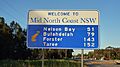
This sign welcomes travelers to the Mid North Coast, even though it's geographically in the Hunter Region. This shows how some regions are defined for commercial reasons.

