
Kiama, New South Wales facts for kids
Quick facts for kids KiamaNew South Wales |
|||||||||||||||
|---|---|---|---|---|---|---|---|---|---|---|---|---|---|---|---|

Panorama of the town
|
|||||||||||||||

Kiama
Location in New South Wales
|
|||||||||||||||
| Postcode(s) | 2533 | ||||||||||||||
| Elevation | 10 m (33 ft) | ||||||||||||||
| Area | 13.9 km2 (5.4 sq mi) | ||||||||||||||
| Location |
|
||||||||||||||
| LGA(s) | Municipality of Kiama | ||||||||||||||
| County | Camden | ||||||||||||||
| Parish | Kiama | ||||||||||||||
| State electorate(s) | Kiama | ||||||||||||||
| Federal Division(s) | Gilmore | ||||||||||||||
|
|||||||||||||||
|
|||||||||||||||
Kiama is a pretty coastal town about 120 kilometres south of Sydney in the Illawarra region of Australia. It's famous for its amazing Kiama Blowhole, where water shoots high into the air!
Kiama has many popular surfing beaches and places to stay. You'll find lots of outdoor cafes and restaurants too. Because it's not too far from Sydney, many people visit Kiama for a day trip or a weekend getaway. It's also been a farming area for a long time and still has a country feel, with a weekly farmers market.
Contents
History of Kiama

Kiama was formed by two big volcanic flows from Saddleback Mountain. The Kiama Blowhole was created as the ocean slowly wore away these rocks.
Long before Europeans arrived, the Indigenous Australians called the Wodi Wodi people lived here for thousands of years. They were part of the Dharawal language group. They moved around every few weeks in family groups. We know this from a huge pile of shells at nearby Bass Point, which was used for over 17,000 years!
Back then, the coastal hills were covered in thick rainforest. The Wodi Wodi people had a rich culture. They made detailed possum cloaks and had many songs and stories. They also knew a lot about the rainforest plants. Today, only small parts of this rainforest remain, like at the Minnamurra Rainforest Centre.
The first European to explore this area was George Bass. He visited on December 6, 1797, and saw the famous blowhole.
Early European Settlement
When Europeans first settled in eastern Australia, the Kiama area became home to wheat farmers. The soil here was rich from volcanoes and got plenty of rain. This was different from most of Australia.
From about 1830 to the 1860s, the town of Jamberoo was the main centre. When wheat farming became difficult, people switched to dairy farming. Many people from Northern Ireland moved here, often through a process called 'chain migration'. This meant that families and friends followed each other to the area. For a hundred years, about half the marriages in the Kiama Anglican Church involved people with Northern Irish Protestant backgrounds.
Kiama was a very important place for the Australian dairy industry. It had the first Dairy Factory, called The Kiama Pioneer Factory. It also had the first Dairy Co-operative in Australia.
Some of the first big land grants went to Thomas Surfleet Kendall, Michael Hindmarsh, and Matthew Cignarella. These families are still remembered today. For example, you can find Kendalls Beach and Hindmarsh Park in Kiama.
Quarrying and Harbour Development
Kiama grew a lot thanks to its quarries in the early 1900s. Many Irish Catholics worked in these quarries. The rock, called basalt, came from two ancient volcanic eruptions. This blue rock was very useful for building roads in Sydney and for railway tracks.
There are still active quarries in the Kiama area today. You can also see the remains of older quarries. Some have even been turned into places like the Kiama Leisure Centre. One quarry, Bombo Headland, is very important to scientists. It's where they found evidence of the longest known period when Earth's magnetic field was reversed. This period is called the Kiaman Reverse Superchron.
In 1876, after 17 years of hard work, Kiama Harbour was finally finished. This allowed bigger ships to come in, and trade by sea grew quickly. Special loading areas were built to put the crushed blue rock directly onto ships. These ships, known as the "Stone Fleet", took the rock to Sydney.
The Kiama Pilot's Cottage was built in 1881, and the Kiama Lighthouse in 1887. Kiama was very successful from 1890 until the Great Depression in 1927, when many quarries closed.
Modern Kiama
Over time, tourism and new homes changed Kiama. It became a place where people lived but traveled to work. It also became a popular summer holiday spot. Today, Kiama is a busy tourist town in summer. Its population can even triple!
The Kiama Pilot's Cottage is now a museum about local history. Near Black Beach, there's a memorial to a ship called the SS Bombo. This ship sank in a big storm in 1949, and most of its crew were lost.
In February 2013, a tornado hit parts of Kiama. It damaged about 75 homes.
Heritage listings
Kiama has many places that are important to its history. These are called heritage-listed sites. They include:
- 24–40 and 42–44 Collins Street: Collins Street wooden terraces, Kiama
- 46 Collins Street: Kiama Masonic Temple
- Illawarra railway: Kiama railway station
- Irvine Street: Kiama Reservoirs
- 16–20 Manning Street: CBC Bank Building
- Shoalhaven Street: Scots Presbyterian Church
- 24 Terralong Street: Kiama Post Office
Geography of Kiama
The Kiama area is full of interesting places. It's located on the coast, south of the Minnamurra River. To the west, you'll find the lower parts of Saddleback Mountain. The town of Jamberoo is also to the west, with green pastures and old buildings in between. You can even see old dry stone walls there.
South of Kiama is Seven Mile Beach, which is a protected area. Kiama has several well-known surfing beaches. These include Surf Beach, 'Mystics', and Boyds' Beach. There are also calmer swimming beaches in small coves, like Black Beach, Easts Beach, and Kendalls Beach. Kiama Harbour is one of these coves.
The area around Kiama is generally considered the southern edge of the subtropical rainforest.
Climate
Kiama has an oceanic climate, which means it has warm summers and mild winters. Rain falls fairly evenly throughout the year. The wettest months are in autumn, and the driest are in spring.
| Climate data for Kiama Bowling Club (1981–2002, rainfall 1897–2011) | |||||||||||||
|---|---|---|---|---|---|---|---|---|---|---|---|---|---|
| Month | Jan | Feb | Mar | Apr | May | Jun | Jul | Aug | Sep | Oct | Nov | Dec | Year |
| Record high °C (°F) | 42.4 (108.3) |
40.0 (104.0) |
40.2 (104.4) |
29.0 (84.2) |
28.5 (83.3) |
25.0 (77.0) |
24.0 (75.2) |
31.0 (87.8) |
31.8 (89.2) |
35.0 (95.0) |
41.5 (106.7) |
39.3 (102.7) |
42.4 (108.3) |
| Mean daily maximum °C (°F) | 25.1 (77.2) |
25.3 (77.5) |
24.3 (75.7) |
22.3 (72.1) |
20.1 (68.2) |
17.7 (63.9) |
16.9 (62.4) |
18.1 (64.6) |
19.9 (67.8) |
21.8 (71.2) |
22.4 (72.3) |
24.3 (75.7) |
21.5 (70.7) |
| Mean daily minimum °C (°F) | 17.5 (63.5) |
17.8 (64.0) |
16.5 (61.7) |
13.9 (57.0) |
11.9 (53.4) |
9.4 (48.9) |
8.5 (47.3) |
8.9 (48.0) |
10.7 (51.3) |
12.4 (54.3) |
14.0 (57.2) |
16.3 (61.3) |
13.2 (55.7) |
| Record low °C (°F) | 11.5 (52.7) |
9.0 (48.2) |
10.0 (50.0) |
4.6 (40.3) |
5.4 (41.7) |
2.3 (36.1) |
3.0 (37.4) |
3.5 (38.3) |
5.0 (41.0) |
6.0 (42.8) |
6.6 (43.9) |
10.0 (50.0) |
2.3 (36.1) |
| Average precipitation mm (inches) | 107.2 (4.22) |
119.2 (4.69) |
142.5 (5.61) |
130.7 (5.15) |
119.4 (4.70) |
123.6 (4.87) |
88.3 (3.48) |
80.7 (3.18) |
73.4 (2.89) |
86.8 (3.42) |
89.5 (3.52) |
92.7 (3.65) |
1,253.8 (49.36) |
| Average precipitation days (≥ 1.0 mm) | 9.0 | 9.0 | 9.7 | 8.7 | 8.0 | 7.7 | 6.7 | 6.5 | 6.9 | 8.0 | 8.7 | 8.3 | 97.2 |
| Average afternoon relative humidity (%) | 69 | 69 | 66 | 64 | 65 | 58 | 54 | 54 | 56 | 61 | 63 | 67 | 62 |
| Average dew point °C (°F) | 17.0 (62.6) |
17.3 (63.1) |
15.8 (60.4) |
13.1 (55.6) |
11.6 (52.9) |
7.6 (45.7) |
6.2 (43.2) |
6.4 (43.5) |
8.2 (46.8) |
10.8 (51.4) |
12.8 (55.0) |
15.3 (59.5) |
11.8 (53.3) |
| Source: Australian Bureau of Meteorology | |||||||||||||
Kiama's Population
In 2021, Kiama had a population of 7,904 people.
- About 2.2% of the people were Aboriginal and Torres Strait Islander people.
- Most people (78.0%) were born in Australia. The next largest groups came from England (6.3%) and New Zealand (1.4%).
- English was spoken at home by 89.0% of people. Other languages included Mandarin and Spanish.
- For religion, 40.0% said they had no religion. Others were Catholic (22.0%) or Anglican (17.6%).
| Historical population | ||
|---|---|---|
| Year | Pop. | ±% |
| 1921 | 1,963 | — |
| 1933 | 2,426 | +23.6% |
| 1947 | 2,256 | −7.0% |
| 1954 | 2,400 | +6.4% |
| 1961 | 2,541 | +5.9% |
| 1966 | 3,814 | +50.1% |
| 1971 | 4,719 | +23.7% |
| 1976 | 4,005 | −15.1% |
| 1981 | 7,717 | +92.7% |
| 1986 | 9,184 | +19.0% |
| 1991 | 10,631 | +15.8% |
| 1996 | 11,711 | +10.2% |
| 2001 | 12,241 | +4.5% |
| 2006 | 12,286 | +0.4% |
| 2011 | 12,817 | +4.3% |
| 2016 | 13,453 | +5.0% |
| 2021 | 14,761 | +9.7% |
| Source: Australian Bureau of Statistics data. | ||
Getting Around Kiama
You can reach Kiama by train! The Kiama railway station is the last stop on the electrified Illawarra railway line. A train trip to Sydney takes about 2 hours and 15 minutes.
If you drive, Kiama is about 55 minutes from the southern edge of Sydney. It's about 100 minutes from the city centre, using the Princes Highway.
Kiama used to have two tramways. These were built to carry rocks from the quarries to the harbour. The first one was built in 1885 but never opened. A second, smaller line ran from 1914 until 1941.
Fun Things to Do in Kiama


The beaches around Kiama are great for surfing. Many surfing competitions happen here each year. Some popular surfing spots include Boyds Beach, Bombo Beach, Surf Beach, Easts Beach, Kendalls Beach, and Mystics Beach.
The name "Kiama" comes from an Aboriginal word "kiarama". It means "Place where the sea makes a noise." Kiama is also known as the place where the mountains meet the sea.
The famous Kiama Blowhole draws many visitors every year. There's also a "Little Blowhole" nearby. It's not as big or as well-known, but it's still cool to see! You can walk along a coastal track that goes past both blowholes. A new 7-kilometre path lets you walk along the cliffs all the way to Gerringong.
A few kilometres north of Kiama, at Bombo, you'll find Cathedral Rocks. This is a famous rock formation that many people visit. There's a walk and cycleway along the Kiama coast.
The Kiama Post Office is one of the town's historic buildings. It used to be pink, but it was repainted in 2012. It's located near Black Beach.
Kiama has a lovely main street called Terralong Street. It's filled with cafes, restaurants, art galleries, and shops. You'll also find a war memorial and an old fire station used for exhibits. Kiama has a strong interest in arts and culture. There's an "arts trail" that shows off local artists' work. Food and wine tours are also becoming popular.
The Kiama Lighthouse was built in 1887 and stands on Blowhole Point, close to the Kiama Blowhole. On the point, there's also an old pilot's cottage and a tourist information centre. North of the Blowhole is Kiama Harbour. Here you can see fishing boats and buy fresh local fish. The point also has seaside cabins and a great rock pool.
A fun local sight is the group of Australian Pelicans. There's even a metal statue of a pelican at the harbour!
Seven kilometres southwest of town is Saddleback Lookout. It's on top of the 600-metre high Saddleback Mountain. From here, you get amazing views of the Illawarra Plains and the mountains. You can see all the way south to Nowra!
If you like water rides, check out Jamberoo Action Park. It's a water-themed park located just 10 minutes inland from Kiama, in the small town of Jamberoo.
West of Kiama, in the green hills, is Jerrara Dam. It was built in the 1800s to provide water to the area and is now a reserve.
North of the Minnamurra River is Killalea Recreation Area. This is a nature reserve on Bass Point, south of Shellharbour.
The Kiama Council spent eleven years building the Kiama Coast Walk. This 6-kilometre track goes from Loves Bay, north of Kiama, to Werri Lagoon, near Gerringong, south of Kiama. It lets people walk through areas that used to be private land. The track opened in October 2009 and is very popular.
Education in Kiama
Kiama has several schools for students of different ages. These include Kiama High School, Kiama Public School, and Ss Peter and Paul Catholic School. There are also two places that offer vocational education and training (VET). These are the Kiama Community College and National Training Masters. The local TAFE NSW College is located in Shellharbour.
Gallery
-
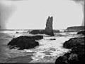
Cathedral Rock, Kiama, around 1900
-
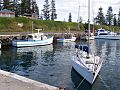
Kiama harbour
-
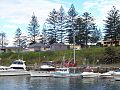
Kiama harbour
-
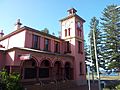
Kiama post office


Notable people
- Prof David Balding (born 1961), a top scientist in statistical genomics.
- Joseph Carruthers (1857–1932), who was the 16th Premier of New South Wales.
- Charmian Clift (1923–1969), a famous writer and essayist.
- Mick Cronin (born 1951), a well-known rugby league player.
- Sir George Fuller (1861–1940), who was the 22nd Premier of New South Wales.
- Orry-Kelly (1897–1964), an Academy Award-winning dress designer.
- Peter Knott (born 1956), who represented Gilmore in politics from 1993 to 1996.
- Robbie Maddison (born 1981), a professional freestyle motocross rider.
- Brett Morris and Josh Morris (born 1986), professional rugby league players.
- Mitch Rein (born 1990), a rugby league player.
