Katoomba, New South Wales facts for kids
Quick facts for kids KatoombaNew South Wales |
|||||||||||||||
|---|---|---|---|---|---|---|---|---|---|---|---|---|---|---|---|
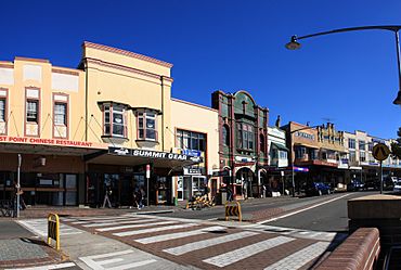
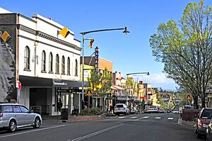
Katoomba Street, Katoomba commercial area
|
|||||||||||||||
| Population | 8,268 (2021 census) | ||||||||||||||
| Established | 1879 | ||||||||||||||
| Postcode(s) | 2780 | ||||||||||||||
| Elevation | 1,017 m (3,337 ft) | ||||||||||||||
| Location |
|
||||||||||||||
| LGA(s) | City of Blue Mountains | ||||||||||||||
| County | Cook | ||||||||||||||
| State electorate(s) | Blue Mountains | ||||||||||||||
| Federal Division(s) | Macquarie | ||||||||||||||
|
|||||||||||||||
|
|||||||||||||||
Katoomba is a lively town in the Blue Mountains of New South Wales, Australia. It's the main town and important centre for the City of Blue Mountains area. Katoomba sits on the traditional lands of the Dharug and Gundungurra Aboriginal peoples.
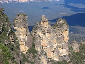
This town is located on the Great Western Highway. It's famous for the Three Sisters rock formation. Katoomba is about 102 km (63 mi) west of Sydney Central Business District and 39 km (24 mi) south-east of Lithgow. You can also reach it by train, as Katoomba railway station is on the Main Western line.
Katoomba is a great starting point for exploring the beautiful Blue Mountains through bushwalks and nature trips. In 2021, about 8,268 people lived in Katoomba.
Contents
What Does the Name Katoomba Mean?
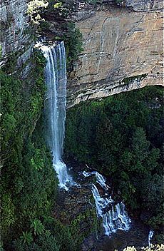
The name "Katoomba" comes from an Aboriginal term, Kedumba or Katta-toon-bah. This means "shining falling water" or "water tumbling over hill." It refers to a waterfall that drops into the Jamison Valley.
Before it was called Katoomba, the area had other names like William's Chimney and Collett's Swamp. In 1874, it was known as The Crushers, named after a railway station that served a nearby quarry. The name Katoomba was officially chosen in 1877. The town became a municipality (its own local government area) in 1889.
A Brief History of Katoomba
For thousands of years, the Blue Mountains were home to Aboriginal peoples, especially the Gundungurra and Darug tribes. They called the area kedumba, which meant shiny, falling waters. Sadly, many were forced to leave their homes due to unfair policies in the early 1900s. Some moved to places like The Gully, an area in north Katoomba.
Today, many Aboriginal people still live in the Blue Mountains. There are cultural sites that teach visitors about the region's rich past. These sites share the customs and history of the local tribes.
Katoomba and nearby Medlow Bath started to become popular tourist spots in the late 1800s. Many hotels were built and made bigger over time to welcome visitors.
Mining for coal and oil shale also happened in the Jamison Valley for many years. But by the early 1900s, these resources ran out. By then, Katoomba was already a well-known resort town. In the 1960s, Katoomba became less popular, and some guesthouses were used for other things, like hospitals.
However, in the 1980s, guesthouses and hotels became popular again. Many were fixed up and brought back to their original beauty.
In 2012, The Gully was officially declared an "Aboriginal place." This means it's a very important site for Aboriginal culture. This was done under the National Parks and Wildlife Act 1974.
Katoomba's Climate and Weather
Katoomba has an oceanic climate (Cfb). This means it has mild summers and cool to cold winters. In summer, daytime temperatures are usually around 20°C. They rarely go above 30°C. Night-time temperatures are usually around 10-15°C.
In winter, the highest temperature is usually about 10 °C (50 °F). The lowest temperature is often around 0 °C (32 °F) on clear nights. On cloudy nights, it's usually around 3 to 4 °C (37 to 39 °F). Katoomba usually gets two or three snowfalls each year. Temperatures are about 7 °C (13 °F) lower than in Sydney. Many days are misty. Katoomba has about 79.8 clear days each year.
Snowfall in the Blue Mountains
The Blue Mountains are known for snow in winter. However, despite the cold, there are only about five snowy days each year in the upper mountains. It's very rare to see snow below Lawson. It's common to see thick frost covering the ground in the early mornings. In the evening, cars can get a thick layer of ice on their windscreens.
Winters here are not as snowy or rainy as places like Orange and Oberon to the west. This is because Katoomba is mostly on the eastern side of the mountains. This means it gets a moderate foehn effect, which makes it a bit drier.
There have been some big snowfalls in Katoomba's history.
- On 5 July 1900, snowdrifts were over 1.8 metres (6 ft) deep in some parts of the Blue Mountains. The snow and ice caused big problems. Roads and railways closed, buildings were damaged, and telegraph services stopped.
- A winter storm on 17 July 1965 also brought very heavy snow and ice. This caused damage to buildings and made travel very difficult.
- More recently, on 17 July 2015, a cold snap brought up to 20 cm of snow to Katoomba. This was the heaviest snowfall in many years.
| Climate data for Katoomba (Farnells Road, 1991–2020); 1,017 m AMSL; 33.71° S, 150.30° E | |||||||||||||
|---|---|---|---|---|---|---|---|---|---|---|---|---|---|
| Month | Jan | Feb | Mar | Apr | May | Jun | Jul | Aug | Sep | Oct | Nov | Dec | Year |
| Record high °C (°F) | 39.8 (103.6) |
38.8 (101.8) |
34.0 (93.2) |
29.6 (85.3) |
22.9 (73.2) |
19.4 (66.9) |
18.8 (65.8) |
22.0 (71.6) |
28.6 (83.5) |
31.2 (88.2) |
36.0 (96.8) |
39.5 (103.1) |
39.8 (103.6) |
| Mean daily maximum °C (°F) | 24.2 (75.6) |
22.9 (73.2) |
20.7 (69.3) |
17.8 (64.0) |
14.1 (57.4) |
10.9 (51.6) |
10.6 (51.1) |
12.2 (54.0) |
15.6 (60.1) |
18.5 (65.3) |
20.6 (69.1) |
22.6 (72.7) |
17.6 (63.7) |
| Daily mean °C (°F) | 18.9 (66.0) |
18.2 (64.8) |
16.2 (61.2) |
13.4 (56.1) |
10.2 (50.4) |
7.5 (45.5) |
6.8 (44.2) |
7.8 (46.0) |
10.7 (51.3) |
13.3 (55.9) |
15.4 (59.7) |
17.3 (63.1) |
13.0 (55.4) |
| Mean daily minimum °C (°F) | 13.5 (56.3) |
13.4 (56.1) |
11.7 (53.1) |
9.0 (48.2) |
6.3 (43.3) |
4.1 (39.4) |
2.9 (37.2) |
3.4 (38.1) |
5.8 (42.4) |
8.0 (46.4) |
10.1 (50.2) |
11.9 (53.4) |
8.3 (46.9) |
| Record low °C (°F) | 4.2 (39.6) |
3.9 (39.0) |
1.7 (35.1) |
−0.5 (31.1) |
−2.8 (27.0) |
−8.2 (17.2) |
−5.4 (22.3) |
−5.6 (21.9) |
−2.8 (27.0) |
−1.0 (30.2) |
−0.1 (31.8) |
2.4 (36.3) |
−8.2 (17.2) |
| Average precipitation mm (inches) | 147.6 (5.81) |
209.9 (8.26) |
168.2 (6.62) |
87.2 (3.43) |
79.8 (3.14) |
104.9 (4.13) |
55.0 (2.17) |
66.2 (2.61) |
63.6 (2.50) |
90.2 (3.55) |
131.9 (5.19) |
111.9 (4.41) |
1,309.2 (51.54) |
| Average precipitation days (≥ 0.2 mm) | 16.3 | 15.7 | 15.6 | 11.5 | 10.1 | 12.2 | 10.6 | 9.8 | 10.1 | 12.1 | 15.6 | 14.7 | 154.3 |
| Average afternoon relative humidity (%) | 61 | 66 | 65 | 63 | 69 | 71 | 67 | 57 | 54 | 53 | 59 | 57 | 62 |
| Source 1: Temperatures and rain data: 1991–2020; Relative humidity: 1991–2020 |
|||||||||||||
| Source 2: Extremes: 1957–2020 |
|||||||||||||
People and Culture in Katoomba
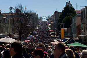
Katoomba's beautiful scenery and unique shops attract a creative and alternative community. Many poets, artists, and environmentalists live here. The town hosts the Winter Solstice festival, called Winter Magic. This festival shows off local talent, art, and handmade crafts. It started in 1994 to celebrate winter in the Blue Mountains.
The festival is part of a bigger event called Yulefest. Yulefest is a long-running tourism idea that promotes Christmas celebrations in the Australian winter (June to August). It's like having a Northern Hemisphere Christmas in the middle of the year!
Many famous people have lived or worked in Katoomba:
- Novelist and historian Eleanor Dark (1901–1985) lived in Katoomba from 1923 until she passed away. Her home, "Varuna," is now Varuna, The Writers' House. It's a special place for writers.
- In 1921, filmmakers Raymond Longford and Lottie Lyell shot parts of their movie The Blue Mountains Mystery around the town.
- Ursula Dubosarsky's 1991 time-travel novel Zizzy Zing is set in Katoomba in 1938.
- Poet and author Steven Herrick set his novel 'The Bogan Mondrian' and his verse-novel 'love, ghosts and nose-hair' in modern-day Katoomba.
- Blues musician Claude Hay also lives in Katoomba. He built his home and recording studio here. His albums, Kiss the Sky (2007) and Deep Fried Satisfied (2010), were recorded in Katoomba. The second album was very popular, reaching No. 1 on an Australian music chart.
Besides its alternative culture, Katoomba is home to many different families. It also has a large Aboriginal population. Catalina Park, also known as The Gully, was declared an Aboriginal Place in 2002. It's a special area for both nature and culture. It has a long history of being lived in by the Gundungurra and Darug tribes.
The Gundungurra Tribal Council Aboriginal Corporation is based in Katoomba. This group helps represent the Gundungurra traditional owners. They work to promote Aboriginal heritage and culture. They also support Gundungurra people in connecting with their traditional lands.
Katoomba has its own local community radio station, 89.1 Radio Blue Mountains. The local cinema is called The Edge, located on the Great Western Highway. Since 2014, Katoomba has hosted the Vertical Film Festival every two years. There's also a lively music and theatre scene in town.
Who Lives in Katoomba?
The 2021 census showed that 8,268 people live in Katoomba. Here's a quick look at who makes up the community:
- About 3.3% of the population are Aboriginal and Torres Strait Islander people.
- Most people have English (42%), Australian (31.1%), Irish (17.6%), Scottish (13.9%), or German (6%) backgrounds.
- About 73.3% of people were born in Australia. The next most common birthplaces were England (5.6%) and New Zealand (2.0%).
- Most people (86%) speak only English at home.
- When it comes to religion, 55.4% said they had no religion. Catholic was 12.4%, and Anglican was 9.5%.
- The average age in Katoomba is 48 years old. This is older than the national average of 38 years.
- Children under 15 make up 13.8% of the population. People aged 65 and over make up 23.6%.
- The average household income per week was $1,171. This is less than the national average of $1,746.
- About 55.4% of households are families. 39.5% are single-person households, and 5.1% are group households. The average household size is 2.1 people.
Tourism in Katoomba
Katoomba's main business is tourism. People come from all over to see its amazing mountain scenery. The famous rock formation called the Three Sisters is a huge draw. You can see it from Echo Point, which is about 2 kilometres (1.2 mi) south of the town. Thousands of visitors come here every year.
From Echo Point, you can also see other cool features of the Jamison Valley. These include Mount Solitary and a rock formation called the Ruined Castle. A short walk from Echo Point leads to the Giant Stairway. This stairway takes you to many nature walks through the Valley. Some of these tracks were closed for repairs, but most are open again. The area has lots of dense, warm rainforest, hanging swamps, and beautiful waterfalls.
Another big attraction is Scenic World. This is a tourist park in the southwest of town. It has the steepest funicular railway in the world, the Katoomba Scenic Railway. This railway was first built to help with coal and oil shale mining. Scenic World also has the Scenic Skyway cable car. This cable car travels over a part of the Jamison Valley. It gives you amazing views of Katoomba Falls and Orphan Rock. In 2004, the old Skyway car was replaced. The new one has a special floor that becomes transparent (see-through) as the car moves!
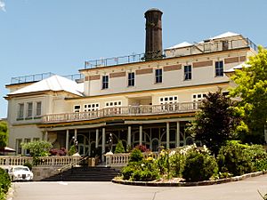
Katoomba has many hotels and guesthouses. The oldest is the Carrington Hotel, built in 1882. It sits on the highest point in town. The town centre, especially Katoomba Street, has many cafes and restaurants. The Paragon, a famous cafe, dates back to the early 1900s. You can also find many second-hand book and antique stores here.
Getting Around Katoomba
Katoomba was connected to the Main Western railway line in 1874. Back then, the station was called "The Crushers." Now, Katoomba railway station is served by the Blue Mountains Line. The weekly Outback Xplorer train from Sydney to Broken Hill also stops in Katoomba.
The Great Western Highway is the main road for getting to Katoomba.
There's also Katoomba Airfield, about 11.5 kilometres (7.1 mi) from the town centre. This airfield is currently closed to regular planes and helicopters. However, it can still be used by emergency services.
Historic Places in Katoomba
Katoomba has several places listed as heritage sites. These are important buildings and areas that show the town's history. Some are listed on the New South Wales State Heritage Register:
- Blue Mountains National Park: Blue Mountains walking tracks
- 10-14 Civic Place: Mount St Marys College and Convent
- Katoomba Street: Carrington Hotel
- 59-61 Katoomba Street: Katoomba Post Office
- 63-69 Katoomba Street: Paragon Cafe, Katoomba; this is also listed on another heritage register.
- Main Western railway: Katoomba railway station
- 10-16 Panorama Drive: Lilianfels, Katoomba
Other important heritage sites include:
- Uniting Church: Located on Katoomba Street, this church was built in 1888. It shows a Gothic style that was popular for many years.
- Swiss Cottage: Built in 1898, this charming cottage was once a guesthouse. It's now called Pins on Lurline.
- Kapsalie: This home was built in 1915. The Varipatis family, who ran a seafood restaurant, named it Kapsalie after their hometown in Greece.
- Katoomba Court House: Built in 1897 from local sandstone, this building was designed by the Government Architect, Walter Liberty Vernon. It has been expanded several times as the town grew.
- Varuna: This house was built in 1939. It was the home of writer Eleanor Dark and her husband. It became a centre for writers in 1989, called Varuna, The Writers' House. The house, studio, and garden are all important heritage sites.
 | Delilah Pierce |
 | Gordon Parks |
 | Augusta Savage |
 | Charles Ethan Porter |


