
Blue Mountains National Park facts for kids
Quick facts for kids Blue Mountains National ParkNew South Wales |
|
|---|---|
|
IUCN Category II (National Park)
|
|
.jpg)
|
|

Blue Mountains National Park
Location in New South Wales
|
|
| Nearest town or city | Katoomba |
| Established | September 1959 |
| Area | 2,679.54 km2 (1,034.6 sq mi) |
| Visitation | 5,200,000 (in 2016) |
| Managing authorities | NSW National Parks & Wildlife Service |
| Website | Blue Mountains National Park |
| See also | Protected areas of New South Wales |
The Blue Mountains National Park is a special protected area in New South Wales, eastern Australia. It's about 80 kilometers (50 miles) west of Sydney. Even though it's called "mountains," the area is actually a high, flat land (a plateau) that has been carved out by rivers.
This national park is part of the Greater Blue Mountains Area. This larger area became a UNESCO World Heritage Site in 2000. This means it's recognized as a very important natural place globally. The Blue Mountains National Park is the main part of this World Heritage area. It's also part of the Great Dividing Range, a long chain of mountains in Australia.
Contents
History of the Park
-Location-Map.png)
The idea for the Blue Mountains National Park started a long time ago. A conservationist named Myles Dunphy first suggested creating a large park here in 1932.
The Blue Mountains National Park officially opened in September 1959. It covered a huge area of about 63,000 hectares (155,676 acres) at that time. Later, in 2000, it became part of the World Heritage Area. This helped protect its unique nature even more.
Many walking tracks in the Blue Mountains are also very old and important. In 1999, 37 of these tracks were added to the State Heritage Register. This means they are protected because of their history and importance. These tracks stretch across the region, from Glenbrook in the east to Jenolan Caves in the west.
Geography of the Blue Mountains
The Blue Mountains National Park is located on the eastern side of the Great Dividing Range. The land gently slopes downwards from west to east. It goes from about 1,100 meters (3,600 feet) high near Mount Victoria to less than 200 meters (650 feet) near Glenbrook.
Four main rivers flow through the park. These are the Wollangambe River in the north, the Grose River in the middle, and the Coxs and Wollondilly rivers in the south. The Coxs and Wollondilly rivers flow into Lake Burragorang. This lake is just outside the park and is very important. It's where Warragamba Dam is, which provides most of Sydney's drinking water! All these major rivers flow from west to east.
Geology: How the Mountains Formed

The Blue Mountains are part of a larger area called the Sydney Basin. This basin is made of layers of sedimentary rock. These rocks were formed over millions of years from sand, mud, and other materials settling down.
About 50 million years ago, the land in this area was pushed upwards. This created the Blue Mountains and the Great Dividing Range. Later, some parts of the mountains were covered by basalt, a type of rock from volcanoes. Most of this volcanic rock has worn away over time, but you can still see small bits of it on some high peaks.
Amazing Plants and Animals
The park is home to many different types of eucalypt trees. You can find them in various habitats like wet and dry forests, swamps, and grasslands.
One of the most special plants here is the Wollemi Pine. This tree is incredibly rare, with fewer than 100 trees known in the wild! It's like a living fossil, giving us clues about how plants evolved. The park also has many other important plant families, including 114 species found nowhere else in the world.
The park's different habitats also support a wide variety of animals. About one-third of all Australia's bird species live here! You can also find many mammals, reptiles, and frogs. Some of the notable animals that are endangered or unique to this area include the Regent Honeyeater, the Broad-headed snake, and the Blue Mountains water skink.
Visiting the Blue Mountains National Park

The Blue Mountains National Park is the most visited national park in New South Wales. Many visitors come from Sydney. It's also one of the easiest places near Sydney to see wild kangaroos!
Most tourists enjoy the park from its many lookouts. These lookouts offer amazing views of cliffs and waterfalls, especially between Wentworth Falls and Blackheath. The cliffs in these areas are hundreds of meters tall and truly spectacular.
There are many fun things to do in the park:
- Short Walks: Take easy walks to stunning lookouts above cliffs and waterfalls.
- Longer Hikes: For those who love adventure, there are overnight and longer walks into more remote parts of the park.
- Extreme Sports: If you're looking for a thrill, you can try canyoning (exploring canyons), abseiling (climbing down ropes), rock climbing, and mountain biking. You can find tour companies that help visitors do these activities safely.
- Scenic World: The park is also home to the Katoomba Scenic Railway, which is known as the world's steepest railway!
The park is famous for the Three Sisters rock formation. This iconic landmark is a must-see for visitors. The number of people visiting the park has grown a lot, reaching 5.2 million in 2016.
Southern Blue Mountains Area
The national park stretches south towards the Wollondilly River, west of Mittagong. This southern part of the park was greatly changed when the Warragamba Dam was built between 1948 and 1960.
Building the dam meant flooding the Burragorang Valley. This created Lake Burragorang. This lake cut off the southern Blue Mountains from areas to the east, like Camden and Picton. Many old homes and farms in this area had to close down.
To protect Sydney's water supply, an area of about three kilometers (1.8 miles) around Lake Burragorang was made an exclusion zone. However, a special walking track was kept open for bushwalkers. This track goes from Yerranderie to Balloon Pass. It is now part of a longer walking route called the Katoomba to Mittagong Trail.
Images for kids
-
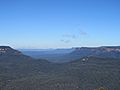
Mountain ranges at Three Sisters Walk Lookout.

See also
 In Spanish: Parque nacional Montañas Azules para niños
