
Lake Burragorang facts for kids
Quick facts for kids Lake Burragorang |
|
|---|---|

from the air (April 2006)
|
|

Lake Burragorang
Location in Australia

Lake Burragorang
Location in New South Wales
|
|
| Coordinates | 34°0′S 150°26′E / 34.000°S 150.433°E |
| Type | Man-made water supply dammed reservoir |
| Primary inflows | Coxs, Kowmung, Nattai, Wingecarribee, Wollondilly and Warragamba rivers |
| Primary outflows | Warragamba River |
| Catchment area | 9,051 km2 (3,495 sq mi) |
| Basin countries | Australia |
| Max. length | 52 km (32 mi) |
| Surface area | 75 km2 (29 sq mi) |
| Max. depth | 105 m (344 ft) |
| Water volume | 2,031 GL (4.47×10¹¹ imp gal; 5.37×10¹¹ US gal) |
| Shore length1 | 354 km (220 mi) |
| Surface elevation | 110 m (360 ft) |
| 1 Shore length is not a well-defined measure. | |

Lake Burragorang is a large, man-made lake in Australia. It was created by building a dam. This lake provides most of the drinking water for Sydney, a large city in New South Wales. It is located in the beautiful lower Blue Mountains.
The dam that holds back the water, called Warragamba Dam, is about 60 kilometers southwest of Sydney's city center. Lake Burragorang is part of the World Heritage Site known as the Greater Blue Mountains Area. This area is special because of its natural beauty.
The lake can hold about 2,031 gigalitres of water. It collects water from several rivers. These include the Coxs, Kowmung, Nattai, Wingecarribee, Wollondilly, and Warragamba rivers. All these rivers flow into the Nepean and Hawkesbury River system.
Contents
History of the Valley
Before the dam was built, the Burragorang Valley was home to people for thousands of years. The Gundungarra nation, an Indigenous tribe, lived in this valley. They also lived in the Blue Mountains and Megalong Valley.
White settlers started living in the valley in the 1800s. There were small farming towns and coal mines there. All these places are now underwater because of the lake. Building the Warragamba Dam started in 1948 and finished in 1960.
How Much Water Does the Lake Hold?
Lake Burragorang can hold a lot of water. Its usable capacity is about 2,027 gigalitres. In 2006, a project called "Deep Water Storage Recovery" was completed. This project helped the lake hold even more usable water.
Sydney's population is growing by about 50,000 people each year. This means more water is needed. Sometimes, during serious droughts, water restrictions are put in place. This means people have to limit how much water they use. Droughts are expected to happen more often in the future.
The lake's water level has been very low at times. On February 8, 2007, it reached its lowest point ever, at only 32.5% full. To help make sure Sydney always has enough water, the government built the Sydney Desalination Plant. This plant can turn seawater into fresh drinking water.
In March 2012, the dam reached its maximum capacity and spilled over. This was the first time it had happened in fourteen years. This shows that weather patterns are changing. We might see longer dry periods followed by shorter, heavier rainfalls.
In 2019, there was a plan to make the dam 14 meters taller. The idea was to help prevent floods in areas downstream. However, some people worried this might flood large areas of natural wildlife habitat. It could also flood native plants that help absorb carbon dioxide.
Visiting Lake Burragorang
To keep the water supply clean, there is a 3-kilometer wide area around Lake Burragorang where access is limited. This is called an "exclusion zone."
However, there are a couple of ways for bushwalkers to access parts of the area. You can walk from Coxs River to Mount Cookem. Another path is from Belloon Pass to Yerranderie. There is also limited vehicle access on a fire trail called W4, from Sheahys Creek to Yerranderie.
Power from the Dam
The Warragamba Dam also has a hydroelectric power station. This station can make electricity when the lake is almost full. It can produce 50 megawatts of power. However, the water level has not been high enough for it to operate since 1998.
Lake Facts and Figures
| Key Reservoir Statistics | |
|---|---|
| Available storage (when full) | 2,027 gigalitres (4.46×10¹¹ imp gal; 5.35×10¹¹ US gal) |
| Total capacity (when full) | 2,031 gigalitres (4.47×10¹¹ imp gal; 5.37×10¹¹ US gal) |
| Surface area | 75 square kilometres (29 sq mi) |
| Length of lake | 52 kilometres (32 mi) |
| Length of foreshores | 354 kilometres (220 mi) |
| Deepest point | 105 metres (344 ft) |
| Catchment area | 9,051 square kilometres (3,495 sq mi) |
| Average annual rainfall | 840 millimetres (33 in) |
Images for kids
-
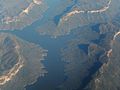
An aerial view of the lake
-
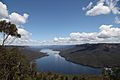
The lake viewed from the Lake Burragorang lookout
.jpg)

