Wingecarribee River facts for kids
Quick facts for kids Wingecarribee |
|
|---|---|

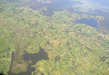
The brown on the left is Wingecarribee Swamp with Fitzroy Falls Reservoir on the right.
|
|
| Native name | Winge Karrabee |
| Country | Australia |
| State | New South Wales |
| Region | Sydney Basin (IBRA), Southern Highlands |
| Local government areas | Wingecarribee, Wollondilly |
| Town | Berrima |
| Physical characteristics | |
| Main source | Wingecarribee Reservoir Glenquarry 674 m (2,211 ft) 34°34′35″S 150°32′35″E / 34.576276°S 150.542985°E |
| River mouth | confluence with the Wollondilly River Tugalong, northwest of Berrima 280 m (920 ft) 34°22′36″S 150°07′22″E / 34.376703°S 150.122820°E |
| Length | 73 km (45 mi) |
| Basin features | |
| River system | Hawkesbury-Nepean catchment |
| Tributaries |
|
| National park | Bangadilly National Park |
The Wingecarribee River is a river in the Southern Highlands of New South Wales, Australia. It is a perennial river, meaning it flows all year round. The river is part of the larger Hawkesbury–Nepean river system.
The name Winge Karrabee comes from the Dharawal Aboriginal people. It means "a flight of birds" and "waters to rest beside."
Journey of the River
The Wingecarribee River starts high up near Robertson. Its journey begins below the Wingecarribee Reservoir, close to the village of Glenquarry.
The river flows mostly towards the northwest. Along its path, it is joined by two smaller streams, called tributaries. It also flows through the Belanglo State Forest and Bangadilly National Park. Finally, it meets the Wollondilly River north of Tugalong, which is northwest of Berrima. This meeting point is called a confluence.
Over its 73-kilometre (45-mile) course, the river drops about 393 metres (1,289 feet).
Wingecarribee Swamp
In its upper parts, the small creeks that feed the Wingecarribee River create the Wingecarribee Swamp. This swamp is special because it is the only large peat bog in New South Wales.
Sadly, most of the swamp has been drained. The part that is left is very important. It is home to several endangered species, which are animals and plants at risk of disappearing forever.
River Crossings
The Moss Vale Road crosses the Wingecarribee River at Bong Bong. This spot is located between the towns of Bowral and Moss Vale.
Further along, at Berrima, the river is crossed by the Hume Freeway.
Water Supply for Sydney
The Shoalhaven Scheme is a system that helps provide water to greater metropolitan Sydney. This scheme pumps water from the Shoalhaven River into the Wingecarribee Reservoir. This extra water helps make sure Sydney has enough water to drink and use.
 | John T. Biggers |
 | Thomas Blackshear |
 | Mark Bradford |
 | Beverly Buchanan |

