Wingecarribee Shire facts for kids
Quick facts for kids Wingecarribee ShireNew South Wales |
|||||||||||||||
|---|---|---|---|---|---|---|---|---|---|---|---|---|---|---|---|
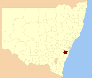
Location in New South Wales
|
|||||||||||||||
| Population |
|
||||||||||||||
| • Density | 17.807/km2 (46.12/sq mi) | ||||||||||||||
| Established | 1 January 1981 | ||||||||||||||
| Area | 2,689 km2 (1,038.2 sq mi) | ||||||||||||||
| Mayor | Duncan Gair [Suspended] | ||||||||||||||
| Council seat | Moss Vale | ||||||||||||||
| Region | Southern Highlands, Capital Country | ||||||||||||||
| State electorate(s) |
|
||||||||||||||
| Federal Division(s) |
|
||||||||||||||
 |
|||||||||||||||
| Website | Wingecarribee Shire | ||||||||||||||
|
|||||||||||||||
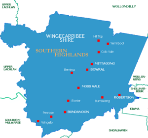
Wingecarribee Shire is a special area in the Southern Highlands of New South Wales, Australia. It's a local government area, which means it has its own council that helps manage the region.
The Shire is about 110 kilometers southwest of Sydney. It's known for its beautiful landscapes and is an important source of water for cities like Sydney, Wollongong, and the Northern Shoalhaven area.
The main office for the Council is in Moss Vale. However, the busiest town for shopping and businesses in the Shire is Bowral.
Wingecarribee Shire was formed on January 1, 1981. It was created by joining three smaller local government areas: Mittagong Shire, Bowral Municipality, and the old Wingecarribee Shire.
In 2012, the Wingecarribee Shire Council won a big legal case. They had lost money on investments because of bad financial advice. The Federal Court decided the Council should get money back. By 2016, they had recovered most of their losses, getting back $9.5 million out of $11 million. They also got back their legal costs.
Before the council was paused in 2021, Cr. Duncan Gair was the mayor. In May 2021, Lisa Miscamble became the General Manager.
Contents
- Exploring Wingecarribee Shire's Towns and Villages
- Understanding the Name: Wingecarribee
- Discovering Wingecarribee's Geography and Environment
- Wingecarribee Shire's Population and People
- How Wingecarribee Shire is Governed
- Local News and Entertainment
- Fun Things to Do in the Southern Highlands
- Images for kids
Exploring Wingecarribee Shire's Towns and Villages
The Wingecarribee Shire is home to several main towns. These include Mittagong, Bowral, Moss Vale, Robertson, and Bundanoon.
There are also many smaller villages, such as: Alpine, Aylmerton, Avoca, Balaclava, Balmoral Village, Belanglo, Berrima, Braemar, Bullio, Burradoo, Burrawang, Canyonleigh, Colo Vale, East Kangaloon, Exeter, Fitzroy Falls, Glenquarry, High Range, Hill Top, Joadja, Kangaloon, Manchester Square, Mandemar, Medway, Meryla, Mount Murray, New Berrima, Paddys River, Penrose, Renwick, Wattle Ridge, Welby, Werai, Wildes Meadow, Willow Vale, Wingello, Woodlands and Yerrinbool.
Understanding the Name: Wingecarribee
The name Wingecarribee comes from the Wingecarribee River. This river is an important natural feature that runs through all the areas that joined to form the Shire.
The word Wingecarribee comes from the Dharawal language. This is an Indigenous Australian language. It can mean "a flight of birds" or "waters to rest beside."
The first European settlers, the Oxley Family, used the name for the area. In 1816, Governor Macquarie wrote it down as "Winge Karribee." Later, in 1838, Surveyor Mitchell changed it to the spelling we use today.
Discovering Wingecarribee's Geography and Environment
The Hume Highway and the Southern Highlands railway line both pass through the Shire. This makes it easy to travel to and from the area.
The Shire is made up of many small towns and villages. To the east, you'll find the Illawarra escarpment and Morton National Park. These areas have old rainforests and heathlands.
In the north, there's rugged eucalypt bushland with deep valleys and sandy soils. This part of the Shire helps collect water for Sydney. Two large dams, Avon and Nepean Dams, are in this area.
The Wollondilly and Wingecarribee Rivers flow through the west of the Shire. These rivers run through deep sandstone valleys. This area also helps collect water for Warragamba Dam.
The Wingecarribee Swamp is a special place. It's home to some rare and endangered species. These include the Giant dragonfly and the Wingecarribee Leek Orchid.
Wingecarribee Shire's Population and People
Population Growth and Diversity
In 2016, Wingecarribee Shire had about 47,882 people living there. This number has grown from 40,636 people in 2001. This means the population grew by about 1.1% each year.
The Shire has about 17.8 people per square kilometer. Most people living here, about 77.1%, were born in Australia. Indigenous Australians make up 2.0% of the population. Also, 88.4% of people speak English at home.
Jobs and Work in the Shire
Around 18,919 people in the Shire have jobs. This is about 40% of everyone living there. People in the Shire work in many different types of jobs. For example, some are managers, professionals, or trades workers. Others work in community services, offices, or sales.
The main industries where people work are retail (shopping), manufacturing (making things), health and community services, and construction (building). Most people, about 77%, work within the Shire itself. Some travel to nearby Wollongong or Sydney for work.
Many residents in the Shire have completed education after high school. About 40% have a post-high school qualification. This includes university degrees or diplomas and certificates. In 2006, the unemployment rate in the Shire was 4.3%.
Homes and Living Spaces
Most homes in the Shire are separate, detached houses, making up 90.7% of all housing. There are also some semi-detached houses or townhouses (5.9%) and apartments or units (1.8%).
How Wingecarribee Shire is Governed
Council Structure and Elections
The Wingecarribee Shire Council is made up of nine councillors. These councillors are chosen by the community in elections. They serve for a fixed four-year term. The mayor is then chosen by the councillors themselves at their first meeting. The last election was held on September 10, 2016.
The council was paused by the Minister for Local Government on March 12, 2021. Before it was paused, the council had 7 Independent councillors and 1 Labor councillor.
Past Mayors of Wingecarribee Shire
The first Shire President in 1981 was David Wood. Other past mayors include:
- Duncan Gair
- Gordon Lewis (2004)
- Dr Sara Murray (2012)
- Philip Yeo
- Juliet Arkwright
Local News and Entertainment
If you want to know what's happening in the Wingecarribee Shire, you can read the local newspapers. These include the Southern Highland News and Southern Highlands Express. There's also an online publication called The Bowral News.
For radio, you can listen to the commercial station 2ST 102.9. There's also a community radio station called Highland FM 107.1.
Fun Things to Do in the Southern Highlands
Images for kids
 | Shirley Ann Jackson |
 | Garett Morgan |
 | J. Ernest Wilkins Jr. |
 | Elijah McCoy |


