Burrawang, New South Wales facts for kids
Quick facts for kids BurrawangNew South Wales |
|||||||||||||||
|---|---|---|---|---|---|---|---|---|---|---|---|---|---|---|---|

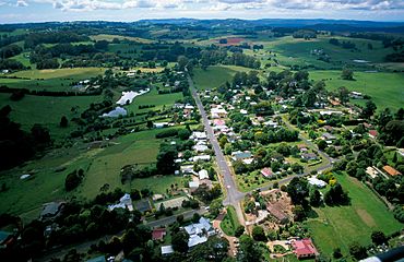
Aerial photo
|
|||||||||||||||
| Postcode(s) | 2577 | ||||||||||||||
| Elevation | 760 m (2,493 ft) | ||||||||||||||
| Location | |||||||||||||||
| LGA(s) | Wingecarribee Shire | ||||||||||||||
| County | Camden | ||||||||||||||
| Parish | Yarrunga | ||||||||||||||
| State electorate(s) | Goulburn | ||||||||||||||
| Federal Division(s) | Whitlam | ||||||||||||||
|
|||||||||||||||
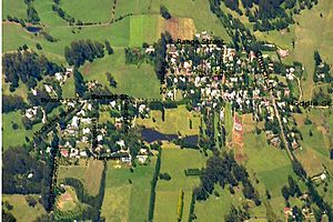
Burrawang (/ˈbʌrəwæŋ/ burr-Ə-wang) is a small village. It is located in the beautiful Southern Highlands area of New South Wales, Australia. Burrawang is part of the Wingecarribee Shire.
The village sits high on a hill, about 760 meters (2,493 feet) above sea level. It is found right between two large water reservoirs. These are the Wingecarribee and the Fitzroy reservoirs.
History of Burrawang
Long ago, before European settlers arrived, the Wadi Wadi tribe lived in the Burrawang area. They were Aboriginal people.
In 1802, a British naval doctor named Charles Throsby came to Australia. He became an important settler. In 1819, Throsby became the first landowner in the Southern Highlands. He started a cattle farm. Today, his old farm, Throsby Park, is a museum you can visit.
In 1830, a surveyor named Robert Hoddle and some convicts built a path. This path helped connect different towns. People soon noticed the rich soil and beautiful rainforest in the Yarrawa Brush region.
The first land was officially given out in 1859. This was in what is now Wildes Meadow. In 1865, Burrawang got its first post office. The village was named after a native palm tree that grew a lot there. Soon after, the first school opened. Later, in 1876, a public school replaced it.
Around this time, three churches were built on Church Street. These included a Catholic church in 1875, an Anglican church in 1886, and a Presbyterian church in 1888.
Burrawang was a busy place. Its main industries were dairy farming and growing potatoes and vegetables. There were also mills for flour and timber. The village even had its own newspaper, called the Burrawang Herald. The local hall hosted many social events, including an annual ball.
For many years, Burrawang was the main town in the Yarrawa Brush area. However, in the late 1880s, Robertson started to grow more. A new, more direct road to Moss Vale helped Robertson become the key settlement. After Macquarie Pass opened in 1898, Burrawang became a bit more isolated.
Who Lives in Burrawang?
The number of people living in Burrawang has changed over time.
- In the 2016 census, there were 361 people living in Burrawang. Most people (80.1%) were born in Australia. Also, 88.1% of people spoke only English at home. The most common answer for religion was "No Religion" (31.1%).
- According to the 2021 census, the population grew to 431 people living in Burrawang.
The Legend of the Burrawang Bunyip
There is a swamp just outside Burrawang. People say it is home to a legendary creature called the Burrawang Bunyip. This mysterious animal is rumored to roam around at night. Some stories say it kills cattle. If anyone tries to catch the bunyip, it is said to simply disappear!
 | Audre Lorde |
 | John Berry Meachum |
 | Ferdinand Lee Barnett |


