Moss Vale facts for kids
Quick facts for kids Moss ValeNew South Wales |
|||||||||||||||
|---|---|---|---|---|---|---|---|---|---|---|---|---|---|---|---|

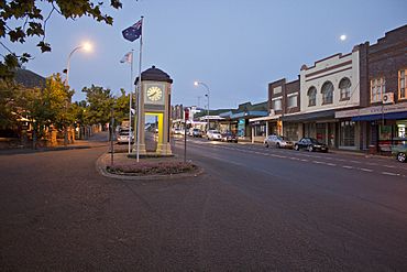
Argyle Street, which forms part of the Illawarra Highway
|
|||||||||||||||
| Established | 1861 | ||||||||||||||
| Postcode(s) | 2577 | ||||||||||||||
| Elevation | 678 m (2,224 ft) | ||||||||||||||
| Location |
|
||||||||||||||
| LGA(s) | Wingecarribee Shire | ||||||||||||||
| Region | Southern Highlands | ||||||||||||||
| County | Camden | ||||||||||||||
| Parish | Bong Bong | ||||||||||||||
| State electorate(s) | Goulburn | ||||||||||||||
| Federal Division(s) | Whitlam | ||||||||||||||
|
|||||||||||||||
|
|||||||||||||||
Moss Vale is a lovely town in the Southern Highlands of New South Wales, Australia. It's part of the Wingecarribee Shire. The town is located on the Illawarra Highway. This highway connects Moss Vale to Wollongong and the Illawarra coast through Macquarie Pass.
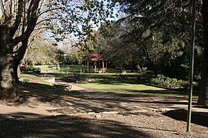
Moss Vale has many old and important buildings. In the middle of the main street, you'll find Leighton Gardens. Recently, around 2019, Moss Vale became more modern and stylish. It is now a popular spot for unique shops, cafes, and bars. The town also has a business area and a golf course. You can also visit a large parkland called Cecil Hoskins Nature Reserve.
Contents
History of Moss Vale
The land around Moss Vale once belonged to the Gandangara people. Sadly, they were gone by the 1870s. This was partly because European settlers took over their hunting grounds.
In 1798, Governor Hunter sent a group to explore the area. It was led by John Wilson, a former convict. Other explorers visited the area until 1815. These included John Warby, George Caley, Hamilton Hume, and John Oxley.
In 1817, Hume, Charles Throsby, and Joseph Wild explored west of Sutton Forest. In 1818, they explored the area between Moss Vale and Jervis Bay with James Meehan.
Governor Macquarie gave Throsby 1,000 acres (4.0 km2) of land. This land was known as Throsby Park. It was located at Bong Bong, just outside Moss Vale. In 1819, Throsby was put in charge of building the Old Argyle Road. This road went from Sydney to Goulburn.
In the 1830s, a new, more direct road was built. This road went through Berrima. Most people from Bong Bong then moved to Berrima. The historic Throsby Park house was built around 1834. This was six years after Throsby had passed away.
The area was considered part of Sutton Forest for a long time. It stayed a farming area until the railway arrived. In 1864, land from Throsby Park was divided to create the town of Moss Vale. The town was named after Jemmy Moss, who was a herdsman at Throsby Park. This happened before the Sutton Forest railway station opened in 1867. The station was at the crossing with Old Argyle Road.
Governor Belmore rented Throsby Park from 1870 to 1872. People believe he did this to escape Sydney's summer heat. The railway and new land laws helped more people settle in the Southern Highlands. This led to Moss Vale growing into a town. In 1877, Sutton Forest railway station was renamed Moss Vale.
Weather in Moss Vale
Moss Vale has an oceanic climate. This means it has warm to mild, rainy summers. Its winters are cool and sunny.
| Climate data for Moss Vale AWS (2001–2022); 678 m AMSL; 34.53° S, 150.42° E | |||||||||||||
|---|---|---|---|---|---|---|---|---|---|---|---|---|---|
| Month | Jan | Feb | Mar | Apr | May | Jun | Jul | Aug | Sep | Oct | Nov | Dec | Year |
| Record high °C (°F) | 40.9 (105.6) |
41.2 (106.2) |
34.0 (93.2) |
30.7 (87.3) |
23.4 (74.1) |
20.3 (68.5) |
21.4 (70.5) |
22.5 (72.5) |
30.4 (86.7) |
31.7 (89.1) |
37.9 (100.2) |
41.1 (106.0) |
41.2 (106.2) |
| Mean daily maximum °C (°F) | 26.2 (79.2) |
24.4 (75.9) |
21.8 (71.2) |
19.2 (66.6) |
15.5 (59.9) |
12.5 (54.5) |
11.9 (53.4) |
13.4 (56.1) |
16.7 (62.1) |
19.5 (67.1) |
22.0 (71.6) |
24.1 (75.4) |
18.9 (66.1) |
| Mean daily minimum °C (°F) | 14.2 (57.6) |
14.0 (57.2) |
12.1 (53.8) |
8.7 (47.7) |
4.9 (40.8) |
3.4 (38.1) |
2.5 (36.5) |
3.0 (37.4) |
5.4 (41.7) |
7.9 (46.2) |
10.5 (50.9) |
12.2 (54.0) |
8.2 (46.8) |
| Record low °C (°F) | 4.1 (39.4) |
5.7 (42.3) |
2.2 (36.0) |
−2.5 (27.5) |
−3.4 (25.9) |
−6.3 (20.7) |
−5.6 (21.9) |
−5.4 (22.3) |
−4.0 (24.8) |
−2.0 (28.4) |
−0.1 (31.8) |
2.0 (35.6) |
−6.3 (20.7) |
| Average precipitation mm (inches) | 65.0 (2.56) |
101.4 (3.99) |
96.6 (3.80) |
55.9 (2.20) |
48.3 (1.90) |
76.5 (3.01) |
63.7 (2.51) |
54.7 (2.15) |
41.9 (1.65) |
52.8 (2.08) |
72.3 (2.85) |
60.1 (2.37) |
784.5 (30.89) |
| Average precipitation days | 13.2 | 14.2 | 16.6 | 15.7 | 15.0 | 16.8 | 13.8 | 12.3 | 11.5 | 12.1 | 14.2 | 12.5 | 167.9 |
| Average afternoon relative humidity (%) | 51 | 60 | 59 | 58 | 60 | 63 | 61 | 53 | 51 | 51 | 56 | 52 | 56 |
Important Historic Places
Moss Vale has several places listed for their historical importance:
- Church Road: Throsby Park
- Main Southern railway: Moss Vale railway station
- Main Southern railway 146.037: Argyle Street railway bridge
- Oldbury Road: Oldbury Farm
Population Facts
In 2021, a census showed that 9,310 people lived in Moss Vale.
The 2016 census found 8,579 people in Moss Vale.
- About 2.6% of the people were Aboriginal and Torres Strait Islander.
- 78.2% of people were born in Australia.
- Other common birthplaces were England (4.4%), New Zealand (1.7%), and China (1.5%).
- 87.2% of people spoke only English at home.
- Mandarin was spoken by 1.3% of people at home.
- The most common religions were No Religion (25.8%), Anglican (24.9%), and Catholic (22.1%).
Economy and Jobs
Moss Vale is a big part of the Southern Highlands' industry. It is also a smaller center for farming. Many light and medium industries are found in and around Moss Vale. These include a James Hardie factory and a HarperCollins book distribution center. Other manufacturing businesses are also located here. Even though Moss Vale is important for industry, nearby Bowral is the main business center of the Southern Highlands.
Moss Vale is known for its rich soil and good rainfall. Farms in the area mostly raise dairy cows, especially Holstein Friesian cattle. There are also farms that raise beef cattle and sheep.
Local Government and Safety
The Wingecarribee Shire Council Chambers are at 68 Elizabeth Street, Moss Vale. You can find them online:
- Wingecarribee Shire Council Website
- Wingecarribee Shire Council Facebook Page
The Southern Highlands Police Station serves the area. It is part of the Hume Police District. This is the main NSW Police Force station for the Southern Highlands. It is located at 67 Elizabeth Street.
Moss Vale also has a New South Wales Rural Fire Service Brigade. It is located at 49 Berrima Road. There is also a Fire and Rescue NSW Station at 64 Elizabeth Street, Moss Vale. This station is across the road from the Police Station. It is also just up the street from the Wingecarribee Shire Council Chambers.
Getting Around
Moss Vale station is the main southern end of the Southern Highlands railway line. This line offers regular train services from Moss Vale to southern Sydney. Usually, you need to change trains to get to the city center. Some services continue south of Moss Vale to Goulburn. The station also has two Sydney to Melbourne trains each day. It also has two Melbourne to Sydney trains daily. Moss Vale is where the Unanderra – Moss Vale railway line connects. This line goes to Wollongong. It opened in 1932 but is now only used by freight trains.
Television Services
Television signals for Moss Vale come from the Illawarra region. The main transmitter is on Mount Gibraltar.
Here are the Southern NSW Channels available:
- ABC (includes ABC News, ABC Comedy, ABC Me, ABC Kids)
- SBS (includes SBS Viceland, Food Network, NITV)
- 7 Moss Vale (includes 7TWO, 7mate, 7flix, Racing.com & ishoptv) – This is an affiliate of the Prime Television-Seven Network.
- WIN Television (includes ELEVEN, ONE, TVSN & Aspire TV, Gold & Gold 2) – This is an affiliate of the Ten Network.
- 9Capital (includes 9Go!, 9Gem, 9Life, SBN & Aspire) – This is an affiliate of the Southern Cross Television-Nine Network.
Schools in Moss Vale
- Moss Vale High School
- Moss Vale Public School
- St Paul's Catholic Primary School
- St Paul's International College
- Tudor House School
Churches in Moss Vale
- Connect Christian Church (AOG/ACC)
- Moss Vale Jehovah's Witnesses Hall
- Moss Vale Uniting Church in Australia
- St Andrews Presbyterian Church
- St John's Anglican Church
- St Paul's Roman Catholic Church
Sports Teams
Here are some of the sporting teams in Moss Vale:
- Moss Vale Basketball
- Moss Vale Cricket Club
- Moss Vale Dragonflies Netball Club
- Moss Vale Dragons Rugby League Club
- Moss Vale Golf Club
- Moss Vale Hockey Club
- Moss Vale Rifle Club
- Moss Vale Soccer Club (part of the Highlands Soccer Association)
Famous People from Moss Vale
- Ann Carr-Boyd, a composer and music expert.
- Tom Green, an artist.
- Tony Lockett, a former AFL player for the Sydney Swans.
- Steve Prestwich, the drummer for the popular Australian rock band, Cold Chisel.
- Ray Stone, a rugby league player.
Former Famous Residents
- Dr Frank Tidswell, a microbiologist, and his wife Edith lived at Farnborough in the 1930s.
 | Claudette Colvin |
 | Myrlie Evers-Williams |
 | Alberta Odell Jones |


