
Jervis Bay facts for kids
Quick facts for kids Jervis Bay |
|
|---|---|
 |
|

Jervis Bay
Location in New South Wales
|
|

Jervis Bay from orbit
|
|
| Location | Jervis Bay Territory; New South Wales |
| Coordinates | 35°03′55″S 150°44′05″E / 35.06528°S 150.73472°E |
| Type | Oceanic bay |
| Primary outflows | Tasman Sea |
| Basin countries | Australia |
Jervis Bay is a beautiful bay on the south coast of New South Wales, Australia. It covers about 102-square-kilometre (39 sq mi) and is famous for having some of the whitest sand in the world! You can find villages like Jervis Bay Village and Wreck Bay Village around its shores.
A special area of land, about 70-square-kilometre (27 sq mi), around the southern part of the bay is called the Jervis Bay Territory. This land belongs to the Commonwealth of Australia. The Royal Australian Navy (RAN) has a base there called HMAS Creswell, located between Jervis Bay Village and Greenpatch Point.
Contents
History of Jervis Bay
Ancient Times and Early Explorers
Long, long ago, Aboriginal people lived around Jervis Bay. We know this from old tools and campsites found at Burrill Lake, not far from the bay. These findings show people were here as far back as 20,000 years ago!
The first European to see Jervis Bay was Lieutenant James Cook. He sailed past on 25 April 1770 in his ship, HMS Endeavour. He named the southern tip of the bay Cape St George.
Later, in August 1791, another navy officer, Lieutenant Richard Bowen, sailed into the bay. He was on a ship called Atlantic. He named the bay after Admiral John Jervis, who was his commander. A few months later, in November 1791, a ship called Matilda also came into the bay for repairs.
Settlement and Changes
In 1797, some people who survived a shipwreck passed through the area. They were trying to walk all the way to Port Jackson (Sydney). Only three of them made it!
Explorer George Bass visited the bay on 10 December 1797. He named Bowen Island, which is still there today.
In the 1800s, European settlers started taking over land. This meant that Aboriginal people, like the Wandandian people, were moved from their traditional homes. Some were moved to Wreck Bay. However, a group of Wandandian people, known as 'the Jervis Bay tribe', stayed on their lands near Huskisson and St Georges Basin for many years.
A town called South Huskisson was started in 1841. It was a seaport and a key point for transporting wool. In 1952, this town was renamed Vincentia.
Jervis Bay Territory and Modern Plans
In 1915, the land that is now the Jervis Bay Territory was given to the Australian Government. This was done to give the new capital city, Canberra, a seaport. Canberra is Australia's only capital city that is not on the coast.
In the 1960s, there was a plan to build Australia's first nuclear power plant in Jervis Bay. A site was even prepared, but the project was never finished.
Geography of Jervis Bay
How Jervis Bay Was Formed
Jervis Bay is a "drowned river valley." This means it was once a river valley that got filled with water as sea levels rose. This happened about 15,000 years ago, after the last ice age. The bay looks like it does today because the sea level rose by about 120 metres (390 ft). Sand dunes also helped create the southern part of the bay.
Most of the rocks in Jervis Bay are sandstone, which is very old, about 280-225 million years old. Scientists have also found signs that huge tsunamis hit the Australian coast before Europeans arrived, and some of these signs are in Jervis Bay.
Places Around the Bay
On the southern side of Jervis Bay, in the Jervis Bay Territory, you'll find small towns like Greenpatch, Hyams Beach, and Bowen Island.
On the New South Wales side of the bay, from north to south, are Callala Beach, Callala Bay, Huskisson, and Vincentia.
The Beecroft Peninsula is on the northern side of the bay. Point Perpendicular is at the southern end of this peninsula. Jervis Bay is about a three-hour drive south of Sydney.
Nature and Protected Areas
Jervis Bay is home to many important natural areas that are protected. These include Booderee National Park, Jervis Bay National Park, and the Jervis Bay Marine Park. These parks help protect the plants and animals that live here.
The area around Jervis Bay is also very important for birds. BirdLife International has named it an Important Bird Area (IBA). This is because the coastal heathland here is home to the largest group of the endangered eastern bristlebird.
As mentioned, Jervis Bay is famous for having the whitest sand in the world!

Fun Things to Do

Jervis Bay is a great place for outdoor activities! You can go recreational fishing, kayaking, paddleboarding, sailing, and scuba diving. Many tour operators in Huskisson can take you out on the water. If you have your own boat, there are ramps in the towns and at campsites.
Some popular spots for diving include The Labyrinths, Gorgonian Wall, Point Perpendicular, and even a submerged old aeroplane!
Whale Watching
Jervis Bay is also a fantastic place for whale watching. Many whales swim past the bay as they migrate north and south. They often come into the calm waters of the bay to rest.
Most of the whales you'll see are humpbacks. They travel along Australia's east coast from June to November. You might also spot southern right whales, whose numbers are slowly growing after being hunted a lot in the past. Sometimes, other types of whales like false killer whales, orcas, minke whales, and even a blue whale have been seen here!
Tourism in Jervis Bay
Tourism is very important for the people living around Jervis Bay. Many local businesses focus on visitors. You can find helpful information at the Jervis Bay Visitors Information Centre in Huskisson. There are also visitor centres in Nowra and Ulladulla.
Farming in the Sea (Aquaculture)
In 2015, the first commercial licence for farming seafood in the bay was given out. This business started growing blue mussels. They also found lots of Angasi oysters and scallops growing naturally. The main focus is on blue mussels because they have a lot of meat inside their shells.
There are also plans to grow seaweed for commercial use. The local council is investing A$2.3 million to build a wharf and other facilities to help this industry grow. It is hoped that this new industry could create up to 1,000 jobs!
Climate of Jervis Bay
Jervis Bay has an oceanic climate, which means it has mild weather. In winter, the average high temperature is around 16°C, and in summer, it's about 25°C. Sea breezes help keep it from getting too hot. The hottest temperature ever recorded was 42.1°C in January, and the coldest was 4.7°C in August.
On hot summer evenings, a cool wind often blows in, which is called a southerly buster. This helps to cool things down quickly.
Rainfall is spread out fairly evenly throughout the year, but there's a bit more rain in the first half of the year. Sometimes, there are short, heavy rainfalls that can cause local flooding. Thunderstorms with lightning, heavy rain, and sometimes hail can happen during the warmer months.
The amount of rain each year can be affected by a natural weather pattern called the El Niño-Southern Oscillation.
| Month | Jan | Feb | Mar | Apr | May | Jun | Jul | Aug | Sep | Oct | Nov | Dec | Year |
|---|---|---|---|---|---|---|---|---|---|---|---|---|---|
| Record high °C (°F) | 42.1 (107.8) |
38.3 (100.9) |
34.7 (94.5) |
30.2 (86.4) |
26.1 (79.0) |
22.9 (73.2) |
24.0 (75.2) |
25.6 (78.1) |
31.2 (88.2) |
35.7 (96.3) |
38.2 (100.8) |
34.1 (93.4) |
42.1 (107.8) |
| Mean daily maximum °C (°F) | 24.9 (76.8) |
24.3 (75.7) |
23.4 (74.1) |
21.1 (70.0) |
18.6 (65.5) |
16.6 (61.9) |
15.8 (60.4) |
17.0 (62.6) |
19.3 (66.7) |
21.1 (70.0) |
22.3 (72.1) |
23.3 (73.9) |
20.6 (69.1) |
| Mean daily minimum °C (°F) | 18.3 (64.9) |
18.5 (65.3) |
17.4 (63.3) |
15.3 (59.5) |
12.6 (54.7) |
11.0 (51.8) |
9.8 (49.6) |
10.2 (50.4) |
12.0 (53.6) |
13.5 (56.3) |
15.4 (59.7) |
16.7 (62.1) |
14.2 (57.6) |
| Record low °C (°F) | 13.1 (55.6) |
12.6 (54.7) |
12.5 (54.5) |
9.1 (48.4) |
8.2 (46.8) |
5.8 (42.4) |
5.1 (41.2) |
4.7 (40.5) |
6.1 (43.0) |
7.7 (45.9) |
9.0 (48.2) |
10.5 (50.9) |
4.7 (40.5) |
| Average rainfall mm (inches) | 95.5 (3.76) |
136.9 (5.39) |
107.9 (4.25) |
132.4 (5.21) |
120.0 (4.72) |
156.7 (6.17) |
116.5 (4.59) |
68.1 (2.68) |
59.1 (2.33) |
78.7 (3.10) |
82.3 (3.24) |
77.7 (3.06) |
1,234.2 (48.59) |
| Average rainy days | 11.3 | 13.3 | 12.6 | 14.1 | 10.4 | 12.1 | 10.9 | 8.8 | 9.5 | 11.3 | 12.6 | 12.6 | 139.5 |
| Source: Bureau of Meteorology | |||||||||||||
Images for kids
-
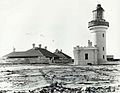
The Point Perpendicular Lighthouse in 1899
-
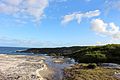
Cliff faces and plants at the Booderee National Park
-
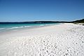
Hyams Beach, a white sandy beach
-
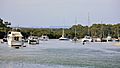
Recreational boats at Huskisson


.jpg)
See also
 In Spanish: Bahía de Jervis para niños
