Ulladulla, New South Wales facts for kids
Quick facts for kids UlladullaNew South Wales |
|||||||||||||||
|---|---|---|---|---|---|---|---|---|---|---|---|---|---|---|---|

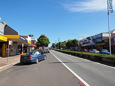
Ulladulla town centre
|
|||||||||||||||
| Population | 17,026 (2021) | ||||||||||||||
| Postcode(s) | 2539 | ||||||||||||||
| Elevation | 15 m (49 ft) | ||||||||||||||
| Location |
|
||||||||||||||
| LGA(s) | City of Shoalhaven | ||||||||||||||
| Region | South Coast | ||||||||||||||
| County | St Vincent | ||||||||||||||
| Parish | Ulladulla | ||||||||||||||
| State electorate(s) | South Coast | ||||||||||||||
| Federal Division(s) | Gilmore | ||||||||||||||
|
|||||||||||||||
|
|||||||||||||||
Ulladulla is a coastal town in New South Wales, Australia. It is part of the City of Shoalhaven area. You can find it on the Princes Highway, about 230 kilometres south of Sydney. It's roughly halfway between Batemans Bay and Nowra. Ulladulla works closely with the nearby town of Milton, and they often share services.
Contents
History of Ulladulla
The name Ulladulla comes from an Aboriginal word. Its exact meaning is not fully known. Some old records say it means "safe harbour," but local Aboriginal Elders disagree. They explain that a harbour for boats is a modern idea. The name was once mistakenly called "Holy Dollar." Other old spellings include Woolladoorh or Ngulla-dulla.
The first European to settle here was Reverend Thomas Kendall in 1828. He started cutting Australian red cedar wood. This happened near Yackungarrah and Narrawallee Creek in Yatte Yattah, which is about 4 kilometres north of where Milton is today.
People in Ulladulla
Let's look at who lives in Ulladulla.
Population Numbers
At the 2021 census, 17,026 people lived in Ulladulla.
- About 4.1% of the people were Aboriginal and Torres Strait Islander.
- Most people, 80.9%, were born in Australia.
- Other common birthplaces included England (4.3%), New Zealand (1.4%), and Scotland (0.6%).
- Most people (90.3%) spoke only English at home.
- The most common religions were No Religion (41.5%), Catholic (19.7%), and Anglican (17.6%).
| Historical population | ||
|---|---|---|
| Year | Pop. | ±% |
| 1921 | 1,357 | — |
| 1933 | 1,415 | +4.3% |
| 1947 | 1,844 | +30.3% |
| 1954 | 1,210 | −34.4% |
| 1961 | 1,458 | +20.5% |
| 1966 | 1,661 | +13.9% |
| 1971 | 2,781 | +67.4% |
| 1976 | 4,271 | +53.6% |
| 1981 | 6,018 | +40.9% |
| 1986 | 7,408 | +23.1% |
| 1991 | 7,381 | −0.4% |
| 1996 | 8,384 | +13.6% |
| 2001 | 9,585 | +14.3% |
| 2006 | 10,298 | +7.4% |
| 2011 | 12,137 | +17.9% |
| 2016 | 13,054 | +7.6% |
| 2021 | 14,396 | +10.3% |
| Source: Australian Bureau of Statistics data. | ||
Geography and Nature
The Ulladulla area is a long stretch of towns and homes, about seven kilometres long. It goes from the south side of Ulladulla, through Mollymook, and up to Narrawallee in the north. This whole area ends at the Narrawallee estuary, which is where a river meets the sea.
Nearby Towns and Landmarks
Ulladulla is surrounded by other towns like Milton, Burrill Lake, Mollymook, and Narrawallee. The larger area from Burrill Lake to Milton is often called the Milton–Ulladulla area.
Close by, you can find Pigeon House Mountain and "The Castle." These mountains are named for their unique shapes. Captain James Cook saw Pigeon House Mountain when he sailed along Australia's eastern coast. Recently, Pigeon House Mountain was renamed "Didhol." This was done to respect the elders of the Yuin nation, who are the Aboriginal people from this area. The traditional name, Didhol, means "woman's breast" because of the mountain's shape.
Climate in Ulladulla
Ulladulla has a mild oceanic climate, just like the rest of the NSW South Coast. This means it has warm summers and cool winters. The warm waters of the nearby Tasman Sea help keep the weather mild. This means there are no extreme hot or cold temperatures. Weather information for Ulladulla has been collected since 1989.
| Climate data for Ulladulla | |||||||||||||
|---|---|---|---|---|---|---|---|---|---|---|---|---|---|
| Month | Jan | Feb | Mar | Apr | May | Jun | Jul | Aug | Sep | Oct | Nov | Dec | Year |
| Record high °C (°F) | 44.5 (112.1) |
42.4 (108.3) |
35.6 (96.1) |
34.5 (94.1) |
27.2 (81.0) |
23.5 (74.3) |
23.9 (75.0) |
27.9 (82.2) |
31.2 (88.2) |
36.1 (97.0) |
40.0 (104.0) |
38.7 (101.7) |
44.5 (112.1) |
| Mean daily maximum °C (°F) | 24.1 (75.4) |
24.2 (75.6) |
23.3 (73.9) |
21.4 (70.5) |
19.0 (66.2) |
16.9 (62.4) |
16.3 (61.3) |
17.4 (63.3) |
19.2 (66.6) |
20.6 (69.1) |
21.5 (70.7) |
22.9 (73.2) |
20.6 (69.1) |
| Mean daily minimum °C (°F) | 17.2 (63.0) |
17.6 (63.7) |
16.3 (61.3) |
13.9 (57.0) |
11.7 (53.1) |
9.8 (49.6) |
8.9 (48.0) |
9.2 (48.6) |
10.8 (51.4) |
12.2 (54.0) |
14.0 (57.2) |
15.7 (60.3) |
13.1 (55.6) |
| Record low °C (°F) | 10.5 (50.9) |
10.3 (50.5) |
10.0 (50.0) |
8.1 (46.6) |
5.9 (42.6) |
3.3 (37.9) |
2.5 (36.5) |
4.0 (39.2) |
3.7 (38.7) |
4.8 (40.6) |
6.3 (43.3) |
7.9 (46.2) |
2.5 (36.5) |
| Average precipitation mm (inches) | 80.3 (3.16) |
116.6 (4.59) |
107.9 (4.25) |
102.1 (4.02) |
104.1 (4.10) |
115.8 (4.56) |
69.3 (2.73) |
59.8 (2.35) |
75.8 (2.98) |
80.1 (3.15) |
87.7 (3.45) |
63.9 (2.52) |
1,062.4 (41.83) |
| Average precipitation days | 12.6 | 13.3 | 12.6 | 11.5 | 9.8 | 10.3 | 8.6 | 7.4 | 9.8 | 10.7 | 14.1 | 12.0 | 132.7 |
| Average relative humidity (%) | 71 | 73 | 70 | 67 | 64 | 62 | 59 | 56 | 60 | 63 | 67 | 71 | 65 |
Ulladulla Harbour
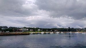
Ulladulla Harbour is a small port managed by the Land and Property Management Authority.
In 1859, a wooden jetty was built. This was important because a shipping company said they would stop coming to Ulladulla if there weren't better places to dock boats. Seven years later, the government replaced the wooden jetty with a stone pier. The shipping company also built a store by the harbour to handle goods being shipped to and from Sydney. There was a weekly shipping service to Ulladulla until the mid-1950s.
In 1873, a lighthouse was built on the harbour's breakwater. It was first called the Ulladulla Lighthouse. In 1889, it was moved to Warden Head, which is south of the harbour. It is still working there today.
Around the 1890s, a special track for a tramway was built to the end of the stone wharf. People and horses were used to move wagons along this track. By 1910-1911, a double track was laid. Records show the track was used and maintained until at least 1947-1948. Most of the track was gone by 1991.
Today, the harbour is home to the biggest commercial fishing fleet on the South Coast of New South Wales. This means many fishing boats use Ulladulla as their main port.
Blessing of the Fleet Festival
The Blessing of the Fleet festival is a special event held regularly at Easter since 1956. This tradition started centuries ago in Sicily, Italy. It is continued by the families of the original Italian immigrants who came to the area to fish.
A very important part of the festival is the religious Blessing of the Fleet ceremony. This happens at Ulladulla Harbour on Easter Sunday. The celebrations end with a fireworks display over the harbour on Easter Sunday. There are also Harbour Markets on Easter Monday.
The big celebration was cancelled in 2004 and 2005 because of high insurance costs. But it came back in 2008. It was cancelled again in 2020 and 2021 due to the COVID-19 pandemic. In 2022, it returned but with some safety rules because of COVID.
Getting Around Ulladulla
You can get around Ulladulla using public transport.
- Premier Motor Service runs two bus services each day. These go in both directions between Sydney and Eden. They also have two services from Bomaderry railway station that connect with NSW TrainLink trains.
- Ulladulla Buslines provides local bus services on weekdays. There is a smaller service on Saturdays. Three bus routes start from Ulladulla. Routes 740 and 740V go from Burrill Lake to Milton. They pass through Kings Point, Ulladulla, Mollymook, and Narrawallee. Route 741 runs less often, only on weekdays. It goes from Ulladulla to Kiola, passing through Burrill Lake, Tabourie Lake, Termeil, and Bawley Point.
- Taxis and private hire cars are also available to help you travel around the area.
Shopping and Businesses
Ulladulla has many shops and businesses. Most of them are along the Princes Highway and in nearby streets.
- Ulladulla Shopping Centre has a Woolworths supermarket and eight smaller shops.
- Dolphin Court has a Coles supermarket and seven smaller shops. Next to it is The Reject Shop.
- You can also find an Aldi supermarket, Bunnings, Mitre 10, Best & Less, Harris Scarfe, and a K Hub store. The K Hub store used to be a Target Country store, but it closed in February 2021.
- Ulladulla has several shopping arcades on Princes Highway. Rowen's Arcade has a cinema, a Funland arcade, and 23 smaller shops. Other arcades include Eastside Mall, Plaza, Riviera Arcade, Phillip Centre, and Bellbrook Arcade.
Education in Ulladulla
Ulladulla has schools for different age groups.
- Ulladulla Public School opened in August 1861.
- Ulladulla High School opened in January 1974.
Famous People from Ulladulla
Some notable people were born in Ulladulla:
- Winter Warden (1860–1936) was a parliamentarian.
- Alexander Shand (1865–1949) was a barrister and King's Counsel. He was also a Royal Commissioner.
- Colonel Alfred Warden (1868–1955) was a soldier, military engineer, and architect.
Local News
Since 1878, Ulladulla has had a weekly newspaper called the Milton Ulladulla Times.
Political Representation
Ulladulla is part of the federal division of Gilmore. This area is represented by Labor MP Fiona Phillips. For state government, Ulladulla is in the South Coast seat.
Images for kids
 | DeHart Hubbard |
 | Wilma Rudolph |
 | Jesse Owens |
 | Jackie Joyner-Kersee |
 | Major Taylor |


