
Narrawallee facts for kids
Quick facts for kids NarrawalleeNew South Wales |
|||||||||||||||
|---|---|---|---|---|---|---|---|---|---|---|---|---|---|---|---|

Narrawallee beach
|
|||||||||||||||

Narrawallee
Location in New South Wales
|
|||||||||||||||
| Population | 1,241 (2016 census) | ||||||||||||||
| Postcode(s) | 2539 | ||||||||||||||
| Elevation | 22 m (72 ft) | ||||||||||||||
| Location | |||||||||||||||
| LGA(s) | City of Shoalhaven | ||||||||||||||
| Region | South Coast | ||||||||||||||
| County | St Vincent | ||||||||||||||
| Parish | Conjola | ||||||||||||||
| State electorate(s) | South Coast | ||||||||||||||
| Federal Division(s) | Gilmore | ||||||||||||||
|
|||||||||||||||
Narrawallee (pronounced NARRA-wol-lee) is a small coastal village. It is located on the South Coast of New South Wales, Australia. In 2016, about 1,241 people lived there.
Narrawallee is often seen as part of the larger Milton-Ulladulla area. This area is within the City of Shoalhaven. The village is mostly made up of homes. It is next to a tidal inlet (a small arm of the sea) to the north. The name "Narrawallee" comes from a local creek. This creek flows from Milton to the Tasman Sea. The name is believed to come from Aboriginal words like Nurrawerree or Narra Warra.
Narrawallee's History
The first people to live in the Narrawallee area were the Budawang tribe. They are part of the Yuin nation. These Aboriginal people were the traditional landowners.
Europeans started activities in Narrawallee in 1924. A special railway, called a tramway, was built. It was 610 mm wide. This tramway moved silica from nearby Conjola. Silica is a type of sand used to make glass and other things. It was taken to a jetty at Bannister Head.
Building this tramway needed a bridge. The bridge crossed the Narrawallee inlet. It was made from local wood and cost £2600. The silica was crushed at Bannister Head. Then, it was shipped to steel factories. These factories were in Newcastle and Port Kembla.
The tramline was used until World War II. Production slowed down during the war. So, the rails were removed in 1943. The bridge was taken apart the next year. You can still see parts of the old bridge supports today. They are on the northern side of the Narrawallee inlet.
Narrawallee Today
Narrawallee is a popular place because it is on the coast. New homes and buildings started to appear in the 1960s and 1970s. Today, it has homes where people live all the time. There are also holiday rentals and "weekenders." These are homes people use for short holidays.
The houses are built a bit away from Narrawallee Beach. This creates a public area near the beach. It is called a foreshore reserve. During summer holidays, lifeguards help keep people safe. They are from the Mollymook Surf Lifesaving Club. They patrol the southern part of the beach.
There is a boat ramp at Narrawallee Inlet. Small boats can be launched here. This depends on the tides. The area also has public restrooms, picnic spots, and barbecue areas. The reserve is great for many activities. You can go bushwalking or fishing. Water sports are also popular. Families especially like the estuary. It is protected from rough ocean waves.
Local bus services serve the village six days a week. Ulladulla Bus Lines route 740 goes to Milton and Ulladulla. The Milton-Ulladulla Baptist Church is also located in Narrawallee.
Images for kids
-
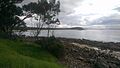
Narrawallee beach viewed from Bannister Headland

