Termeil facts for kids
Quick facts for kids TermeilNew South Wales |
|||||||||||||||
|---|---|---|---|---|---|---|---|---|---|---|---|---|---|---|---|

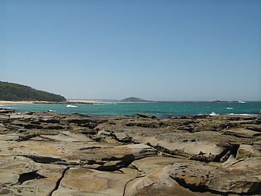
Looking north from Termeil Point towards Lake Tabourie
|
|||||||||||||||
| Postcode(s) | 2539 | ||||||||||||||
| LGA(s) | City of Shoalhaven | ||||||||||||||
| Region | South Coast | ||||||||||||||
| County | St Vincent | ||||||||||||||
| Parish | Termeil | ||||||||||||||
| State electorate(s) | South Coast | ||||||||||||||
| Federal Division(s) | Gilmore | ||||||||||||||
|
|||||||||||||||
Termeil is a small village located in the Shoalhaven area of New South Wales, Australia. It is a quiet, mostly rural place. The village sits at an important crossroads. From here, you can reach the beach towns of Bawley Point and Kioloa. It also connects to the main Princes Highway. A local bus, Ulladulla Bus Lines route 741, serves Termeil twice on weekdays.
About Termeil Village
Termeil is known for its peaceful, country setting. It acts as a gateway to beautiful coastal areas. Many people pass through Termeil on their way to the beaches. The village is surrounded by natural bushland.
Getting Around Termeil
The main roads in Termeil help people travel easily. Bawley Point Road leads to popular beach communities. The Princes Highway is a major route connecting many towns. Local buses offer a way for residents to get around. This makes it easier to reach nearby towns and services.
Termeil's School History
Termeil once had its own public school. It first opened in 1885. The school taught local children for many years. It closed for a short time in 1941. The school then reopened in 1943. It continued to operate until 1955. Sometimes it was called a "provisional" school. This meant it was set up to serve a smaller number of students.
 | Victor J. Glover |
 | Yvonne Cagle |
 | Jeanette Epps |
 | Bernard A. Harris Jr. |


