
Booderee National Park and Botanic Gardens facts for kids
Quick facts for kids Booderee National ParkJervis Bay Territory |
|
|---|---|
|
IUCN Category II (National Park)
|
|

Booderee National Park
Location in Jervis Bay Territory
|
|
| Nearest town or city | Sussex Inlet |
| Established | 1992 |
| Area | 63.12 km2 (24.4 sq mi) |
| Managing authorities | Director of National Parks Wreck Bay Aboriginal community |
| Website | Booderee National Park |
Booderee National Park and Botanic Gardens is a special place in the Jervis Bay Territory of Australia. It used to be called Jervis Bay National Park. The park is made up of two main areas:
- The Bherwerre Peninsula, which is on the southern side of Jervis Bay, including Bowen Island and the waters south of the bay.
- Lands bordered by Wreck Bay to the south, St Georges Basin to the north, and Sussex Inlet to the west.
This area was first protected as a nature reserve in 1971. In 1992, it became the Jervis Bay National Park. In 1995, the park was officially given to the Wreck Bay Aboriginal Community. At this time, its name changed to "Booderee." This name means "bay of plenty" or "plenty of fish" in the local Dhurga language. Today, the park is looked after together by Parks Australia and the Wreck Bay Aboriginal Community. In 2010, Booderee National Park won an international award for responsible tourism.
Contents
What Makes Booderee Special?
Booderee National Park is managed as an Indigenous Protected Area. This means the local Aboriginal community plays a big role in looking after the land and its culture.
The park has many kilometres of walking tracks. You can explore beautiful nature and learn about the area's history.
Amazing Beaches and Wildlife

Booderee National Park is very popular with visitors. It has amazing, untouched beaches and lots of different plants and animals. It's only about three hours away from big cities like Sydney and Canberra.
The park's sea cliffs are very tall, especially at Steamers Head, which rises 130 meters high. These are some of the highest cliffs on Australia's east coast.
Historic Lighthouse Ruin
The ruins of the Cape St George Lighthouse are an important historical site in the park. This lighthouse was built in the 1800s because many ships crashed nearby. Sadly, it was built in the wrong spot and became a danger to ships instead of helping them. The lighthouse ruins were listed as a heritage site in 1981.
Famous White Sand Beaches

.jpg)
The beach at Greenpatch is a favourite spot for many. People say it has the whitest sand in the world! There are also great places for surfing on the ocean side of the park, like South Coast Pipe.
Murrays Beach is another stunning spot. It is located near the southern headland and faces Bowen Island.
Little Penguins on Bowen Island
Bowen Island, which is part of the park, is home to a colony of little penguins. While visitors cannot go to the island to protect the penguins, it's amazing to know these tiny birds live there!
Images for kids
-
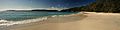
Murrays Beach looking east with Bowen Island at centre
-
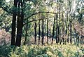
Regrowth after fire, March 2019
-
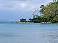
Greenpatch

.jpg)
