
Southerly Buster facts for kids

A southerly buster is the common name for a sudden change in wind direction that brings cool air from the south. It happens in the southern parts of New South Wales and Victoria, Australia. This wind change usually arrives on a hot day, bringing cool air and often a big drop in temperature. It replaces the hot conditions with much cooler ones. Sometimes, a southerly buster looks like a long, roll-up cloud that appears from the south, moving with the wind change. Other times, you might not see much before it arrives.
Southerly busters happen about 32 times each year along the coast of southeastern Australia, mostly in spring and summer. They can be strong or mild. While they are well-known in NSW and Victoria, they also occur on the east coast of Tasmania, in New Zealand, and even in countries like Argentina and Chile. In North America, similar weather events are called ‘backdoor fronts’, and in Western Europe, they are known as ‘Spanish plumes’.
Contents
History of Southerly Busters
Early Observations


In 1819, an English explorer named William Wentworth wrote about a southerly buster he experienced in Sydney. He noted that hot northwesterly winds usually lasted only a couple of days. Then, a cold southerly wind would arrive, often with rain. He observed that the temperature could drop by 15 to 22 degrees Celsius in just half an hour! These cold southerly winds typically lasted for 12 to 24 hours before the regular sea and land breezes returned.
From the very first days of European settlement in Sydney, these sudden southerly winds were a problem for boats in the harbour. In 1829, one of these squalls, then called a "brickfielder," nearly capsized the boat carrying Governor Ralph Darling and his family. Later, boatmen in Port Jackson started calling it the "Sútherly Búster." In the early days, Sydney's summer storms often brought rolling red dust from the colony's brick-making areas.
Warning Signals
In 1869, a system was set up to warn ships about approaching strong winds. This happened after lighthouses and signal stations along the NSW east coast were connected by telegraph. This system helped boats in Port Jackson know when a buster was coming. A special diamond shape was displayed on the southern arm of a signal mast to show a squall was approaching from the south. Numbers were also flown to show where the squall was located, for example, Jervis Bay was 46 and Wollongong was 82. These signal masts were at South Head Signal Station and Fort Phillip.
In 1876, new signals were added at Bradley's Head and a Floating Light Vessel at the harbour entrance. A cone shape pointing downwards on the flagstaff would mean a southerly squall was likely. This signal was first used in England in 1861 by Robert FitzRoy. In 1879, George Herbert Gibson even wrote a book called Southerly Busters, where a buster causes trouble near Hyde Park, Sydney.
In November 1898, a new system started at the General Post Office, Sydney. A white flag with the letters E, J.B., or W would be flown from the clock tower. These letters stood for Eden, Jervis Bay, or Wollongong. When the wind reached one of these places, the matching flag would be raised. The J.B. flag was first used on February 10, 1899, but the wind didn't go past Kiama that day. It had been a very hot day, and the expected cool change didn't arrive for everyone.
20th Century Signals
On December 16, 1908, a new night signal was introduced at the GPO clock tower: a red light in the lantern room. This light was used until 1940. Even with warnings, boats still sometimes capsized, but fishing boats generally paid attention to the signals.
In 1931, the Bureau of Meteorology weather forecasts, which used flags, were expanded to include southerly buster warnings. With help from the Royal Australian Navy, these signals were also displayed at Garden Island. A diamond shape was hoisted during the day, and a red light at night, when a southerly buster was expected. In 1932, Navy League sea cadets used the same signals at their station on Snapper Island (New South Wales).
The Weather beacon on top of the MLC Building, North Sydney, built in 1957, could also warn of southerly busters. The lights on the beacon were updated several times a day. If a 'buster' was expected, the red lights at the bottom of the beacon would flash quickly. This signal meant strong winds and rain were coming. A popular jingle helped people remember:
Flashes short, prepare for gales, Gather the washing, furl the sails."
Author Ruth Park mentioned the southerly buster in her 1949 novel, Poor Man's Orange:
After an unbearably hot day, the old men on the balconies were sniffing the air and saying, 'Here she comes!' The Southerly Buster, the genie of Sydney, flapped its coarse wing over the city ... The women undid the fronts of their frocks and the little children lifted up their shirts and let it blow on their sweaty bottoms.
How a Southerly Buster Forms

On a hot day, a strong wind from the south often develops in the late afternoon or early evening. When it arrives, the temperature drops quickly. Sometimes, a short period of rain or a thunderstorm can come with it, especially if it's linked to a cold front and a trough. The strongest winds are usually right at the front edge of the buster. However, southerly busters don't always bring heavy rain, sometimes just light drizzle. Their effects can last for up to 24 hours.
Scientists believe a southerly buster is like a "coastal gravity current." This means cool, heavy air flows along the coast, pushed against the mountains by the Coriolis force (a force caused by Earth's rotation). It forms when a cold front hits the Great Dividing Range (a mountain range in eastern Australia). The mountains block the cold air, causing it to bend and spread northward along the coast.
The interaction with the Great Dividing Range is key. The cool air gets trapped against the mountains, especially in the Gippsland area of Victoria. The mountains create a "channelling effect," guiding the southerly winds along the New South Wales coast. While the inland part of the cold front is held back by the mountains, the part over the sea keeps moving along the shore, twisting the front into an 'S' shape. This continues along the southern New South Wales coast, while areas ahead of the front are still experiencing hot northwesterly winds.
Characteristics of a Buster
The main sign of a southerly buster is the sudden, strong change in wind direction from northwesterly to southerly. This is always followed by a clear drop in temperature and a rise in air pressure. Wind gusts can be stronger than 74 km/hour, especially after very hot days. These strong winds usually calm down within 30 to 60 minutes after the buster arrives, becoming quite light within a few hours.
A typical southerly buster is between 37 and 111 kilometers wide. The strongest winds are usually closer to the sea. Its height is about 1000 meters, limited by the height of the mountains to the west.
A southerly buster is a mesoscale weather event, meaning it develops over about one day. Because busters don't always move at a steady speed along the coast, it has been hard to predict their exact arrival. However, today, meteorologists use satellite imagery and weather radar to forecast them, and the Bureau of Meteorology issues wind warnings.
Temperature changes can be dramatic. Drops of 10°C to 15°C often happen in just a few minutes. In extreme cases, a southerly buster can lower temperatures from 40°C to 19°C. It's worth noting that some southerly busters can be mild. They might arrive on warm days or during humid thunderstorms, bringing only light, but still noticeable, cooler winds in the evening. Their effects can sometimes last for a few days.
Regions Affected
- In New South Wales, southerly busters are usually strongest between Nowra on the South Coast and Newcastle. They rarely go beyond the Mid North Coast or Port Macquarie. If they do, it's usually because a tropical cyclone off the northern coast strengthens them. In these northern areas, the temperature changes are less dramatic. Southerly busters also affect inland parts of NSW, especially in the southeastern block of the state. This includes areas like Greater Western Sydney, the eastern part of the Central Tablelands (east of Bathurst), the lower Hunter Valley, and sometimes Albury in the South West Slopes. Cooma in the Monaro (New South Wales), Canberra in the ACT, Goulburn in the Southern Tablelands, and the Snowy Mountains also experience them. The southern regions often have the most dramatic cool changes. Sydney gets about five southerly busters a year, mostly in late spring and early summer. The stronger ones usually reach the city in the late afternoon or early evening on a hot day. This weather event is very important for people who sail in Sydney.
- In Victoria, especially in Melbourne, southerly busters happen in the afternoons. The strong heat, brought by north-westerly winds from central Australia, suddenly gives way to a quick drop in temperature, followed by rain, thunderstorms, and a relatively cool night. They can reach as far inland as Swan Hill in the north and Omeo to the east, but they are less strong and noticeable further inland. Temperature drops in these parts of Victoria are even more dramatic than in eastern New South Wales, with a 10°C drop possible within half an hour. Southerly busters appear most often in spring. This is because the land north of Melbourne starts to warm up, but the Southern Ocean, which brings cool breezes to Victoria from the west, doesn't warm up as quickly. The big temperature difference between the hot air from the north and the cold air from the ocean creates good conditions for thunderstorms.
- In South Australia, Mount Gambier is most affected by southerly busters because of its southeastern location. The buster can also reach Adelaide and Whyalla sometimes.
- In Western Australia, the buster occasionally reaches Eucla during the warm months. This is due to its location near the Southern Ocean, and it can experience big temperature drops.
- In Wellington, New Zealand, these storms are usually short. They often have winds gusting between 120 km/h and 160 km/h, and sometimes even higher speeds.
- In South America, similar southerly fronts often move onto the southern coast of Chile and Argentina. They then move northward on both sides of the Andes mountains.
- In North America, the 'back-door' cold front that moves south on the eastern side of the Alleghenies in the northeastern US is similar to the southerly buster of the southern hemisphere.
Records
The strongest recorded Southerly Buster happened around 4:30 pm on March 12, 2010, in Wellington, New Zealand. It had a maximum gust of 133 km/h.
Henry Ambrose Hunt, in his essay "An Essay on Southerly Bursters," mentioned the Dandenong Gale as a buster. He wrote that the wind reached an amazing speed of 246 km/hr in one gust! The SS Dandenong ship sank off Jervis Bay during this gale, and 40 lives were lost.
While that specific speed is no longer officially recognized, events like the 'Kurnell Tornado' show that gusts over 200 km/hr are possible in the area. The day before that tornado, a southerly buster had been predicted.
Incidents
On November 21, 2016, around 6 pm, a powerful southerly change hit Melbourne. This event led to the tragic deaths of 10 people who had asthma and suffered from breathing problems. Thousands of others across the city experienced allergic reactions and asthma-like symptoms, a phenomenon known as thunderstorm asthma.
This happened because a strong southerly wind (60 km/hour) spread ryegrass pollen into the moist air. The pollen grains then broke into very tiny pieces, small enough to enter people's lungs. These tiny particles were sucked up into the warm air of the forming storm cells. Then, they fell back to Earth in the storm's cool downdraft, spreading across the land. Hospitals and medical centers in Melbourne had to handle 8,500 emergency calls in just five hours, and 1400 people were hospitalized.
Images for kids
-
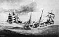
Artist's impression of Dandenong (right) sinking in Jervis Bay in 1876
.jpg)
