Central Tablelands facts for kids
Quick facts for kids Central TablelandsNew South Wales |
|||||||||||||||
|---|---|---|---|---|---|---|---|---|---|---|---|---|---|---|---|

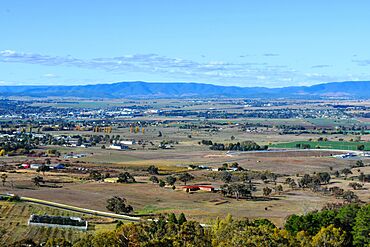
Typical pastural vistas in the region (Bathurst)
|
|||||||||||||||
| LGA(s) | Bathurst, Blayney, Lithgow, Mid-Western, Oberon, Orange | ||||||||||||||
| State electorate(s) | Bathurst, Dubbo, Orange | ||||||||||||||
| Federal Division(s) | Calare, Parkes | ||||||||||||||
|
|||||||||||||||
The Central Tablelands is a special part of New South Wales, Australia. It's located between the big city of Sydney and the flatter lands to the west. This area is known for its beautiful landscapes, including parts of the Great Dividing Range and the famous Blue Mountains.
Many main roads cross through the Central Tablelands. These include the Great Western Highway and the Mitchell Highway. The main train line from Sydney also runs through this region, heading west.
Some of the biggest towns here are Orange, Bathurst, and Lithgow. Other towns include Mudgee, Blayney, and Oberon.
Contents
Exploring the Central Tablelands: A Look Back in Time
In May 1813, three brave explorers named Blaxland, Wentworth, and Lawson set out on an adventure. They wanted to find out what was beyond the Blue Mountains, west of Sydney.
First Steps into the Unknown
The group successfully climbed the mountains. They reached a spot later called Mount Blaxland. This was the first time Europeans had reached the area we now call the Central Tablelands.
Discovering Bathurst
Later that year, in November 1813, Governor Macquarie sent another expedition. This one was led by a government surveyor, George Evans. Evans's group traveled even further. They reached the place where the city of Bathurst now stands.
Naming Orange
The town of Orange got its name from another explorer, Thomas Mitchell. He started one of his big trips from this region. He was joined by a local guide and interpreter from the Wiradjuri people, named Turandurey.
Landforms and Landscapes: What the Earth Looks Like
The Central Tablelands is a very interesting area when it comes to its land. It has mountains, valleys, and rivers. The rocks here tell a long story about how the Earth has changed over millions of years.
The Blue Mountains Area
The eastern part of the Central Tablelands includes the Blue Mountains. This area is west of Sydney. Many creeks and rivers flow through here. These rivers eventually join the Hawkesbury-Nepean river system.
The Blue Mountains are a huge plateau made mostly of Triassic sandstone. A plateau is a large, flat area of land that is higher than the land around it. The mountains can reach up to 1,100 meters high near Mount Victoria. They end in a line of cliffs that form the edge of valleys like Hartley and Megalong.
Around Bathurst
The area around Bathurst has two main types of land. There's the Bathurst Basin, which is like a bowl-shaped area, and the surrounding tablelands. Rivers like the Macquarie and Campbells River drain this region.
The central part of Bathurst has mostly granite soils. Granite is a very hard rock. In other parts, you can find sandstone, limestone, and even signs of old volcanoes. The land here can be gently rolling or very steep and rough.
Around Mudgee
The northern part of the Central Tablelands, near Mudgee and Gulgong, is also very diverse. The Cudegong River flows through this area. It starts in the mountains of the Great Divide and flows west.
The eastern side of this valley has high mountains that were formed by volcanoes. These mountains are topped with basalt lava flows from about 17 million years ago. Nullo Mountain and Mount Coricudgy are some of the tallest peaks. This area has amazing landscapes with basalt peaks, sandstone ravines, and rainforest gorges. As you go west, the land becomes wide, fertile basins perfect for farming.
Weather in the Central Tablelands: Four Seasons of Fun
.
Because of its height above sea level (from 450 to 1,395 meters), the Central Tablelands gets to enjoy all four seasons!
Summer (December to February)
Summers can be quite hot, sometimes reaching over 40°C. But the afternoons often cool down. Most summer nights are comfortable, around 13°C.
Autumn (March to May)
Autumn is when the weather starts to get cooler. Around April, you might start to see frosts. Temperatures can drop below 0°C. It can also be quite windy, and some days might not get warmer than 18°C.
Winter (June to August)
Winter is the coldest season. Daytime temperatures often stay below 7°C. On cold winter nights, especially when cold air comes from the southwest, temperatures can drop as low as -8°C. Frosts happen very often. In the higher areas, above 1,000 meters, it often snows several times each winter.
Spring (September to November)
Spring is when the weather starts to warm up again. Even in early spring, you might still see frosts or even a bit of snow. By mid-spring, temperatures can reach 24°C or even higher. This is when crops and flowers start to grow all over the Central Tablelands. Nights in spring can still be quite cold, often dropping below 0°C.
Rainfall and Records
The lower parts of the region tend to be drier. However, areas like the Oberon Plateau get much more rain. You can expect rain any day of the year, but the heaviest rainfall usually happens around October. The average rainfall is between 600 and 1,000 mm per year. But the amount of rain can change a lot from year to year.
The hottest temperature ever recorded in the Central Tablelands was 44.7°C in Bathurst in January 1878. The coldest temperature was -11.1°C in Marrangaroo in July 2018.
How Regions are Named in New South Wales
New South Wales is divided into four main types of land:
- the coastal regions along the Tasman Sea in the east
- the highlands, which are elevated tablelands and part of the Great Dividing Range
- the western slopes of the highlands, which are great for farming
- the dry western plains
These four types of land are then usually divided into northern, central, and southern areas. This is based on where they are located compared to Sydney.
This way of dividing the state gives us names for regions like:
- North Coast
- Central Coast
- South Coast
- Northern Tablelands
- Central Tablelands
- Southern Tablelands
- North-West Slopes
- Central Western Slopes
- South-West Slopes
- Western Plains
 | John T. Biggers |
 | Thomas Blackshear |
 | Mark Bradford |
 | Beverly Buchanan |


