
Blue Mountains (New South Wales) facts for kids
The Blue Mountains are a beautiful mountainous area and a mountain range in New South Wales, Australia. They are located just west of Sydney, about 50 kilometres (31 miles) from the city centre.
The Blue Mountains get their name from the special blue haze you can often see when you look at them from far away. This blue colour comes from tiny particles in the air that scatter light, especially from the many eucalyptus trees that grow there. It's like a natural filter that makes the mountains look blue!
This region is home to amazing wildlife, deep valleys, and towering cliffs. It's also a place with a rich history, especially for the Aboriginal people who have lived there for thousands of years.
Quick facts for kids Blue MountainsNew South Wales |
|||||||||||||||
|---|---|---|---|---|---|---|---|---|---|---|---|---|---|---|---|

The Three Sisters sandstone rock formation, one of the region's best-known attractions
|
|||||||||||||||
| Area | 11,400 km2 (4,401.6 sq mi) | ||||||||||||||
| Location | 50 km (31 mi) NW of Sydney CBD | ||||||||||||||
| LGA(s) | Blue Mountains | ||||||||||||||
| State electorate(s) |
|
||||||||||||||
| Federal Division(s) | |||||||||||||||
|
|||||||||||||||
| Blue Mountains Range | |
|---|---|
| Blue Mountains | |

The characteristic blue haze,
as seen in the Jamison Valley |
|
| Highest point | |
| Peak | unnamed peak (north-east of Lithgow) |
| Elevation | 1,189 m (3,901 ft) AHD |
| Dimensions | |
| Length | 96 km (60 mi) NW/SE |
| Geography | |
|
Lua error in Module:Location_map at line 420: attempt to index field 'wikibase' (a nil value).
|
|
| Country | Australia |
| State | New South Wales |
Contents
- Why are they called the Blue Mountains?
- How were the Blue Mountains formed?
- Who lived in the Blue Mountains first?
- When did Europeans explore the Blue Mountains?
- What is the climate like?
- What kind of plants and animals live there?
- What are the main mountain peaks?
- Why is it a World Heritage Site?
- What are the main attractions?
- What can you do for fun?
- Images for kids
- See also
Why are they called the Blue Mountains?
When European settlers first saw the mountains from Sydney, they noticed a blue colour. This blue look is caused by something called Mie scattering. Tiny particles in the air scatter light, especially the blue light. The many eucalyptus trees in the Blue Mountains release tiny oil droplets into the air. These droplets help create the blue haze that gives the mountains their name.
How were the Blue Mountains formed?
The Blue Mountains are a sandstone plateau covered in eucalyptus forests. This area sits on top of very old rock, about 470 million years old!
Long, long ago, a shallow sea covered this region. Rivers brought in different kinds of mud and sand. Over millions of years, these layers of sand and mud turned into rock. About 1 million years ago, the Blue Mountains started to form. Deep valleys and steep cliffs were carved out by erosion from water and wind. The highest parts of the mountains are about 1,189 metres (3,900 feet) high.
One of the most famous rock formations is the Three Sisters. These are three giant sandstone peaks that have been shaped by wind and rain over time.
Who lived in the Blue Mountains first?
The Blue Mountains have been home to Aboriginal people for thousands of years. The Gundungurra people lived in the upper Blue Mountains, and the Darug people lived in the lower areas.
The Gundungurra people have a special creation story about the Blue Mountains. They believe that two powerful Dreaming creatures, Mirigan and Garangatch, who were half fish and half reptile, fought a huge battle. This battle created the deep scars in the landscape that we now know as the Jamison Valley.
You can still see signs of Aboriginal life in many places. For example, at the Red Hands Cave near Glenbrook, there are ancient hand stencils on the rock walls. These were made by adults and children long ago. At Kings Tableland Aboriginal Place near Wentworth Falls, you can find grinding grooves where tools were sharpened. This site is believed to be 22,000 years old!

When did Europeans explore the Blue Mountains?
When Europeans first settled in Sydney, they thought the Blue Mountains were impossible to cross. They believed there were rich lands beyond the mountains.
A former convict named John Wilson might have been the first European to cross the mountains in 1797. He lived with Aboriginal people and learned their ways. He described exploring far beyond Sydney, possibly guided by Aboriginal people.
However, the official first successful European crossing was in 1813. Gregory Blaxland, William Lawson, and William Charles Wentworth led an expedition. They started on May 11, 1813, and managed to cross the mountains by May 31. They reached an area now called Mount Blaxland.
After their success, Governor Macquarie sent a surveyor, George Evans, to explore further. Evans found the Fish and Macquarie rivers and the site of Bathurst.
To make it easier to travel, a road was built across the mountains. William Cox started building this road on July 7, 1814. About 30 convict labourers and 8 guards worked hard to finish the road in just 27 weeks, by January 14, 1815.
What is the climate like?
The weather in the Blue Mountains changes depending on how high up you are. In places like Katoomba, which is about 1,010 metres (3,314 feet) high, summers are mild. The average maximum temperature is around 22 °C (72 °F). Sometimes it can get hotter, but it's often cooler than Sydney.
In winter, the daytime temperature is usually around 10 to 11 °C (50–52 °F). Nights can get cold, sometimes dropping below freezing. The Blue Mountains usually get two or three snowfalls each year, making it a beautiful winter wonderland!

What kind of plants and animals live there?
The Blue Mountains are covered in eucalyptus forests. In sheltered areas, you can find temperate rainforests. There are also unique "hanging swamps" with special plants.
One very special tree found here is the Wollemia nobilis, also known as the "Wollemi pine." This tree is like a living fossil, a plant that has existed since the time of the dinosaurs! It's found in very remote and hidden valleys.
The Greater Blue Mountains Area is home to over 400 different types of animals. You might find rare mammals like the spotted-tailed quoll, the koala, and the yellow-bellied glider. There are also unique reptiles, such as the Blue Mountain water skink. Dingoes live here too, hunting for animals like grey kangaroos.

What are the main mountain peaks?
The Blue Mountains are made up of many smaller mountain ranges and peaks. Some of the major peaks include:
- unnamed peak (1,189 metres or 3,901 feet)
- Mount Piddington (1,094 metres or 3,589 feet)
- Mount Boyce (1,093 metres or 3,586 feet)
- Mount York (1,061 metres or 3,481 feet)
- Mount Banks (1,049 metres or 3,442 feet)
- Mount Wilson (1,008 metres or 3,307 feet)
Why is it a World Heritage Site?
The Greater Blue Mountains Area was named a World Heritage Site by UNESCO in 2000. This means it's considered a very important natural place for everyone in the world to protect.
The area is huge, covering about 10,000 square kilometres (3,861 square miles). It includes seven national parks and a conservation reserve. It was chosen because of its amazing eucalyptus forests and the many different kinds of plants and animals that live there, including some that are found nowhere else on Earth!
What are the main attractions?
The Blue Mountains are a very popular place for tourists. Here are some things to see and do:
-
 View from Wentworth Falls carpark
 - The Three Sisters near Katoomba, New South Wales are a famous landmark and a great spot for photos.
- The Giant Stairway is a walking track that goes down a cliff into the Jamison Valley, offering amazing nature walks.
- Jenolan Caves are a series of beautiful limestone caves south west of Katoomba.
- Katoomba Scenic Railway is a very steep railway that takes you down into the valley. You can also ride the Scenic Skyway, a glass-bottom cable car, or the Scenic Cableway, the steepest cable car in Australia.
- The Norman Lindsay Gallery and Museum at Faulconbridge is a museum in the former home of artist Norman Lindsay.
- The Zig Zag Railway is a fun steam-powered railway near Lithgow.
- Red Hands Cave in the Blue Mountains National Park near Glenbrook has some of the best examples of Aboriginal art in the area.
- Lincoln's Rock in Wentworth Falls, New South Wales gives you spectacular views of the Jamison Valley.

What can you do for fun?
The Blue Mountains are a fantastic place for outdoor adventures!
- Rock climbing: There are many great cliffs for rock climbing, like those near Blackheath.
- Mountain biking: You can ride on many fire trails that branch off the main roads.
- Hiking: There are countless walking trails for all skill levels, from easy strolls to challenging hikes.
- Canyoning: This involves exploring canyons by walking, swimming, jumping, and sometimes abseiling. It's an exciting way to see hidden parts of the mountains.
- Abseiling: You can try abseiling down cliffs with guides.
Images for kids
-
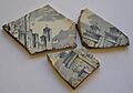
Broken china from ruins near Asgard Swamp, where a coal mine was opened in the nineteenth century
-
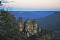
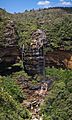
The typical blue haze in the Jamison Valley behind the Three Sisters, New South Wales, Australia.
-
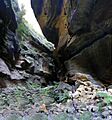
Neates Glen, outside Blackheath
-
Upper Wentworth Falls as viewed along the National Pass walking track near the town of Wentworth Falls
-
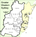
The Greater Blue Mountains Area is considered to be part of Greater Western Sydney region.
-
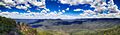
Megalong Valley
-
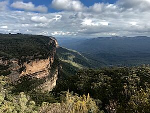
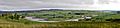
View of Jamison Valley from north escarpment, outside Katoomba:Three Sisters far left; Mount Solitary left of centre; Narrowneck Plateau, far right
Asgard_Swamp_broken_china-1.jpg)


See also
 In Spanish: Montañas Azules (Australia) para niños
