
Mount York facts for kids
Quick facts for kids Mount York |
|
|---|---|

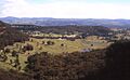
The view from Mount York,
looking west over Hartley |
|
| Highest point | |
| Elevation | 1,061 m (3,481 ft) |
| Geography | |

Mount York
Location in New South Wales
|
|
| Location | Blue Mountains in New South Wales, Australia |
| Parent range | Explorer Range, Blue Mountains Range |
| Climbing | |
| Easiest route | Great Western Highway Mt York Rd |
Mount York is a special mountain in the Blue Mountains of New South Wales, Australia. It is about 150 kilometers (93 miles) west of Sydney. This mountain is part of the Explorer Range, which is a branch of the larger Great Dividing Range.
Mount York stands 1,061 meters (3,481 feet) high. It is like a natural balcony sticking out from the Blue Mountains. From its top, you can see amazing views of the land below.
Contents
Exploring Mount York's Nature
Mount York is mostly covered in eucalypt trees. These trees form an open forest canopy. Many small creeks flow down the mountain's sides. They eventually join the Coxs River system.
Mount York has a twin peak called Lockley Promontory. Both peaks stick out towards the northwest. They start near the small mountain village of Mount Victoria.
Plants and Animals at Mount York
You can find many native animals and plants here. Birdwatching is a popular activity. You might spot colorful birds like the Yellow Cheeked Black Cockatoo or the King Parrot.
Many termite mounds can be seen along the roads. The mountain rises about 200 to 300 meters (650 to 980 feet) above the Hartley Valley.
Mount York's Important History
Mount York is famous for its role in Australian exploration. In 1813, three explorers named Gregory Blaxland, William Lawson, and William Wentworth stood here. They were the first Europeans to successfully cross the Blue Mountains. From Mount York, they saw the Hartley Valley and the lands to the west for the first time.
Memorials and Lookouts
Their important journey in 1813 opened up new areas for farming. Today, several memorials stand at the summit to remember their achievement. One memorial even has their faces carved in stone.
There are also two metal-fenced lookouts. One faces west, and the other faces north. They offer stunning views of the surrounding landscape.
Old Roads and Walking Tracks
Mount York was a key spot for building paths to the plains. The first path was Coxs Road, built in 1813. Another road, Lockyers Road, was started soon after but never finished. Lawsons Long Alley was also built a bit east of Lockyers Road.
These early roads were eventually abandoned. However, in recent years, they have been turned into walking tracks. The Department of Lands in New South Wales and the Blue Mountains City Council now manage them.
Berghofers Pass is another old road that became a walking track. It was abandoned when newer roads were built. John Berghofer, who built this pass, is buried in the Mount Victoria Cemetery.
Heritage Sites at Mount York
Mount York has several places listed for their historical importance. These include:
- Blue Mountains National Park: Blue Mountains walking tracks
Images for kids
-
The view at the end of Berghofers Pass
-
Historic inscriptions along Berghofers Pass

Bergofers_Pass.jpg)
