Mount Banks facts for kids
Quick facts for kids Mount Banks |
|
|---|---|

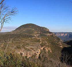
Mount Banks pictured in 2009
|
|
| Highest point | |
| Elevation | 1,049 m (3,442 ft) |
| Geography | |
| Location | Blue Mountains, New South Wales, Australia |
| Parent range | Explorers Range, Blue Mountains Range |
| Climbing | |
| First ascent | George Caley (European, 1804) |
| Easiest route | Bells Line of Road |
Mount Banks is a cool mountain in the Blue Mountains National Park in New South Wales, Australia. It's about 100 kilometers (62 miles) west of Sydney. This mountain is part of the Explorers Range, which is a smaller part of the bigger Blue Mountains Range. Mount Banks stands 1,049 meters (3,442 feet) high. It's pretty easy to get to, especially by using the Bells Line of Road. The closest town is Mount Tomah, about 8 kilometers (5 miles) away.
Contents
Exploring Mount Banks: What's it Like?
Mount Banks is part of the Explorers Range. This range is found along the northern edge of the Grose Valley in the Blue Mountains National Park. The Explorers Range begins at Bells Line of Road and stretches along the valley's northern side. Mount Banks is the first big peak you'll notice in this range. It's about 2 kilometers (1.2 miles) from Bells Line of Road.
The mountain was named in 1804 by an explorer named George Caley. He worked for a famous botanist, Sir Joseph Banks. George Caley was the first European person to reach Mount Banks.
Unique Features of Mount Banks
One really interesting thing about Mount Banks is how the land and plants change as you get closer to the top. For most of the walk, you'll see the usual sandstone rock, which is common in the Blue Mountains. This area has thin, rough bushes.
But then, you'll reach a special layer of rock called a basalt cap. This basalt layer makes the soil much richer! Because of this, you'll find lots of green grass and tall trees, creating a beautiful, leafy forest.
You can see amazing views of the area from the lower parts of the mountain. However, there isn't a view right at the very top. To see the Grose Valley, you need to walk a little way down the slope towards the edge of the mountain.
Getting to the Top of Mount Banks
There's an unsealed road that leads from Bells Line of Road to a picnic area. This picnic spot is about 1 kilometer (0.6 miles) from the main road. You can't drive any further than this point.
From the picnic area, a walking path goes for about 1 kilometer (0.6 miles) to the very top of Mount Banks. At the summit, you'll find a trigonometric station. This is a special marker used for surveying, and it's 1,062 meters (3,484 feet) above sea level.
From the top, there's also a fire trail. This trail follows the Explorers Range and ends above a place called Zobel Gully. Maps show there might be an old, abandoned mine in Zobel Gully, but there isn't a path to get to it.
Fun Activities at Mount Banks
Mount Banks is a great place for bushwalking. You can enjoy wide, open views of the Grose Valley from the lower slopes of the mountain. The fire trail also offers great views, especially where it gets close to Banks Wall, which is about 1 kilometer (0.6 miles) south of the mountain.
Many people also love to take photos here because of the amazing scenery. It's important to know that there are no official camping spots at Mount Banks. Camping is not allowed in this special World Heritage Site to help protect its fragile environment.
 | Roy Wilkins |
 | John Lewis |
 | Linda Carol Brown |


