
Mount Blaxland (New South Wales) facts for kids
Quick facts for kids Mount Blaxland |
|
|---|---|
| Highest point | |
| Elevation | 901 m (2,956 ft) |
| Naming | |
| Etymology | Gregory Blaxland |
| Geography | |
| Location | Central Tablelands |
| Country | Australia |
| State | New South Wales |
Mount Blaxland is a significant hill located about 15 kilometres south of Lithgow in Australia. It's famous for being the furthest point reached by three early explorers: Blaxland, Lawson, and Wentworth. They reached this spot during their important journey across the Blue Mountains in 1813.
Contents
What is Mount Blaxland?
Mount Blaxland is not a huge mountain, but rather a large hill. It stands about 901 metres (2,956 feet) above sea level. This hill is found in the Central Tablelands region of New South Wales, Australia. Today, Mount Blaxland is located on private land near South Bownfels, south of Lithgow.
The First Explorers
In 1813, three explorers – Gregory Blaxland, William Lawson, and William Wentworth – made history. They were the first Europeans to successfully cross the difficult Blue Mountains. Before their journey, the mountains were a big barrier. They stopped the early settlements from expanding further inland.
Their expedition was very important for the colony of New South Wales. It opened up new lands for farming and settlement. Mount Blaxland marks the furthest point they reached on this groundbreaking journey.
How Mount Blaxland Got Its Name
The name "Mount Blaxland" was given to the hill by Surveyor-General George Evans. Later in 1813, Evans followed the path of Blaxland's expedition. When he reached the spot where Blaxland, Lawson, and Wentworth had turned back, he decided to name it. He named the hill after Gregory Blaxland, one of the three explorers.
Evans also named two other smaller, cone-shaped hills nearby. These hills were on the opposite side of a stream. He called them "Wentworth's Sugar-Loaf" and "Lawson's Sugar-Loaf." This was to honour the other two explorers on the expedition.
Images for kids
-
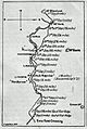
A sketch of Blaxland, Lawson and Wentworth's route across the Blue Mountains in 1813 prepared by F Walker in 1913. The Great Western Road has been inserted to show how closely it has followed the track of the explorers in its general direction.

